Crater (8,125ft)
July 3, 2016
Linsey Warren
Dave G.
Mike R.

Brickyard P&R – 5.00am
Ashway P&R – 5.30am
Depart TH – 8.30am
Lake – 11.30am
Summit – 1.30pm
Lake – 4.15pm
Arrive TH – 6.10pm
Ashway – 9.20pm
My fate this year seems to be organizing last minute weekend trips. I feel like I need some go packets and ideas. So a week ago I picked up the Top 200 list and put them into Google Earth so I could have a good idea of where peaks were and they could provide some loose inspiration. I don’t think I want to get too attached to another list – as that has proven to drive me to distraction in the past. But having a list of ideas helps me find peaks for weekend trips. So as Lincoln yet eludes me due to weather and conditions I found myself searching for a last minute weekend trip. As a side note Kyle now refers to Lincoln peak as ‘The Unicorn’ as it’s been quite elusive this year. I think now that it may be a bit late to try it and the conditions would make it more difficult. And given the exposure and technical nature of the climb I’m not sure if I’m looking for anything to make it harder.
People were throwing out ideas. I kind of wanted to go for a two day trip before the fourth but am glad in the end Dave only had Sunday because that gave me Saturday to decompress and rest a little. Dave had suggested a couple things on the Eastside near Leavenworth but after having three ticks on me this year I opted for ‘not the Eastside’ and we headed up to Highway 20 to try Crater Mountain.
Years ago while pursuing the hundred highest I was right under Crater Mountain and sat with John while Anne and Eileen scrambled up it. I was kicking myself a little for not doing it then. But since it was supposed to be mostly a trail to the top it seemed like a good peak to try on an iffy weather weekend. Mike R. decided to join us last minute, after having done Forbidden not two days before. I sent out word that we should me at Dave-o-clock in the morning and we had a plan. I got up at 4am so that I could leave the house at 4.40am and be at the Brickyard at 5.00am. As Kyle was getting onto the freeway I got a message from Mike saying he’d overslept his alarm and was running late. Fine. I’d have time to stop at Starbucks for breakfast and some lunch goodies. Not five minutes after that Dave sent me a message saying he was running late as well. Lord. The one day I manage to get up and am running on time no one else is!

So Dave and I met at the Brickyard and I loaded my gear into his car. It seemed like it’d be more efficient if we drove up to the Ashway Park and Ride to meet Mike because then we’d be able to grab my Starbucks and Mike hopefully wouldn’t have to drive as far. But before we got going Kyle and I gave Dave his stickers that we had made for him. There’s a caution symbol and it says ‘One Speed Dave’ on the sticker. A nod to how fast Dave is and how many times I have asked him over the years if he knows what the world mosey means. The gift given we quickly hopped in the car and headed up to meet Mike. It all seemed to work out fine. We then switched our gear into Mike’s car and headed off towards Crater Mountain. As we passed through Everett it started to rain. There was a part of my tired brain that registered that I hadn’t brought rain pants, and another part of my brain that just didn’t care enough to worry. I could wear a trash bag if I needed to. Sometime after Darrington I fell asleep draped across Mike’s pack which was in the back seat. I came to as we were nearing Newhalem and Mike said he needed a break from driving and Dave needed a break for the bathroom. Once we got going again Mike took the back seat and Dave drove (Dave had to drive because both of these gents drive manual cars) and I sat in the front to help navigate and make sure he was fine to drive. Mike managed to catch a few Z’s in the back but it didn’t take us much more than thirty or forty minutes to reach the trailhead from there. At least the weather was looking a little more promising on the crest.
Fortunately we had day packs so they weren’t too heavy. We debated on bringing a 30m cord just in case but the little information I skimmed over said it was mostly a trail to the top so we opted not to bring it. But on the way out I started to second guess that choice. It always seems to be that when you don’t bring it you need it. So when I was pondering out loud if we should carry our crampons Dave said that it’s whenever he doesn’t bring them that he needs them. So we opted to carry the crampons and ice axes with us. So naturally we didn’t need them in the least. We got moving by 8.30am. As we started off from the trailhead I took a picture for my time reference later and noticed that someone had left a book underneath the trailhead sign titled ‘The Hard Way’. Foreshadowing? I laughed a little and included the book in the photo.
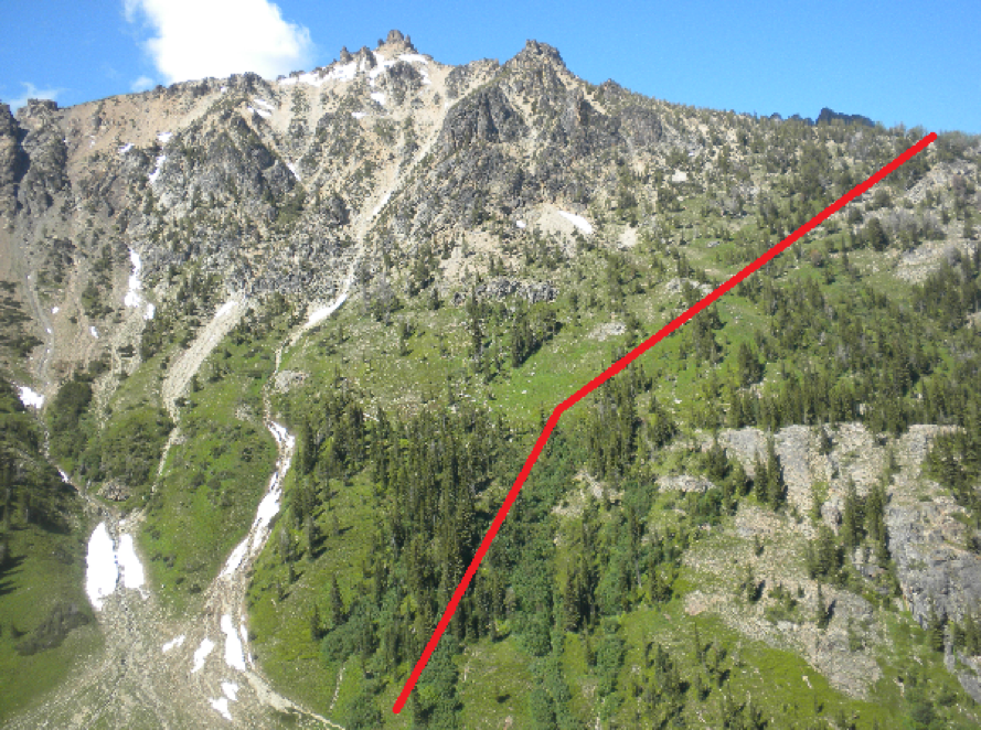
I remembered to turn on the GPS as we left the trailhead. I’m getting better about remembering that! And Mike helped give me some user tips before we started which was nice because I’m not very tech savvy. The trail is very clear and easy to follow as it works across a large bridge. After that we followed the trail to where there is a branch in the trail (to the right for Chancellor and to the left for Jackita). We prematurely took the left fork and as we gained a couple hundred feet I realized that we seemed to be on the wrong side of the river and we quickly checked the GPS and map and realized we had gotten off onto the wrong trail. So we backtracked back to the main trail. It is the Jackita trail (or just staying straight on the path) that leads up to Crater. You’ll know it’s the correct trail because shortly after the first bridge you’ll pass an old cabin and cross a second bridge. It is at the end of this second bridge that the trail T’s. We turned left which, looked unmaintained and not strictly obvious, and followed that to where there was a sign in box and a trail sign. Dave signed us in because he follows the rules! And I had a quick party separation. After that we didn’t take many stops unless it was to grab a quick sip or snack.
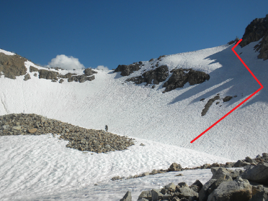
There was quite a bit of blow down on the lower section and some brushy areas but the higher we climbed the conditions seemed to improve for the most part. There were still a few blow downs but mostly the trail was clear and it good shape. We reached the fork in the trail at about 5,200ft and took the left fork to head towards the lake. Someone noted that this was a ‘camp spot’. I tend to think it wouldn’t be a good camp spot. You could probably get a tent there but I don’t think it’d be on even ground and you’d be right in the middle of the trail. It was here at this fork that we encountered our first couple of mosquitos. I hadn’t brought any bug spray but luckily Dave was thinking and brought a small bottle. I didn’t put any on here but I did at the next stop a little closer to the lake after I got a few noticeable bites. We stopped just below the lake at an obvious camp spot. Made more obvious by the fact that someone was camping there. We reached this at about 11.30am and we were talking loudly about who was camped there and whether or not they went up Crater Mountain. I said something to the effect of ‘Why else would you camp here?’ and then we heard rustling in the tent! Opps! A guy poked his head out while we stopped and had a quick bite. We couldn’t have stayed for more than fifteen minutes before heading off. We accidentally took a trail that lead straight to the river (coming from the lake above) which we learned was most likely for accessing water. So we backtracked the 50 feet to the trail and continued heading uphill towards the lake proper. You cross the ‘river’ at the outlet proper. There were some small logs and branches laid down to walk across.
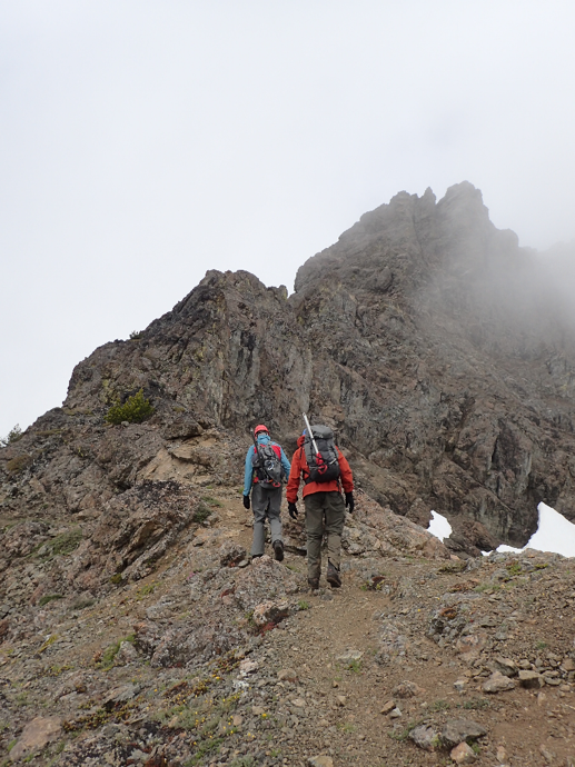
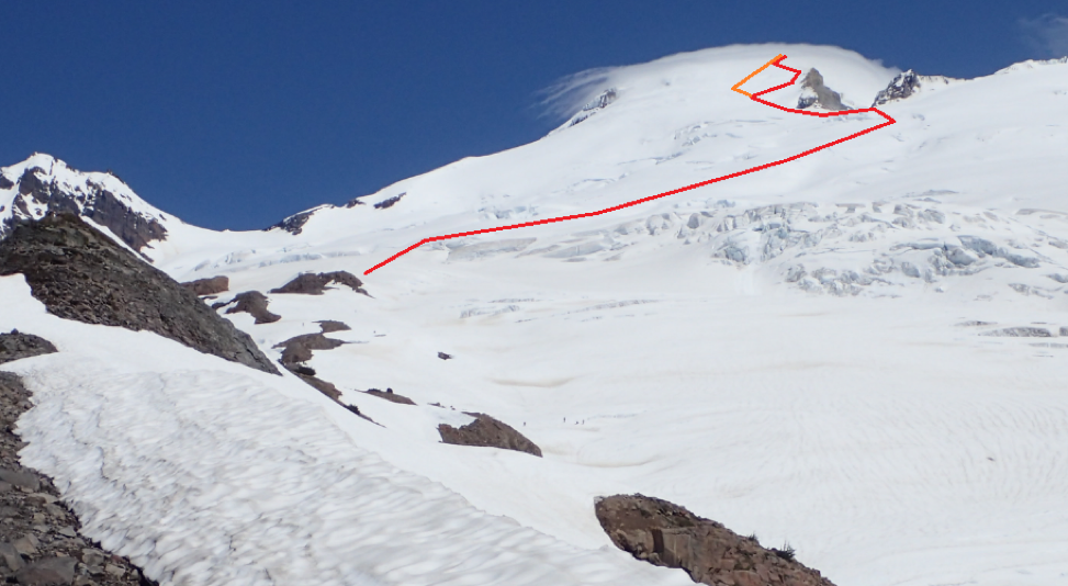
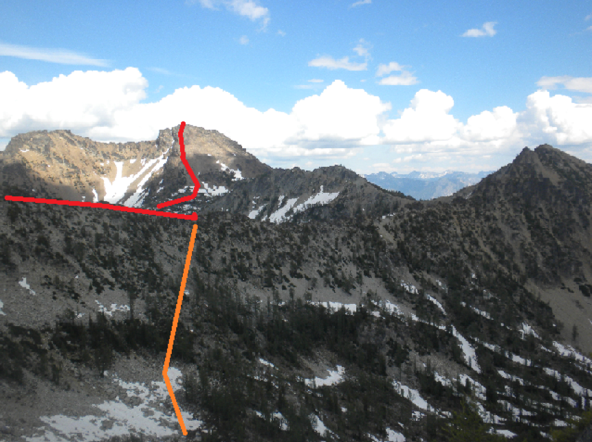
We crossed over and followed the trail as it wound around the south side of the lake and then headed up towards the ridge. It was here at about 5,700ft or so that there were intermittent patches of snow. It stayed spotty up the ridge but the ridge is very moderate so it was easy to make a way up even when we strayed off the trail onto the snow. The wind picked up on the ridge and it started trying to mist on us. I was willing the weather to cooperate in my mind, but part way up we had to stop to put rain jackets to protect against the wind. And since we were stopped we put on our helmets. The clouds kept Crater mostly shrouded but it wasn’t too hard to follow the ‘trail’ around to the west side of the mountain. Just below the ridge I recognized a rocky spot where John and I had sat down one sunny day many years ago to wait for Anne and Eileen to summit Crater. I felt like I could see the ghosts of the past. I could see how sunny it was and where we were sitting and almost hear our conversation from all that time ago. Circumstances in stark contrast to the cloudy, very nearly sprinkling day we were experiencing.
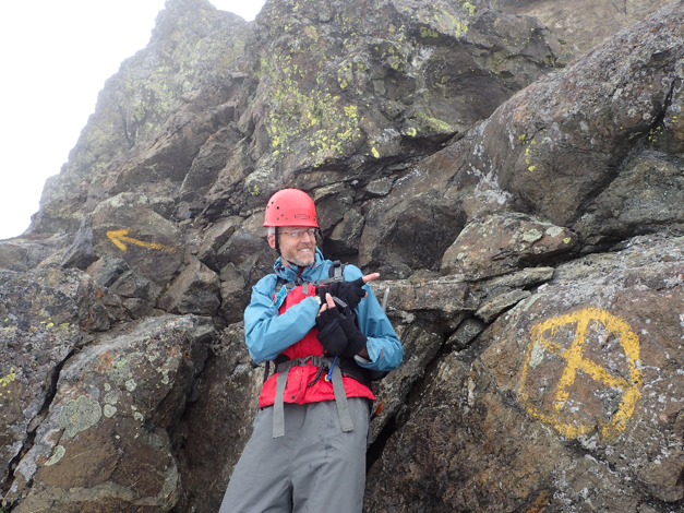
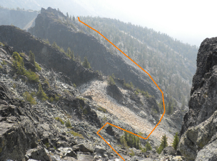
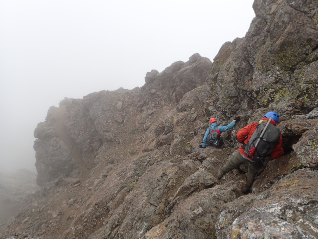
There were spots where it would be difficult for people not used to picking up scramble trails to follow but for the most part it was a ‘follow the path of least resistance’ type of deal. There were numerous cairns on the trail as well. At around 7,600ft it became more of a scramble in my mind. There were some loose sections so parties should be careful about rock fall. It certainly wasn’t the worst I’ve ever seen but it was loose enough caution should be used. So as you approach the first rocky outcropping along the ridge the trail tends left (west towards Ross Lake) and traverses under the outcropping until it intersects a rib. Here we turned right, uphill, and scrambled up a dirty gulley. At the top of this gulley there was a solid rock section that was somewhat slabby but was broken up enough that it was easy to scramble along that. Dave and Mike scrambled to the left of me in a dirty loose section. I recommend the rock. If it was wet, however, the dirt would likely be preferable. We topped out on an ‘arm’ of sorts looking into a large upper ‘amphitheater’ of sorts. We turned left (north) and walked/scrambled down a ramp and around to get into it. It was here we came across our first spray painted yellow signs on the rocks. This ‘amphitheater’ or sorts looks imposing at first but careful looking around can limit the route to 3/4th class scrambling. It looks like from the center of this theater some groups went right to the eastern side and attempted to cut up and back to the center via a ramp. We opted to go left to the western most side (saw a cairn this way) and then cut back right on a ledge to towards the center. From here we used a series of ramps and gullies staying mostly in the center or to the left (west side) of mountain. There are, I’d estimate, about 300ft of 3rd to 4th class. There was a little exposure. It wasn’t extreme but a fall would likely result in injury or worse. But again it is only for a short 300ft vertical of ‘trail’. After that, at about 7,900ft the grade begins to lessen and we ‘topped’ out in a cloud on what I thought was the summit but turned out to be a false summit with some old lookout looking debris as well.

So in the cloud, which occasionally snowed lightly, we walked over to the summit. From the false summit the trail is once again obvious and we followed that over to the true summit which is clear due to the 7 foot pole sticking out of the ground. Hooray! We had started to get worried on the way up because of the light snow and moisture on the scramble portion. We didn’t stay too long on the summit. Dave briefly looked around for a summit register, which was never found, had a quick bite and snapped some photos before packing up to leave. But even in those fifteen minutes or so I started to get cold and had to pull out my primaloft jacket. It was actually good that I put it on because the wind was really blowing up high (and most of the way down the ridge) and it remained chilly. Scrambling down proved to be easier than I’d expected. Fortunately it wasn’t really wet. There were a couple sections with a little bit of shist which would have been unpleasant when wet, but nothing too serious. We also encountered two serious eye bolts that had been cemented into the route. I suspect at one point there may have been a hand line or cable for the lookout workers.
Once back on the ‘trail’ of the ridge we were able to cruise out pretty fast. Crater teased us occasionally by showing us blue sky and then being engulfed in clouds again. At one point Dave said somethingabout going back up to try and get the views to which Mike and I both said it was unlikely we were going to get up there and get better views. So Dave said he’d just come back some time to get the better views. Then he asked us if we wanted to scramble over to the second lookout which was another two thousand feet of gain from the lake. Mike and I again, were the naysayers and opted to get back home at a reasonable hour. We stopped at the lake and had a quick snack though and that’s when the controversial topics began. We started on gender in the mountains and worked our way to politics. Kept it interesting on the descent. But both Dave and Mike are too nice to allow it to get out of hand so I think we were safe from everyone but me!
As we passed the tent just below the lake I yelled ‘Housekeeping’ just for fun! We didn’t really stop for the rest of the descent. There were a lot of switchbacks going down and it seemed to take a while to lose all of that elevation we’d gained. I kept watching our progress in comparison to the ridge opposite us and then finally the trees near the river to see how close the tops were getting. We made it back to the cars around 6.10pm. Mike had chips in the car. Hooray! We didn’t really stop for food on the way back but in Oso I called for a mandatory car break. I felt like Mike was really getting tired. He said he wasn’t but no harm in a quick stop at the Oso gas station and general store. It was actually really nice! Mike got licorice ice cream which turned his lips black and Dave got an absolutely massive caramel ice cream cone! I nibbled on the salt and vinegar chips. So all in all a healthy stop. And then Dave switched to the driver’s seat and we rode home listening to some Louis CK skits. All in all a successful trip.
Passes/Permits –
Requires a Forest Parking Pass.
Trail Conditions –
Quite a few downed trees and little brushy on the lower section but overall in good condition.
Objective Hazards –
Little 3rd possibly 4th class scrambling for about 300ft.
Gear –
Helmets, crampons, ice axe. Only used our helmets. Aka ‘brain buckets’ per Dave code.
Water –
A river in one spot on the way up and a lake at about 5,800ft. Above that it is snow melt or run off at the moment.
Animals –
Nothing! Excepting creatures of the humanoid persuasion.
Bugs –
A few mosquitos.
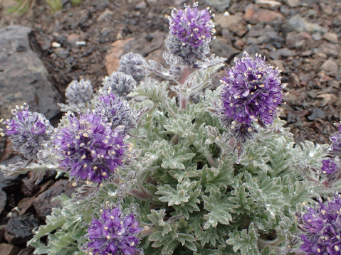
Flora and Fauna –
A few ground flowers but not much is blooming right now.
Lessons Learned
- Time to bring bug repellent once more.