
Tupshin (8,320ft) and Devore (8,360ft) and Flora (8,320ft)
July 4-7, 2013
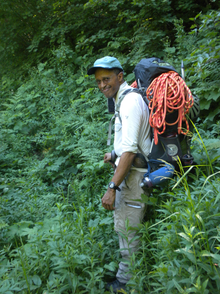
Linsey Warren
John B.
-- Day 1 --
Arrive Stehekin – 12.00pm
Arrive Weaver Point – 12.45pm
Bird Creek Camp – 3.40pm

Basin Camp – 6.00pm
-- Day 2 --
Depart for Tupshin – 5.30am
Base of Tupshin rock – 8.00am
Tupshin summit – 11.45am
Basin camp – 3.00pm
Depart basin camp – 3.30pm
Upper lakes – 5.00pm
Devore summit – 7.15pm
Basin camp – 10.00pm
-- Day 4 --
Rise and Shine depart – 5.00am
Tenmile Pass – 7.00am
Holden Village – 9.15am
-- Day 3 --
Depart basin camp – 6.00am
5,400ft camp – 12.00pm
Depart 12.30pm
Fourth Col – 2.00pm
Flora summit – 5.30pm
Fourth Col – 9.15pm
5,400ft camp – 12.00am
This trip just had so much to it I’m not even sure where to begin. Originally, John and I planned on climbing Dark and Bonanza but due to mine remediation and potential thunderstorms during the crux of the trip so we quickly redirected (literally on the car ride up) and went for the Tupshin, Devore and Flora traverse. We had four days and that seemed like a push, especially considering this ‘mine remediation’ meant that we absolutely had to catch the bus at 10.45am from Holden Village to get the ferry out of Lucerne to get home because the road was closed and it didn’t run on the weekdays.
So on the drive up we decided to head for the traverse, we bought our tickets and then ran quickly into Chelan because I needed some bagels and pop tarts. We dashed back to the ferry, parked the car and boarded! And per our usual luck I ran into someone I knew. Gretchen Lentz and her friends were headed out to try Flora! And funny enough as we got talking we got onto the subject of how to get to trailhead from Stehekin. The standard way is to catch the bus up the road and then hike back three miles towards the Weaver Creek Trailhead. But it was hot and we had heard rumor that sometimes you can convince someone to ferry you over on their boat to the campground. When we got into Stehekin we asked around but no one seemed interested or able and being the fourth of July weekend people were more interested in other things. John and I kind of gave up quick since the bus was going to leave in fifteen minutes and the next one wasn’t going to leave for two hours. So it was catch the bus or take the chance of trying to get a boat ride and potentially save time. So when it looked like we weren’t going to find someone we hopped on the bus. Three miles is just three miles after all. But when it looked like Gretchen and company might have found a ride we stalled the bus driver to find out and the poor guy was waiting while we tried to figure out our situation. As it turns out Phil had found a guy that would ferry us over to Weaver Camp and drop us off. So we grabbed our packs and ran off the bus while John yelled ‘Keep the money’ at the bus driver. It was like a scene from a movie. And as that happened I cut my finger on something and it started to bleed. Right out of the gate! First blood!
This nice gentleman (Adam?) filled up the lower part of the boat with all of our packs and we all squeezed onto the back benches. Combined we donated $60 to be ferried across and saved hours. We didn’t fully appreciate how much it had saved us until we started going up the dusty switchbacks from the lake in the hot midday sun. And then we were blessing Phil and Gretchen’s group. When we got off the dock I had to put a bandaid on because the little cut just kept bleeding! Then I changed into shorts because I was looking to get a little sun on my casper shade legs. We packed our bags and said our adieus and headed off. From the dock at Weaver Point follow the signs northwest towards the Devore Creek Trail. It heads up a little into the hills and then follows old power/telephone lines for a ways until it crosses a river on a log with a handrail and shortly after that (heading north) there is a sign on the left hand side indicating the Devore Creek Trail. From here we followed up the steep switchbacks towards the mountains. This trail gains elevation surprisingly quickly. Shortly after the trail heads back towards the river it becomes very brushy and the trail is a bit uneven so what underfoot. It’s fairly straightforward but if it became more overgrown it might be hard to follow. I had to stop and put my pants back on because my legs were getting scratched and itchy. We followed the trail for about four miles until we hit the Bird Creek camp sites at about 4,250ft. It’s a nice little campsite. We stopped and enjoyed the momentary clear space and pumped water from the creek before heading uphill. We originally headed uphill into the brush on the north side of the creek (climber’s right) and it was fairly straight forward for the first several hundred feet but we ran into brushy sections and the tendency was to keep moving farther north (climber’s right) which worked okay we just ended up having to traverse some steeper cliffy sections. It had clearly been done before as we came across a cairn. As we traversed back to the south (climber’s left) to get back to the basin between Tupshin and Devore I whacked my knee (same knee that got whacked on Buckner not a week before) and it hurt intensely. At this point we were hot, tired, bleeding and frustrated and the mosquitos were starting to come out. And since it was getting later in the evening we decided to continue on and head to the basin. We traversed around the edge of the cliff band into the basin between the two and made camp at about 5,800ft. There aren’t a lot of flat places in the meadow so we just threw our bivies out. I wasn’t too excited to get bit by mosquitos and was not having a good afternoon so John let me crawl into his hooped bivy and he pumped water and got dinner going. It was a nice birthday gift! As it was my birthday! So I iced my knee with a bit of snow John found in a patch not too far from where we were camping.

We called it a night early but I really wasn’t too keen on sleeping in a medium height grass slant with no mesh on my bivy – who knows what would want a cuddle in the night!! So John and I decided to see if we could fit two people in his bivy. We actually did get the thermarests in and us with our sleeping bags but it was a bit of a tight squeeze and I woke up a few hours later with my arm numb because the fabric had been pulling so tightly on it. Time to get up and get into my own bivy – experiment over and I just wanted to sleep!! We set the alarm for 5am or so and got moving at around 6am. From the basin we headed almost immediately north up the meadowed slopes. It is fairly straight forward picking a line up and the brush thins after a short period of time. After the massive bushwhack of the day before this wasn’t bad at all. We followed it until we intersected the southeast tending arm off of Tupshin at about 7,200ft. We crossed over the ridge and ran into our first solid patches of snow in the traverse over to the southeast basin of Tupshin. We tried to kick steps without crampons but that early in the morning it was still a little crusty so at about halfway across the traverse into the southeast bowl we put on crampons and booted up to about 7,600ft where the snow ends at the base of a steep rocky face. There are several ramps that head climber’s right. We took the middle ramp which inclined up towards a tree at the base of a chimney with a small chockstone. We scrambled up this chimney and then decided to leave my pack behind. From here we roped up and headed up short steep rocky sections and then veered right when we hit a ramp. Although the ramps often headed towards a corner the scramble route often did not go around the corner. So in this fashion we continued upwards until we hit a quite steep looking section that was near the upper right (east trending arm) and that is where you can go straight up or traverse around the somewhat exposed corner. Both end in a similar spot it’s just that the corner puts you out a little higher, which is what we did, and we had to scramble down a little gulley section to get back to the scramble section. In this case the ramps traversed back (climber’s) left and up to the base of another chimney. This is where the low fifth class section is. It’s not too bad I didn’t it in my mountaineering boots. After this chimney the grade lessens a little and we continued climbing straight up. One full pitch brought us to the upper ridge section. From here the easiest way may be to scramble the eastern ridge up to the summit. We, however, followed another chimney as it didn’t feel exposed and it was about a half a pitch to a three quarters of a pitch up loose rock to the summit. This cleft/chimney we followed brought us out right between the notch in the summit. Lovely. The top was really loose. As John was coming up I had to yell ‘Rock Rock Roooock’ at least once or twice as they were knocked loose by the rope.

Since we were planning on doing Devore this same day we only had a quick bite and then got ready to descend. I must say I wasn’t overly excited about descending since it was a bit loose. But on the way up we had passed several rappel areas which helped us know which way to descend. So we made several rappels back down. There were a couple goofy rappels where we started in shrubs and all our gear got caught on stuff. John got half caught in some shrubs on his way down and I had to laugh but it wasn’t as funny when I went and the whole rack got caught all over the trees! We rappelled to the base of the route and scrambled the last section back to the snow. The snow was fairly hard still, surprisingly, so we put our crampons on and started walking down. It was quite steep for a bit but the run out is fine so we headed down. I had my ice axe in my hand and a piece of poptart I was eating in the other and I slipped as I was scooting half down face forward and had a chunk of poptart in my mouth. I started sliding so I went into arrest and stopped after about 10/15 feet. I got up and looked at John and was like ‘Did you see that arrest?!’ and he was like ‘She didn’t even drop her cracker!!’ referring to the fact that I just slid and kept the poptart in my mouth. I was proud of that! I slipped and went into arrest but I didn’t lose any part of my poptart! Shazaaam! That’s how it’s done! It happened once more that I slipped and went into arrest so I took off my crampons which were balling up and plunge stepped down the rest of the way back to the ridge and back down into the basin. We arrived back in camp at around 3pm. We knew we wouldn’t have time to dolly around a lot so we refueled on water and snacks and about thirty minutes later we headed out. Although it was funny when we arrived in camp John noticed that the spare two liter bag he had filled was half empty. And we have no idea why it was half empty unless a critter came along and had a sip and put the lid back on. Other than that it showed no signs of having been chewed on.
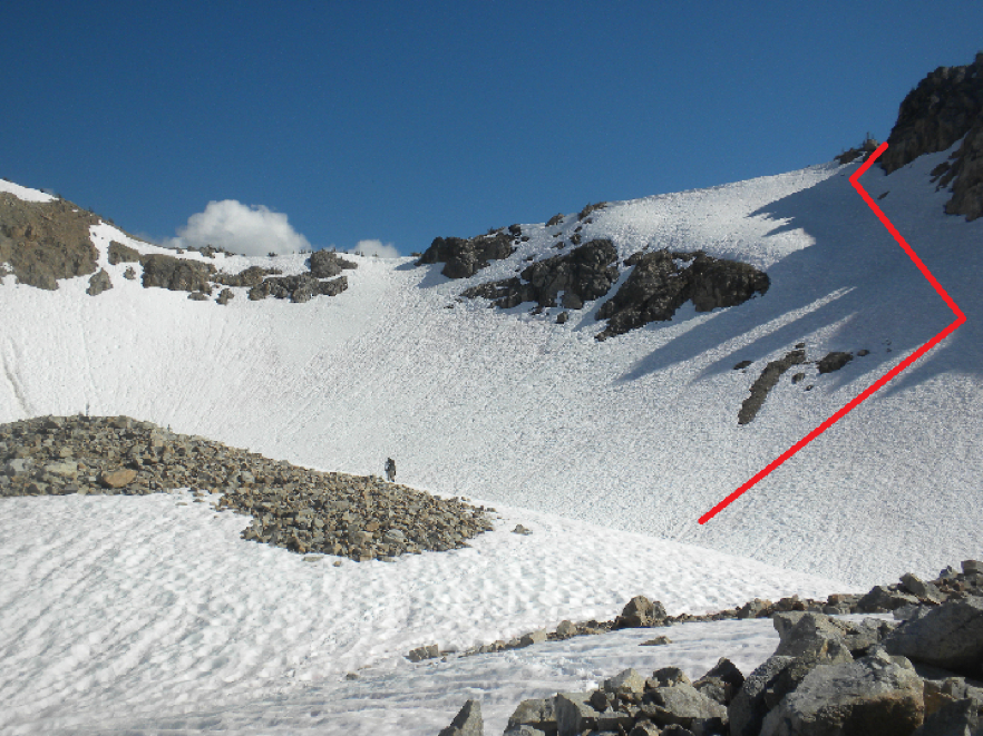
From our camp in the basin at 5,800ft we headed immediately south up a snowy ramp (will be rocky and scree when melted out) until a basin immediately to the north east of the lakes. This is the correct way – not via the waterfall on the northwest side of the lakes which we thought about for a moment. From this scramble we worked our way up and to the highest scramble point and then worked left through a small lightly treed section at the base of another higher basin. From this basin we scrambled up the scree and snow to the upper rim (there are trees up the center) and this put us out at the northeast side of the lakes at the base of Devore’s north side. From the lakes we worked our way up the snow to the ridge. We did not head to the lowest point on the ridge because it looked steep and like it might have a small cornice still on the top and to the right there was a rocky notch so we headed for that. The snow was fairly good consistency and John kicked steps up. I was starting to feel the day at this point and we were still carrying the rack and rope as we had heard that people rappelled off the top of Devore as well. From the ridge we travelled west along it. The top was fairly easy to traverse but we did have to drop about 20/30 feet below the ridge on the south side and scramble along scree for part of it. It is fairly straightforward just follow the ridge until it hits a large darker shaded hump on the ridge. From a ways off it looked unclear how we would get around but as we got closer we realized all we had to do was hop on the snow to the climber’s right (north) and scramble around the dark knob. It was easy and straight forward and not exposed. We hopped off on the ridge on the other side and traversed over to a gulley and up the gulley. It’s a bit loose and rocky here but not too bad. Once we topped out on the gulley we could see that the ridge turned northwest and what looked like the summit. It’s a fairly straight forward class 3 scramble over to the ‘false summit’. Just below the false summit there is a class 4 possibly with a couple class 5 moves to get up to the next scramble section (its only about 20-30 feet). From here I belayed John up and I scrambled up to what I thought was the summit but as soon as I got near the top I could see the true summit was northwest behind this one. It looked hard to get to at first so I back tracked down and John came over and looked and saw a ramp around the corner. So we rounded the southwest corner and followed a ramp over to the base of the actual summit. From here we roped up again and I led up the class 4 potentially class 5 (with boots on) little section. But there looked to be a gulley around to the southwest of the summit that could be scrambled without a rope.
That being said once we topped out and it was getting later in the evening we decided to snap a couple pictures on John’s phone as my camera had been left behind at the original step/rope up to the false summit. After the photos we set up a rappel to rappel the 80/100 feet back down to the notch between the two summits and from there we followed the ramp back around to the step before the false summit and rappelled back down to the scramble section. We packed up our gear and wasted no time hauling off as the sun was going to be setting very soon. We followed our tracks back down and my knee started to act up. Not the one that had been bashed in the day before but the other one. Okay. Weird. But no time to fiddle around. We followed our route back the way we had come up and made it to just below the lakes when the sun set and darkness moved in. I was scooting on my butt on the snow where I could to avoid using the knee but the last bit we had to do scramble down and in the dark we got a little bit off and bushwhacked around through bushes we hadn’t been through on the way over just to cross the stream/river to get back to the camp. And we made it! And this time John’s rock shoes were laid out on the ground where he hadn’t left them. Mystery remains. Our camp got moved around a little. Im still not quite sure how. There were deer milling about all day that weren’t scared of us so maybe they rooted around a little? Either way I’m not sure. But we were pretty darn tired once we got back into camp at around 10pm. We pumped water and made some mountain house dinner before we crawled into our sleeping bags and tried to sleep. But for the second night in a row we didn’t get great sleep. Odd but at least the stars were gorgeous.

The next morning it was hard to get up and get moving but we had a long day ahead of us and I was concerned my knee would hurt enough that we’d have to turn around and head back to Stehekin to guarantee we’d make a boat out. And neither John nor I had any or a lot of drugs. I had a couple packets of Tylenol but that wasn’t going to be enough if it got real bad. So we bushwhacked back towards Devore Creek trail. This time we made sure to head straight down following closer to the Bird Creek River. It was a bit steeper and brushier but overall it went fine. John might say otherwise since he had to go first to clear the spiders and climb through the slide alder. Once we regained the trail it was like throwing a small party. We came out right at the campground which was awesome because that’s just about as clear as the trail got. We had a quick break and then continued to follow the Devore Creek trail uphill and south. We had to ford a small creek/river at one point by taking off our boots and wading across. It was actually a good wake up call for my feet. After that we followed the trail for a few miles until we intersected the topo at 5,100ft where we had read there was camp to stage out of in order to get to Fourth of July Basin. We never came across a camp and we had a hard time distinguishing basins because all of the maps intersected or were broken up right in this area and the information we were reading just wasn’t great. The whole trip the beta was kind of bad. John and I talked about providing better beta but at some point John said that we shouldn’t that everyone else should have to suffer like we had! And that is probably why it has remained like it has for so long.

At about 5,500ft we crossed the Devore Creek River. We had to cross a little higher up the river as the water was a bit high and there was no easy way to cross. We still got a little wet but it worked fine. We made our way back to the main trail and found that right on the other side of the river crossing was a great campsite. We decided this was it. Drop our gear and make this our staging ground for Flora. It was just about noon when we arrived so we stopped and pumped a little and dumped our gear. It was bushwhack from here up to the Fourth of July Basin (which was northeast traverse around the base of an arm into the basin. At one point John was crawling over a log and snapped off a branch that was dead and yelled ‘This is how I feel about this trip!!!’ as he threw the branch down on the ground roughly. We bushwhacked (same slow annoying going) up until we hit a rocky boulder talus basin and then continued up that until we topped out at the col at about 7,200ft. In this Fourth of July Basin we must have hit some sort of limit because everything was cracking me up! I couldn’t stop giggling and laughing. Just looking at John’s broken up pack with broken straps and wholes all over it (mostly from this trip) to stilly random thoughts floating around my head. We sat down and I just giggled. John told me it was better than crying. Haha I guess that’s what it was.

From this col we thought we could see Flora but you actually can’t you can see Point 7,734Ft. The summit is northeast from the col so up the climber’s left. There is a small looking boot path that could carry up and over to the ridge but we weren’t sure and there wasn’t a lot of information so we dropped down and traversed around at about 6,900ft. Once we rounded the corner we decided we would head back up to gain the ridge because we weren’t sure where we were or where we were going! We gained the ridge and then seeing as it was already since it was already 2.15pm we were questioning whether or not we should continue. The ridge was long and it was going to be a long traverse. We decided to have a 4pm turn around and go as far as we could and if we were within striking distance we would go for it. So we literally flew like the wind around the ridge until we were about a third of the way between Point 7716 and Point 7734 and that is when we realized that the ridge was going to take too long if we were going to follow it. The quickest and easiest way for us at that point looked to drop down into the valley and then up Flora via the southwest slopes. So that is what we did. We plunge stepped into the Castle Creek Basin and then up the steep mostly open but treed slope to get to the plateau below Flora. It was a bit of a steep scramble in one or two spots but presumably if one were to work around further to the north it’d open up into a wider gulley. Either way straight up to the plateau from the basin at 6,600ft worked fine. Once at the plateau the snow tapered off a bit and it was mostly a melted out scree fest to the top. It wasn’t the works but it was still scree. So John dropped his pack and we combined into one. From the base of the plateau it’s only about 1,000ft to the top.
So we scrambled up as quickly as we could. At this point after the long days we’d put in I was really feeling this and I periodically had to stop and take a breather. John joked that it was like going up Everest and we were doing the rest step. So I jokingly made loud breathing sounds like an oxygen mask and that’s about what I had the energy for. We scrambled to the top. It’s an easy scramble of class 2 or 3 to the top. Once we got there we took some photos and I added some cold water to our Mountain House Chicken Salad. I was starving and kept feeling sick because I needed water and food. But as I started to munch on the mix a giant spider crawled across a rock near me. Not funny. I scooted off and told John if it came back it’d be a problem. Of course it came back so I scooted right up next to John. We didn’t dally about long and John carried the pack on the way down. We hadn’t finished the chicken salad, really we only had a few bites but we were wiped and it was getting late. So I stashed the remaining chicken salad in the pack and left. We had made the summit around 5.30pm and we left around 5.50pm. We followed our same tracks back and it felt so surreal. We were tired and there was still sigifnicant ground to cover to get back to where we had dropped our gear. So we went down into Castle Creek Basin and back up to the ridge and instead of following the ridge which was time consuming we dropped down into the upper Riddle Creek Basin and around to the col catching up with our original steps at around 6,900ft where we traversed.
The sun was setting and we were trying to get as far down as we could before it become totally dark. But we knew we were going to be doing the bushwhack in the dark and that wasn’t sounding pleasant. We made it to the Fourth of July Basin upper col as the sun set and we glissaded down the upper portion to where it was sections of talus and snow and walked back to the original boulder field where we had entered. At this point it was totally dark and finding our way was by headlamp. We headed into the brush and started making our way back. It felt abominably long. The great thing about John and I as a team is that when one of us is tired or dragging usually the other has enough energy or momentum to keep the team going and this is where John picked it up and went first on the bushwhack in the dark but his headlamp started dying. Of course. So we stopped in the cluster of bushes and tried to change out the batteries but we couldn’t get the headlamp open and we were at high frustration levels already. And with thunder and lightning just north of us we were ready to keep moving. So I gave John my headlamp and I used his slowly dimming one on the way out following in his steps. We got cliffed out several times and had to make our way. And as we went the GPS showed signs that the battery life was running low. Oh great. What else?! Well as it turns out the what else showed up not too long later when I looked down at John and said ‘Where’s your gaiter?’ and he looked down at his leg and noticed it was gone and he looked back hopeful for a moment and then said ‘It’s gone’. The straps had gotten banged up and broken earlier and I guess the brush just ripped it off. Our backup plan was to make it to the river and then traverse back to where we thought camp would be about. It wasn’t ideal and we did make it back to camp before the batteries died. Praise the Lord. But it was midnight when we made it back. I told John I wasn’t going to cook anything or pump any water I was crawling into my sleeping bag and going to bed. It was a twenty hour day and we needed to be up in four hours to hike out to try and catch the Holden bus. I tried to have a snack of the chicken salad and whatever else I could scrounge up cold but the chicken salad had exploded in my pack… awesome. I’d be lucky if animals didn’t come savaging around in the night. I crawled right into my sleeping bag and passed out. I didn’t sleep that great and I kept waking myself and John up with my incessant babbling. Apparently I was talking about 10.45. Go figure.

We woke up as the skies were grey and there was little light but we were exhausted so we slept in another thirty minutes. But after that we got up and packed up and headed out. We followed the trail for a little while until we crossed a creek and right after we stepped over this tiny creek we lost the trail in the snow and brush. Crap. John and I just did not have time for this. We searched around but we couldn’t find the trail so we headed off in the direction we suspected it might generally go and hoped that we’d intersect it at somepoint other than that I guess our plan was to bushwhack to more open terrain? I don’t really know. It was an exhausted hope and a prayer at this point. Thankfully we intersected the trail and it carried us up and over to Tenmile Pass. We descended off the pass and realized we just weren’t losing elevation that fast and we wanted to be extra certain that we didn’t miss the last bus out of Holden (aka the last plan out of Saigon). And because we weren’t seeming to gain ground that fast we started doing a slight jog downhill. John yelled ‘double time’ and said he felt like he was in the military running with a full pack. So I gave him a good couple hooouu hooouuu’s! We worked our way down to about 5,000ft which is where the trail gets rougher but right now it is currently well marked with blue flagging. So it’s easy to follow. We were expecting the hard part of the trail to be between 4,700 and 4,300ft where the trail does not appear on the map but actually that was okay. The only real issue here was that we had to cross a river and we didn’t want to take off our boots and it was quite wide and fairly deep in some spots (perhaps a foot and a half two feet) so I put on my gaiters and ran across. Later in the year I suspect this is not so much of an issue.
From 4,700ft we easily followed the trail down. We ran into our first people about a mile and a half from the town of Holden right after John got a tremendous cramp in his leg. He was limping and struggling to keep walking. We were officially approaching ‘mess’ status. As we descended our back up plan was to cut straight to the road if we had to and run in front of the bus! But since we could hear the giant construction machines in the valley from halfway up to the pass we did think twice about running onto the mine remediation road. We hustled to Holden but my feet felt like they’d been beaten with a stick and I could barely walk but we had to get there before we took a long stop because otherwise it’d be hard to get going again. And at long last, we walked into Holden Village. It was a ghost town because of the mine rehabilitation so we made our way to the registrar and paid for our exit out of the town. We had missed breakfast by 15 minutes. Bugger. So we stumbled to the front of the building and dropped our packs. I pulled out some of my gear to dry and pulled off my boots to let my trenchy feet dry out a bit. As we sat there these aggressive little chipmunks ran up and started chewing on my pack! Little blighters! They actually found an already partial hole in my hip pocket that had a small whole in the gorp bag and really made it a treat. We couldn’t keep them away. We heard tales of how they’d come into town and steal the food of your plate. Awesome. So we arrived in town at 9.15am and waited for about an hour and a half talking to the people in town and learning about the mine rehabilitation while our stuff dried out. And we had to laugh at the state of John’s clothes on the trip – his whitish gray shirt was just an unrecognizable shade of dirty!! And his pants had smears all over them. He had changed into a new shirt for the way out. A courtesy shirt. I was in my courtesy shirt too but was in a similar state of just dirty.
I started to doze off in the middle of the walkway. John told me I should probably be mindful of the people but honestly it was the best spot and there weren’t that many people! We were two of the five people that road the bus down. We made friends with them and continued to chat while we waited the couple hours for the Lady Express to arrive. When we boarded there was a trail of gorp on the gangplank to get on… guess who’s pack it was from? We got on and I pretty much passed out. I was out for what I’d guess to be an hour. It was so hot. And on the ride back we learned that on the fourth of July a fire had started out near Chelan. Once we got back to the dock we quickly grabbed our packs and got off and headed for the car. As we crossed the main street and headed up to the car holding area I tripped over my own shoelaces that had got caught on the metal clasps on the shoes and since I didn’t have any straps on the pack done up the pack went up over my head and I went down onto the pavement. What a way to end the trip. But in some ways it made sense. We quickly changed and headed into town for a snack and on our way in we ran into the same fellows who caught the bus with us from Holden so we picked them up and dropped them off at their car in downtown Chelan and we decided to join them for pizza. John and I got their first with just enough time for me to knock a glass of ice water all over the table before the other two gents arrived. We had a lovely lunch/dinner before we got in the car and headed home! The trip felt a lot like a dream. Several times John and I commented on how surreal and fast time moved. And to lend even more to the surreal factor John kept calling the peaks those peaks we climbed. Haha I don’t know if he remembered them the first couple days. But by the second or third day he had come up with a new name for Tupshin – Tupshit which turned into Tough Shit. And then John came up with Devore as ‘Devour Me’.
Trail Conditions –
I don’t even know where to begin with this one. The trail was clear in some spots and disappeared under brush and other debris in other places. Overall it was okay to follow but in several sections it was hard to follow.
Objective Hazards –
Rockfall, navigation, lightening and general exhaustion. There were a couple small river fordings. If it was during the heavy meltout time of the year the rivers may be hard to pass as there are no bridges.
Gear –
Rope, rack, 2 pickets, crampons, ice axes, harnesses. We did not use the pickets.

Water –
There was plenty of water for the majority of the trip as there is still enough snow melting that being said later in the year without any standing glaciers for melt off there might be a limited supply. The last 1,000ft of each peak had virtually no water supply.
Animals -
Lots of deer!! My goodness! Also the sound of whistling marmots and some aggressive little chipmunks in Holden.
Bugs -
Yes. Mosquitos, spiders, and a wide variety of other flying insects. One of which I swallowed so we’ll never know about that one.
Flora and Fauna –
Flowers were starting to appear lower down. Lots of glacier lilies.
Lessons Learned
- It’s hard to drink enough water.
- Two people can fit in John’s bivy in a real pinch!!
- John and I make a good tired/powered duo! When one is tired the other helps push on!
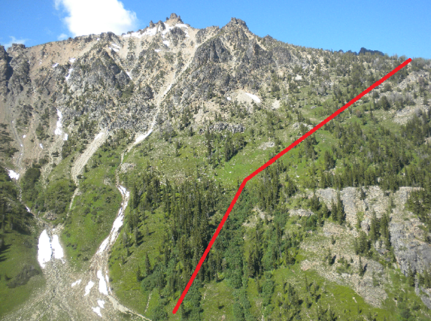
This is looking up the South side of the route to the 7,200ft arm on Tupshin.

Approximate route up - real approximate. It looks very different while on the route!

Looking up the scramble route to the lakes below Devore.
Looking up from just east of the lakes towards the ridge at about 7,400ft.

Looking northwest along the ridge towards the summit after topping out on the gully. This is the false summit that is so tempting. Go around the corner and the true summit is immediately after.

Looking up the Fourth of July Basin.
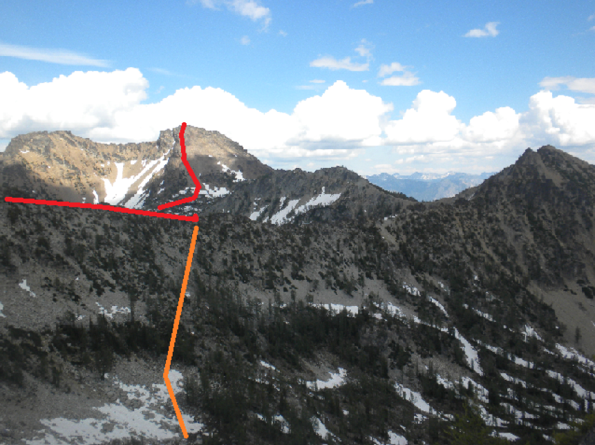
The red indicates where we followed the ridge and dropped down into Castle Creek. The orange indicates where we dropped back into Riddle Creek upper basin to save time. This was taken from around the col. It was about 20/30 minutes back at this point.
