
Mt. Baker via Easton (10,781ft)
June 4-5, 2016
Linsey Warren
Kyle Finnegan
Andre G.
Laurel T.

-- Day 1 --
Meet Brickyard P&R – 6.15am
Arrive Trailhead – 9.00am
Depart Trailhead –9.30am
Railroad Grade – 12.00pm
Summit camp –8.15pm
-- Day 2 --
Rise and shine – 4.45am
Summit – 5.30am
Railroad Grade (top) – 10.00am
Arrive Trailhead – 1.00pm
Arrive Brickyard P&R – 4.00pm
**All times are estimates as camera time may have been incorrect.
One month after being on Baker with John and Duncan for Colfax and Sherman I found myself back on the mountain but this time with Kyle, Andre and Laurel. I went back and forth on which route to take. I’m quite familiar with the Coleman side now and I believe it is technically shorter but the difference between the routes didn’t seem too substantial and so I opted for the Easton glacier so that I could see another face of the mountain. Literally and figuratively.
The weather was shaping up to be perfect, albeit a little hot. I sent out a pre-climb email with basic gear distribution and links to two different weather forecasts and The Mountaineers basic route description. We met at the Brickyard, ‘aka Boneyard’ when Dave and I are meeting, at 6.40am. It was supposed to be 6.30am but we were running a little late because I couldn’t find the Northwest Forest Pass at the last minute. Fortunately for all Laurel had an America the Beautiful Pass which I just learned this weekend can be used in place of a Northwest Forest Pass. Although I asked everyone numerous times whether or not they thought it’d work. Andre told me he read it on two sites to which I asked “Reputable sites?” Everyone was ready to accept it worked, I was just nervous since the parking fine can be pretty hefty. But fortunately it did work, and now I’m seriously considering an American the Beautiful Pass!
Overall we made good time getting there, with one quick stop at the Starbucks in Sedro Wooley for a late breakfast. We followed Hwy 20 East until just after *Hamilton and then turned left onto Mt. Baker Road. We followed the road for a ways before turning left onto Forest Service Road 12. There was one sign that indicated Forest Service Road 12 and then after turning onto it there was minimal signage until the fork in the road for Road 12 and Road 13. We took the right fork and continued up FSR 13 to its terminus at the trailhead. The parking lot was full so we had to drive a little ways down the road (not too far) and park on the side of the road. There were lots of guiding vans among the numerous other cars. If there was any doubt that it was going to be busy that settled it for me.

As we were heading off out of the trailhead we ran into a group of individuals who looked like they were there to day hike and they asked if we were going up the mountain and if this was the start of the route to climb Mt. Baker. I always enjoy interacting with people who are curious about the mountains; who are exploring a new place and excited to hear more. It always seems so positive and encouraging. But perhaps that’s just my passion meeting their interest in a perfect combination. The trail is straight forward and looks like underneath the snow it would be very obvious but we started hitting patches of snow about 300/400ft above the car. They were patchy so it wasn’t too bad but they were melting fast and had lots of opportunities to punch through to a hollow space below. Once we arrived at the river crossing I remembered reading something about a ‘’dangerous river crossing’’. Oops. Spring melt off. A guided group had gone across not long before us so that was a good indicator of a place to cross because at first glance it looked like we may have to take our boots off and wade. I didn’t see any obvious rock hopping spots. We ended up going uphill from where the trail intersects the river about 60 lateral feet and hopping rocks to get to a middle rocky section in the center of the river. From there we walked across two tiny logs laid next to each other pinned against a tree. The logs looked like they were barely able to hold our weight and were partially underwater in a couple places. The lovely guide woman across the way gave us encouraging smiles and pointed the way which was very kind of her. I went across first and only got a little wet but nothing substantial that seemed to penetrate the boots. Success. Laurel followed using one of my poles and then the guys followed immediately after. We didn’t stop we just continued across the way and upwards. The trail wasn’t immediately obvious and given the way we came up I think I inadvertently followed a stream up a short ways before intersecting the trail. It was just making it through the washed out river section. After this we encountered several more sections of snow and trail before reaching all snow as the trees opened up. The railroad grade rib was melted out on top so you could follow the trail but it was snow to walk across to get to it. We stopped shortly before the railroad grade in the shade of a lovely group of trees on a melted out platform that looks like it was made for someone to pitch a tent. We all had a snack, water and took in the views. Another group of two stopped on the other side of the trees and we invited them over to join us on our really lovely flat platform. We briefly talked with them before setting out again. We followed the snow to the base of the railroad grade and then took the trail up to the top and followed the trail up. The sun was really hot at this point and just looking at the glacier filled me with a sense of foreboding. It was going to be cookin’ hot on the glacier.

As we made our way up the railroad grade we saw two marmots just below the trail having a marmot fight. It was kind of sad because they were making sad squeaking noises but at the same time a little funny because they were holding out their little paws and batting at each other. The marmots looked more ragged than other marmots I’d seen. It was kind of sad. Hope it’s just them coming out into spring and their coats and health improve. We briefly stopped for a little bit of water for Andre along the railroad section (last bit of running water I saw until below the headwall). Just as we made our way off the railroad section to the first set of tents and the lower campsite Kyle’s leg started hurting him. He thought it was a mix of a cramp and a charley-horse. I admit to being frustrated at this point. We hadn’t gained that much elevation in relation to how much we still had to go and it made me nervous. He was able to pull it together though after we had a short stop. Since we stopped we also roped up. In hindsight that was premature. We could have gone another several hundred feet without roping up and not been on the glacier.
From the lower camp there is a rib that heads upwards the glacier. On the left side is the Easton Glacier and on the right side it’s a snowfield (though I suspect later in the year it may melt out). We followed the rib closely but stayed predominately on the left hand side until just before the last rock outcropping visible and then transitioned onto the glacier. It looked like a more moderate grade with footprints. Though I did note that another team was heading straight down on the left hand side of the rib and that looked like an easier path than the winding one we had taken crossing to and fro on the rib. The glacier is in good condition over all. There were some sections where crevasses where visible but nothing that wasn’t easily stepped over. In a couple spots the snow was melting out and crevasses were starting to become exposed underneath the path but again nothing that isn’t avoidable at the moment.
We did not need crampons this late in the day, it was quite soft. We also just clipped in with butterfly knots and eights on a bight on the ends so that we could unclip and switch positions as necessary which was nice when it came to switching it up for step kicking. There were no clear ‘uphill’ steps because it was getting on in the afternoon and lots of people had already descended obscuring and obliterating most uphill steps by all appearances. So for the most part it was almost easier to step to the side of the very large path and kick our own steps. After a while I got tired and passed off the mantle to Andre to kick steps and after Andre got tired Laurel kicked steps for a bit.

We passed another team on the descent and then saw a paraglider coming off the top of Baker! The team said that he was hoping to get as close to Bellingham as possible. How cool! And I tried to wait out having to go to the bathroom. I really didn’t want to stop until I was sure I could fully go. When that moment did come I took a party separation and thankfully it was a warm day because it took some time. We had a nice break complete with food and water. We also took in the rest of the route. Another party that had been descending mentioned something about an avalanche above us but I’d filed that away as unlikely to be a real concern. But when we got higher I could see what he was talking about. There was a slab avalanche not far from the boot path (the boot path was nearly 50 wide as everyone plunged stepped down and made their own tracks). The crown looked like it ranged from half a foot to a foot in height (estimate) and was fairly large. It didn’t look like it would have been deadly but it did end near a crevasse and that could be deadly! And as I looked around I noticed that it wasn’t an isolated incident. There were lots of slab avalanches all at the same elevation and there was one right below the headwall that was very large. The avalanches all took place at about the same elevation. I estimated that to be a bout 8,800ft.
After this break I had to remind myself that even though it didn’t feel like we were going fast we were in fact making fairly good time and we still had the rest of daylight hours to reach the summit which seemed reasonable. I took off leading and in an effort to avoid the other steps veered slightly left following an old set of footprints straight uphill. As I got higher I noticed there was a fairly big hole on the path. I suspected a crevasse where someone had punched through, walking a little closer, that suspicion was confirmed and I could see the indent in the snow moving laterally across the mountain and slightly downward. I moved downward along it and was nervous about crossing over it since someone else had punched through. I went quite a distance to the left and tried to sink my pole in several times before crossing. But it’s hard to tell exactly how wide that crossing is. At any rate it stayed intact and everyone made it across without incident. We then continued uphill to the crumbling gates near the crater rim before the headwall. I had told everyone we’d take another break at the rim. As we neared the rock outcroppings I could hear the sound of running water. I thought perhaps it was the crumbling pieces of the outcroppings but as we got closer realized it was in fact water running over the outcroppings and it was causing rocks to crumble off with it. There was a bit of a debris field around the base, most of it was baseball size or smaller. There rim ice was melting fast.
We stopped just below the headwall to the north side of one of the outcroppings near the moat around it to try and enjoy a little bit of shade. I had a hat on and over that I had my buff pulled up so it used the brim to pull out the buff fabric in an attempt to shield the sides of my face but I still felt like I was getting sun. It wasn’t much but it was a little cooler. The boot path up was a lot more consolidated here as people stayed mostly within the path to go up and down the headwall and the path cut nearly right up the center. As we moved along towards the center in a slowly rising traverse my gut was a little nervous. This slope was of a similar angle to the ones that had avalanched and it was still hot out. And according to other parties on the mountain they had avalanched this day. I didn’t like the idea of going up the exposed center, especially as the run out was directly towards crevasses so I posed the question to Andre, Kyle and Laurel. “Do you want to follow the steps up the potentially riskier but certainly easier center or would you like to take what I believe is a safer route up the side which will involve us kicking our own steps?” The consensus was to take the side up. I think in my heart and mind I knew it was wiser but I wasn’t sure I wanted to kick steps all the way up. I believe that these slab avalanches were a direct result of the snow that had fallen a week before (nearly a foot was expected when I’d totaled up the days leading up to and on the weekend previously) combined with the extreme heat of this next weekend.

It was soft at this point and going up my feet were sinking quite far and it was a significant amount of effort in the steep hill to pull my feet out far enough to be able to kick another step at a reasonable height. I had to stop to breathe a few times on the way up. I tried to stay as close to the right side ‘ridge’ as possible where the snow was intermixed with rocky sections. I was hoping to get to the snowy rocky section and walk along that but as I got close to it I discovered there were a series of large and fairly deep moats around the rocks. So I marked the area with a big X and yelled back to Kyle to be careful as he was next up on the line. He did get a little close though and had a hard time moving through that section and got tired out punching through some of my steps. So we briefly stopped and Andre traded places with Kyle so the rope went me, Andre, Kyle and then Laurel. So Kyle could have the chance of someone else reinforcing the steps. I started tiring out a little bit towards the top. Not that I couldn’t keep walking uphill but kicking the steps and having them break out was getting exhausting. But once we started to crest out on the top the snow firmed up a little bit and the grade relented so it was much easier travelling. That and we could walk in other people’s footprints once again. I think that everyone thought it was going to be a very obvious ‘summit’ after the headwall but there is a low grade uphill walk to get to the flat spot right before the true summit and at that point I think everyone was spent. I briefly unclipped from the rope and had Andre coil it to himself so that the other three could keep walking slowly and I could go scout out where we could put our tents. I didn’t want to drag them around looking for the flattest spot. We got up as the sun was low on the horizon and it was absolutely gorgeous. Even at the base of the headwall you could see the sound reflecting golden and the islands standing stark against that golden color as dark dots. It was quite beautiful.

I dropped my pack and briefly waited but didn’t see anyone and then thought I better walk back to make sure everyone and everything was okay. As I got about twenty or so yards from where I dropped my pack I saw them cresting over the top and yelled that camp was literally right there and pointed. I walked back with them and immediately dropped my pack and started using my feet to pound out a platform for us to sleep. As I pounded out a platform for Kyle and me, I also encouraged everyone to have a donut. I had carried them up as a breakfast surprise but I thought that everyone looked a little bedraggled and could use a pick me up. I tried just using a shovel to flatten it but the snow underneath was too soft and shoveling it off and then stepping there made me sink in almost further. So I stomped out a platform and then used the shovel to level it. I encouraged everyone to change into dry clothes as we got the tents up and asked Andre if he could get their stove going so we could start melting water. Melting water for four thirsty people and their dinners was going to be time consuming. It was partway through setting our tent up and our gear thrown in the lovely massive vestibule (our first time using the Hilleberg Nallo GTS) when I heard Andre say something to the effect of the stove wouldn’t stay lit. Bugger! I was glad that Kyle and I got the MSR XGK the night before and briefly gave it a try before bringing it. Kyle was able to get it going and we were able to make dinners for everyone but not fast enough! Laurel had eaten her food before we could even heat the water and went to bed shortly after. I only briefly heated our Tasty Bites Indian packet and didn’t bother heating or opening the rice. Andre was the only one who needed the hot water to cook his Kathmandu Curry Backpackers Pantry meal. And once we got the water in it he used it to heat his toes and then went back to his tent. The next morning he said he fell asleep before he could really eat anything that night. So needless to say the night of star gazing and chatting I envisioned did not happen. I manned the stove for a bit and tried to melt a couple liters of water that night so we wouldn’t have a ton to melt the next morning. Kyle’s feet were freezing so I tried to warm a little water in a bottle to give to him for his feet and we crawled into our sleeping bags. I watched the sun set low and blood red over the horizon as I finished up in the vestibule. The huge ‘garage’ vestibule was awesome to just throw gear under. It may not have been strictly necessary on the calm, relatively warm night we spent on the summit but it was still nice. I was fairly cold for part of the night so Kyle gave me his primaloft jacket to lay under my waist. It was the waist area where the cold seemed to be seeping in the most. Otherwise wearing my primaloft jacket and placing my down jacket around my toes kept me very comfortable.

Overall it was a calm night outside and the tent didn’t make much noise but it didn’t seem overly calm on the inside! Kyle got up to go to the bathroom, then I got up to rummage around the vestibule for a snack and a drink, then I got up to go to the bathroom and then at sunrise the sounds of people’s feet crunching along near our tent woke us up. I poked my head out and realized that there were quite a few people on the summit already. I yelled over to Andre and Laurel to see if they were up and if they were if they wanted to get moving. We had set our alarms for 6.00/6.30am or so but decided since everyone was up anyways and there were people summiting we might as well get up as well. Plus, in the back of my mind I wanted to get down as soon as possible because it was going to be even hotter today and I really didn’t want to be baking on the glacier in the noon day sun. I started melting the water and pushing donuts again. I would have happily eaten the whole container of mini Mighty-O donuts but had allocated 2 for each person that morning and a hot chocolate if anyone wanted it.

It was difficult to get everything packed up because the tent was so big it took up nearly one third to half of my pack and I couldn’t put anything else in it until I packed up the tent so I had to leave my stuff in a pile while we unpacked the tent. That did seem to be the one downside – besides the weight, it’s packability is more challenging. Once we got everything mostly packed up I grabbed the camera off my bag and we started walking over. Kyle was trailing a little behind so from the summit I yelled at him to go back and get the GPS! I’d forgotten it when we made for the summit. Oops. It was crowded on the summit, and the true summit isn’t that big overall, and today it was snow covered so no register to sign. We didn’t stay long really. Just snapped a few shots of the group and individuals and then turned to head down. We grabbed our packs and roped up from where we had camped. I wasn’t strictly planning on roping up so soon but Andre had flaked the rope and it wasn’t going to add too much on to walk roped up. There’s something cool about walking along the top where the sides start to drop off. It’s a slow curve so you can’t tell immediately if it’s a real steep drop off or a mellow slope. The snow was fairly crunching so we were wearing our crampons down (we didn’t wear them over to the summit – except for Andre) as they weren’t necessary. Since we were just a four man rope team we were generally able to move past a couple of the larger teams. I would move fast and then stop to take a picture. I was trying to get different angles of Sherman and the nearby routes for future reference. Move fast, picture! Move fast, picture! I’d brought a couple ice screws and we had three pickets just in case the headwall was icy at any point and we needed to set an anchor to belay or rappel someone, but it was in primo conditions that morning. It was firm but with all the steps it was a veritable staircase down and with the bite of the crampons it felt pretty solid. We certainly all moved at different speeds and rope management was a little bit of an issue because the person in front was almost always directly below of the person above and if we kept moving the rope would coil near the lower person’s feet. I did see the rope get stepped on a few times and it broke my heart when I found a snag in the outer sheath. Overall I felt really solid on it, but Andre and Laurel didn’t seem as sure footed. We briefly stopped near the bottom of the headwall where the path traversed back over to the rim between the two rock outcroppings to take off a layer. We were still in the shade and there was no need for a jacket. It was a very quick stop as people were coming down the headwall above us and I didn’t want to let them pass us. We then took off and didn’t really stop until we were on the moderate glacier slopes lower (aside form one chapstick and sunscreen pit stop for me but I tried to do that as we walked). Funny enough, as I stopped to grab the chapstick from Kyle I found a chapstick in the snow! Ask and ye shall receive. I took off at a good clip on the way down but we were definitely working at different speeds on the rope. Eventually after seeing a couple trips and noting how the snow was really softening I called for a quick break, a snack and crampon removal. And after that I switched places with Kyle so he was at the front of the line in the hope that he’d set a more reasonable team pace than I was setting. But apparently without the crampons everyone was ready to run. We went a lot faster for the last bit. In fact I was forced to run several times to keep up. Kyle led us all the way back to the rib above the camp (aka the sea of tents) where we unroped so we could get a few glissades in. While we did that, Andre ran into a few of his Everett Mountaineer friends, which was good since he was hoping he’d get to say hi to a few. When we’d talked earlier he’d made it sound like he might want to stay and visit, but once we were there and the heat of the day was picking up it seemed like everyone just wanted to go down!

We’d talked about stopping under our shady tree spot again but ended up stopping partway down the railroad grade trail where there was a little stream exposed (where Andre had gotten water on the way up) and he obligingly filled a liter for everyone. Sweet cold nectar of the gods. I threw in a Blueberry Burst electrolyte packet in for fun. I’d been testing different electrolyte packets yesterday and today and overall I think this one was the best.
The sun was fully up at this point and I was desperate to get to the trees. It was getting hot. We took several breaks in the trees to sit down and cool off. No real rush as we were going to get out at a reasonable time. However, the river was running higher because it was later in the afternoon (second hot day in a row). So I initially thought that the thin logs we’d walked across previously had washed away, but after some looking I noticed that they were mostly underwater. Unh. We were almost back to the trailhead, so if our boots got a little wet so be it. Fortunately mine didn’t get too wet. Two other gents followed us across. And after that it was smooth sailing and quick work to get back to the cars. When we got there the car was in the sun so Kyle moved it to a shady spot so we could let it air out and cool off in the shade while we packed up our gear and changed our clothes. We made it back to the car at 12.30pm (ish) which was between the noon and one o’ clock time frame I thought we’d make it! Glad to know my mountain math is still fairly good. We opted not to stop for food on the way home, aside from one pit stop at the ‘Mercantile’ off of Hwy 20 to get some drinks, chips, and a scary sandwich for Andre. We made it home in good time. Hallelujah!
Passes/Permits –
Requires a Forest Parking Pass. Alternatively we used an America the Beautiful Pass.
Trail Conditions –
Still snow on the trail going up to the ‘railroad’ grade section of the trail but it was melting fast in this extreme heat.
Objective Hazards –
Some crevasses (mostly snow covered) and one river crossing.
Gear –
Helmets, crampons, ice axe, 60m 8.5mm rope, 3 pickets and 2 ice screws (never used), basic glacier gear.
Water –
We came across a section of water along the ‘railroad’ grade section and also at the base of the Roman Headwall the snow on the rock pinnacle was melting and cascading water down. It’d be difficult to get but is a possibility.
Animals –
Several marmots, a handful of chipmunks, and one graceful crow.
Bugs –
Standard handful of spiders on the snow!
Flora and Fauna –
Not much blooming yet with the snow.
Lessons Learned –
- More sunscreen!
- Random note – I found an old silver ‘toilet kit’ on the glacier. Gross. It was essentially a silver Ziploc bag with lord knows what in it. It didn’t feel too heavy so I opted to carry it out but still. Nasty. Andre wanted me to look inside before throwing it away. Negative. I did not.
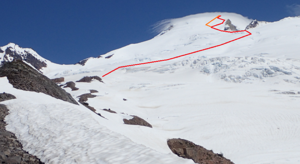
The red indicates our route up the Easton glacier and the orange indicates our way down. We took the red to stay close to the ridge to try and mitigate avalanche danger.

The red indicates the way up and the orange indicates the way down. A closer view of the headwall.

A look at the route up Sherman from the headwall. This is a more complete view of the route. Climbed a month prior.
