
Big Craggy (8,470ft) and West Craggy (8,366ft)
August 5-6, 2010
Linsey Warren
Kyle Finnegan
-- Day 1 --

1.15pm – Leave Copper Glance Lake TH
7pm – Summit of Big Craggy
8.15pm – Camp on the Craggy Col
-- Day 2 --
6.30am – Rise and shine!
7.00am – Leave Col Camp
7.54am – Summit West Craggy
10.40am - Base of Craggy Col
1.15pm – Arrive Copper Glance Lake TH
We left the trailhead around 1.15pm after we finally found it! It took us a while since we thought we were on the Eightmile Road and were following it for a ways when it turned out we’d missed the turn off and were on Thirty-Mile Road. A good way to know if you’re on the right road is to take the left hand turn marked only as road 1530. It almost immediately turns to a gravel road – and that’s the one you want! We accidently stayed on Thirty-Mile which is paved the whole way. We actually ran into a County work force. Kyle and I laughed and felt like we’d stumbled across a scene from ‘O Brother Where Art Thou?’ when we saw the stripped uniforms laboring on the side of the road.
We got going and the trail was solid. Easy going. The book says to veer right after the trail crosses Copper Creek and so we literally did and bushed whacked to the base of Big Craggy. The bush whack wouldn’t have been so bad had it not been for the mosquitoes. We passed a small pond (not marked on the map) before going up and to the scree. We hit scree around 4pm and realized we’d need more water soon and the only visible water was a small lake below us (immediately SE of Big Craggy – but not marked on the map). Although it appeared most mountains in the area still had snow on the N sides and so we hoped we’d find some run off and if not carry over to the ridge between Craggies and make camp and decide what to do. Luckily we came across a patch of snow – not so fortunately there was no stream to pump and Kyle was really needing water – so I pulled the stove out and we melted enough to drink and mixed it with 50% snow. I had forgot a bottle so I was trying to be extra cautious and conserve. When we reached the “summit ridge” on the E side there were more patches of snow but still no real run off that could be filtered. Quick summit shots and a pika later we went to descend the WSW tending ridge. But in spots it was difficult to follow and wasn’t really helpful on the descent – just on the traverses. So it was a good marker, but it didn’t make the descent a ton easier and the route was quite clear. There wasn’t any snow in the middle of the ridge (approximately 7550ft) – a few spots on the N side a little lower. But we decided to make camp since we’d felt a few sprinkles and there was thunder and occasional lightening to the S. Made camp in a really nice spot between a tree and a rock (so pretty sheltered) and pretty flat. Kyle has no idea how lucky we got!! Could hear things moving all night. Finally I woke Kyle up and he said he hadn’t heard anything – he looked outside the tent and said he didn’t see anything but later checked again and saw a goat wandering around. Lots of tracks in the area lead me to believe they’d been poking around. The lightning flashes lasted all night.

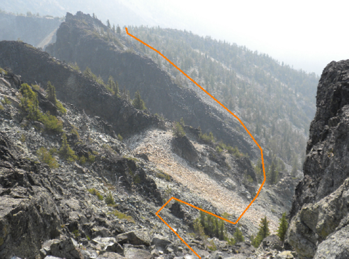
Looking down from the West Craggy’s high ridge –the ridge between Craggies.
We got up around 6.30am and had a snack before we left around 7am. I had our food and water to consolidate gear – and I had the smaller pack. We traversed the ridge on the S side below the ‘top’. At one point we climbed to the top of the ridge for a better vantage point and realized we’d made more work for ourselves because there is a ‘cleft’ in the ridge – which drops about 30/40 feet and must be descended to go around. After that it is relatively straight forward – traversing W and up aiming for a notch in the high ridge. After having gained that notch it is a really quick jaunt to the summit traversing the W side of West Craggy which is a relative gentle, albeit expansive, scree slope. We reached the summit around 7.54am. I was a little concerned about how hazy the air had been all day. It looked like smoke to the S and NW. The descent went well – although Kyle knocked a big rock down! We packed up camp quick and descended immediately off the ridge.
Lower down the SE route.
Saw goat tracks, but not human, so I’m guessing we took a little less of a standard route. We came down between the two small lakes (again not on the map but located at the top of Copper Creek and about 200/400 vertical feet down). We pumped water and tried to take a quick break (mercifully free of mosquitoes but the ants, ticks and bees were enough motivation to move. And in order to avoid all the bushwhacking we stayed closer to the base of a ridge. Eventually, I knew we’d have to do a little and we delved in. Kyle first because I scream when I get the big full body webs on me. And of course the mosquitoes came back full force once we entered the moister tree region. So Kyle got to hear my constant – move faster!! I don’t want to get bit! We came out right by the lower ‘pond’ marked on the Copper Lake Trail. Flushed with success and over the mosquitoes we made good time on the trail. Back to the cars around 1.30pm.
Conditions/ Objective hazards –
Rock fall and loose rocks. Overall minimal exposure though.
Trail Conditions –
When used, good and clear. Off trail, cross country was primarily scree.
Bugs -
Yes. Mosquitoes around the creek and bushwhack, but other than that not too bad.
Water –
Above the lakes it is only available in small patches of snow (didn’t see anything ‘pumpable’.)
Animals -
Not many! A goat, a pika and a few chipmunks.