


St. Sunday Crag via Pinnacle Ridge (August 26, 2017)


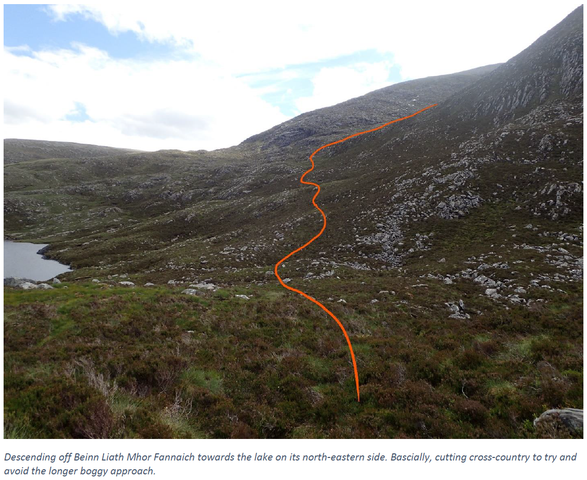
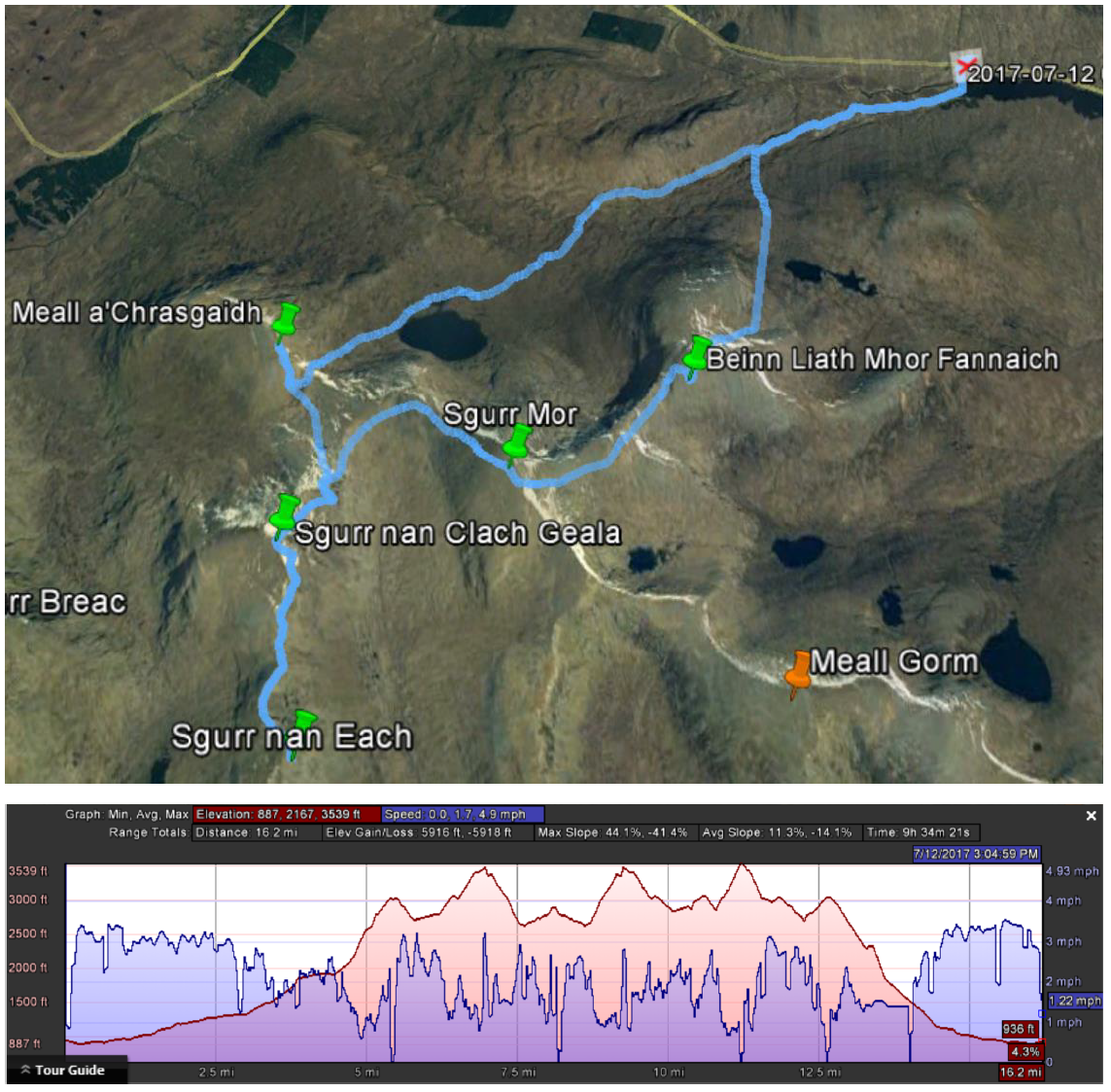
Meall a'Chrasgaidh, Sgurr nan Clach Geala, Sgurr nan Each, Sgurr Mor, Beinn Liath Mhor Fannaich (July 12, 2017)


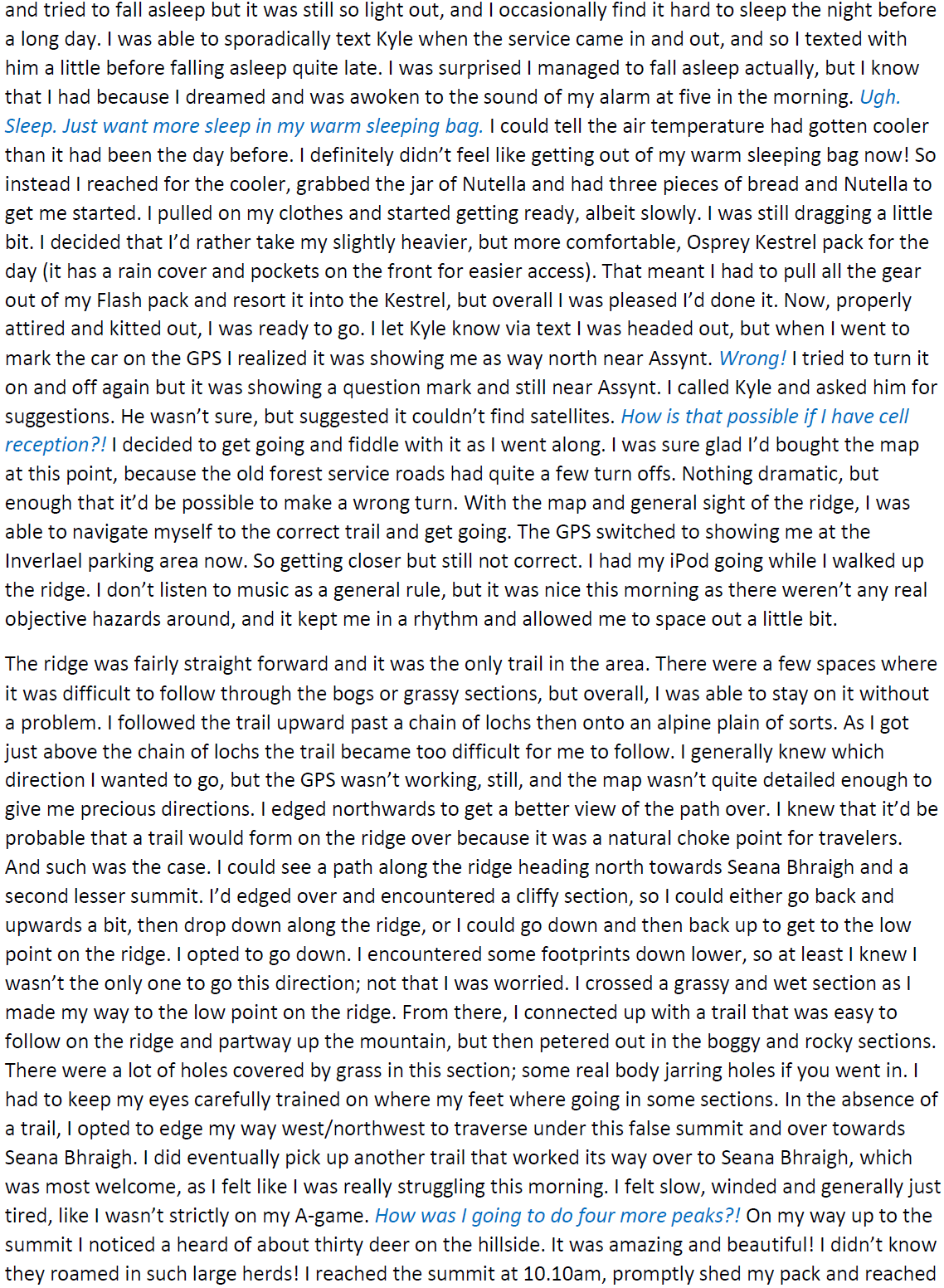
Seana Bhraigh, Eididh nan Clach Geala, Meall nan Ceapraichean, Cona'Mheall, Beinn Dearg (July 10, 2017)


Ben Kilbreck (July 7, 2017)


Ben Hope (July 7, 2017)


Ben Nevis via Tower Ridge (May 6, 2017)


The Great Pasayten Peak Grab (July 12-16, 2016)
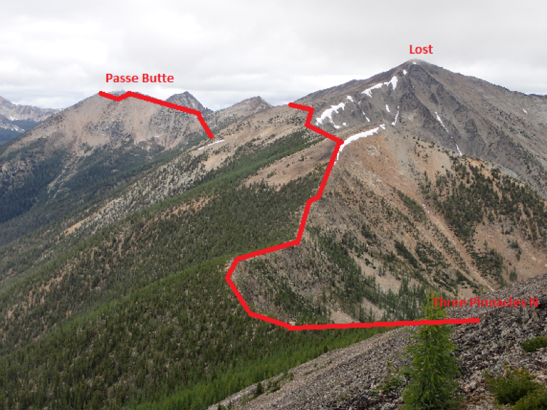
Three Pinnacles S (8,123ft), Three Pinnacles N (8,124ft), Passe Butte (8,140ft), Many Trails (8,241ft)
Dot (8,220ft), Ptarmigan (8,614ft), Sheep (8,274ft)

July 12-16, 2016
Linsey Warren
Laurel T.
I was originally thinking of taking seven to nine days in the Pasayten. In my mind it’d be an epic peak grab in wonderful sunny conditions. But Kyle’s work decided they couldn’t be a man down and he couldn’t get the time off. I went back and forth on whether to go, whether to go solo, or whether to invite a friend. In the end I phoned a friend, or a new acquaintance in this case. Laurel said she was game for a multi-day peak grab. I asked her if she was game for a tough trip, long days, unflat camping surfaces, scree and bushwhacking. She said she was. Luckily she was very trusting and I just said to bring a pack, a harness and a sense of adventure and we were going to see how many peaks we could hit. And she agreed. That is how this trip got started.

Day 1 – Approach to ridge below Three Pinnacles
Rise and Shine – 5.00am
Depart Kirkland P&R – 6.10am
Arrive Billy Goat TH – 10.50am
Eightmile Pass – 12.30pm
Lost River Crossing – 3.50pm
Ridge Camp – 8.00pm
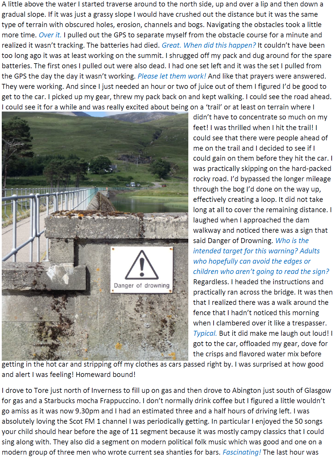
We met at the South Kirkland Park and Ride at 6am. Early but on a work Tuesday I suppose it wasn’t too far out of the norm. Kyle drove me to the Park and Ride where we met Laurel in her van waiting on the west side of the parking structure. Nice for her living in her van she just slept there. I gave Kyle a hug and a kiss and got in the van with Laurel. It felt nice to be going on a trip with another girl my age.
It was funny as we were driving over the pass on Highway 20 Laurel’s car couldn’t get up past 50mph or so and we saw a sign that said something to the effect of ‘Backups of 5 cars are illegal’ and Laurel went ‘Oph! Guess my car can be illegal!’ It took us quite a while to get out to the trailhead but we did make it! And this time I was a much better navigator than when I tried navigating with Kyle many years ago. It was funny, when we got to the end of the road, Billy Goat Trailhead, there was almost no room to park. We were really surprised that on a Tuesday this far off trailhead would have so many cars, but we were able to find a parking spot at the very end near a picnic bench. We pulled out our gear and started redistributing it. And while we did that Laurel dug around in her van looking for a pair of gloves for me since I’d forgotten mine. Good thing she lives out of her van because she was able to scrounge up a spare pair. It didn’t take long for the mosquitos to find us though and once that happened packing sped up.
As we were packing my sunscreen dongle exploded so we left it under the wheel. But we’d only got fifteen yards from the car when Laurel realized she’d forgotten something so she went back and put the sunscreen away and grabbed what she needed. False start but we were on our way now!
The trail (Trail #477) was in really good condition up to Eightmile Pass and over. It was just over four miles from the trailhead to the turnoff. The ‘turn off’ is unmarked and unmaintained. Essentially, follow trail 477 to Drake Creek. Where the trail intersects the river there is a campground and then a bridge to cross over the river. The GPS said that the unmaintained trail would start on the far side of the river but the map said it would start on the side we were on. I asked Laurel if she’d scout around the camp site area while I checked the maps. Fortunately for us she found what looked like a trail. Honestly, I was impressed she found this barely visible thread. I might have assumed it was a trail to go to the bathroom or something but it turned out to be trail 459 which was what we were looking for. It was not in good condition and we ended up crawling over and under lots of lots, and bushwhacking through several sections. What I’d estimate was a mile took us about an hour and a half. It was Laurel’s first taste at unmaintained trail, but it certainly would not be her last on this trip.
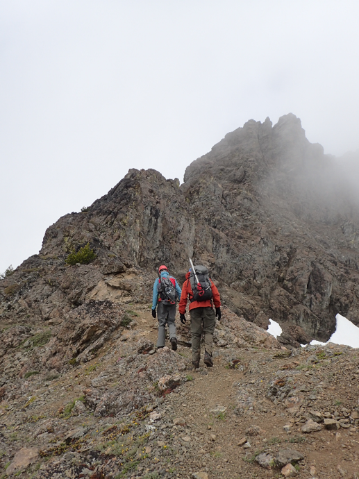
It started drizzling a little we were walking but fortunately for us it didn’t get too wet this first day. And after that first mile the trail opened up a little more onto a rocky hillside so we were able to travel a little faster. We made it down to the river and were able to find a solid log to cross. Laurel went first and I ran off to find a good place to go to the bathroom. I also wanted to go in a more open place because I thought I saw a tick on me earlier and was freaking out. Now I’m not sure if it was a tick or just my paranoia about ticks this year. I had brought the rope partially for this section because on the map it looked like it could be cliffy and when we got there I could see that was the case but fortunately it looked like it was only a short section and one that we could navigate around. Essentially from the river crossing we headed straight uphill with a slight rightward (northward) leaning. It was on steep dirt with some foliage and rocks so it was fairly tough going but overall not too brushy. And before we gained the ridge there was a large talus field we could work up. We intersected a ridge at about 5100ft and followed that up to the NE Ridge on Three Pinnacles. It was treed down low and at one point I saw a deer and then it saw us and freaked out and bolted. We were probably the first people it’s seen out there. We worked ourselves up along the ridge until about *7,100ft where we stopped at a lovely flat spot and pitched the tent.
As I set up the tent, Laurel worked on getting the stove going for dinner. I did a so-so job on guying out the tent. As it turns out it was a work in progress on this trip but I felt like I started to get better as the trip went along. As I changed into my ‘tent clothes’ as I call them Laurel told me she wasn’t feeling good. Initially I thought she just meant she was tired. But then she told me she thought she was really going to throw up and walked away from the tent and started throwing up by a tree. I was both worried and feeling terrible about the situation. We’d bushwhacked out so far it wouldn’t be easy to turn around at this point. Did I push too hard? Was it a nutrition or hydration issue? Perhaps she was sick before we started? I have to say though for not feeling well she took it all like a trooper. Understandably she didn’t want to eat that night but I kept telling her to eat. I tended to think it was a nutritional and hydration issue because when I work really hard in the mountains I can feel that way.
And that concluded our night. We had made it to the edge of the zone I was aiming for so that was nice. But as I thought about Laurel not feeling well and what the weather would be like and started weighing factors in my brain I found it hard to fully turn off and sleep.
Day 2 – Three Pinnacles, Passe Butte, Many Trails
Rise and Shine – 5.00am
Depart Camp – 6.15am
Three Pinnacles S – 8.15am
Three Pinnacles M – 9.00am
Passe Butte – 2.30pm
Many Trails – 7.00pm
Camp – 12.00am
And so it was. The morning came way too early. It’s always sad when you can tell that the light in the tent is growing stronger and it’s not just moonlight anymore. There’s no stopping the dawn and once you know it’s starting and the alarm will be going off soon it’s hard to go back to sleep. The alarm went off at 5.00am. We didn’t immediately get up, it was more of a slow rise and shine. We packed up and got going by around 6.15am. Laurel said she was feeling better this morning so that was a good start!
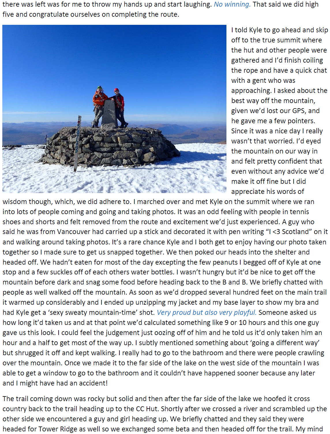
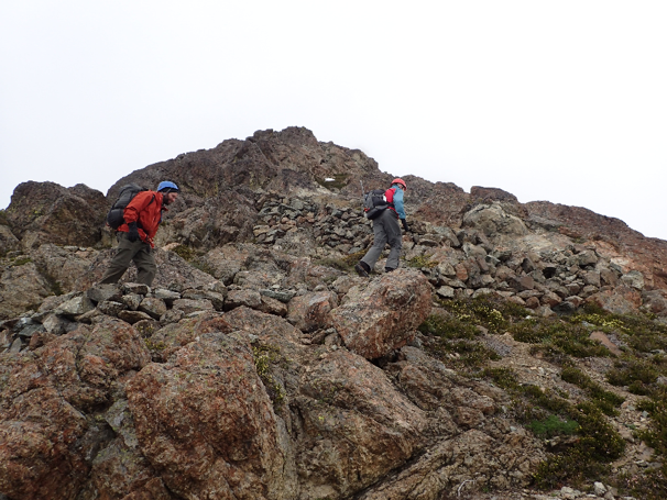
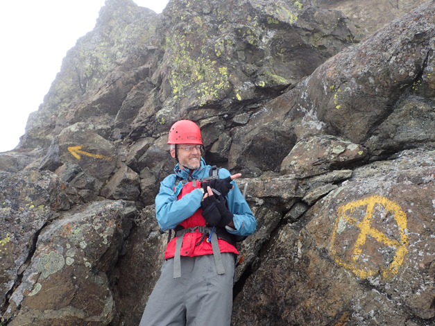
We had to work our way up and around the ridge. We stayed on the ridge or just to the south of the ridge and it was all very doable. There were a couple sections where we did a few Class 3 moves but otherwise it was fairly straight forward to gain the ridge just south of the southern summit. From here it was a little more interesting. Helmets on type of interesting. From the ridge we had to drop down a 40-60ft section of class 4 and then there was a little bit of class 3 up before it tempered out to class 2/3. Mostly walking up what we determined was ‘chunky bit scree’ we reached the summit at 8.15am. This first summit was the southern-most summit which resides at 8,123ft. I kept checking the GPS because a peak like Three Pinnacles it can be confusing to find which pinnacles are included in that three and make sure we were hitting the correct ones. Also, on the summit someone had made a lovely summit cairn that was a perfect little toilet seat. I took a seat on it and it was comfortable and with a solid hole in the center. We joked that it was the best toilet for miles. From there it was only 45 minutes for us to descend the scree and scramble up the next hump along the line which was the middle and true summit at 8,124ft. We tagged both because they were so close in elevation to each other it seemed wise. Don’t want to have to bushwhack out again! Laurel created the summit sign for us and made a great pirate map version of where the summit actually was. Couldn’t have been more accurate!
From there we were running very low on water and hadn’t had a break all morning so we headed over to the lowest northern summit and that had three possible summits. Lots of bumps on this ridge! We stopped just on the north side of the northernmost hump at a snow patch and melted snow for drinking water. It’s a slow process and feels tedious when there are daylight hours to be using but it was a good time to grab a snack. Somehow I got the last bit of water and looked down and found there were about five dead ants floating in the water. I looked over to Laurel and said ‘’Gee! Thanks Laurel! I get the ant soup!!”. Ugh! I tried to pour around those and get them out. As much as I needed water I wasn’t at the point of eating ants yet. After that we had a long section of ridge in front of us. Overall the ridge was very moderate but it did involve a lot of travel over scree and through one shrubby section when the ridge dipped low enough. In the morning we’d had some misty clouds roll in but by the time we had started our long ridge traverse the sun was out and it was perfectly pleasant. We had talked about whether or not Laurel wanted to try Lost Peak as well but she said she was fine traversing under it which was probably just as well because it would have added a good 600ft of gain or so and I wasn’t so tempted to go back. Instead we ended up traversing the western scree slope. This was the real deal scree slope. At one point I took a step and moved a rock and the whole slope of medium sized rocks above it started to slide. It wasn’t dire, I could move and it wasn’t going to sweep me away. But it just goes to speak to the stability of some sections in general. The traverse seemed to go on for ages and we still had a while to go and I could see if we traversed over to the ridge again we’d have to do a lot more up and down, so instead we dropped another couple hundred feet to gain a treed bench and followed that roughly north to a col between Pass Butte and Point ***. This was all Class 2/3. For the most part we just hopped over rocks etc. I kept nervously checking the GPS and map to make sure we were headed to the right bump on the ridge because several of them looked to be of the same height to me. Every so often Laurel would go first and if she asked where to go I’d just general point to Pass Butte and say“All roads lead to Rome”. It was kind of my way of saying there is no wrong way as long as you head in that general direction. It was interesting for me on several occasions to follow because often times I wouldn’t have chosen that way and it was hard to not comment on that. I’m sure it was annoying to Laurel at some point in the day. But we made the col and it wasn’t long from there up to get to Passe Butte. And of course, per what is now becoming too common, there were two summits that looked of general equal height. We went up and over one to get to the other but didn’t take our picture until we reached the far (WNW) point. They are very close. It only took us about ten minutes or so to scramble between to the two points.
It was on this point that I had an ‘Oh shit!’ moment. And it was a big one. My eyes travelled from the dark pyramid shaped peak in front of us and then along the ridge to a peak well off in the distance that I knew without checking the map was the actual Many Trails peak. “Ohhh shit!”. I felt bad even telling Laurel that was the case. It was disheartening to me to see that there were a lot of obstacles in our way between here and there. But sometimes, that disheartening moment also seems like a direct challenge to my willpower. I had it in my brain that we’d do Many Trails today and that’d free us up to move across the valley the next day. And it was only 2.30pm so it’d be hard to stop where we were and wait out the rest of the day. So we dropped to a spot between Pass Butte and Point ***** and dropped our packs. I pulled out my little Flash Pack and Laurel was able to turn her pack lid into a waist pack and tie the rope around her back. Away we went. It took us a little time to get through the thick shrubbery on the ridge and after that it was anyone’s guess. We opted to go right (east) around the point. In reality it present a lot of ribs and scrambling that could have been avoided if we had just dropped off of the ridge straight down to the lakes below on the east side. Instead we slowly made our way around the point only to run into a ridge that was cliffy and forced us to descend further. Eventually, after being forced to descend what I’d estimate as several hundred feet we were able to traverse over to a low spot on the ridge, regain it, and travel along it. Along this path we came across several fresh looking goat tracks and I had this panicked moment where I wondered if we should have tied our packs to a tree in case curious goats came poking about. I was remembering a tale from Chris and Radka where a goat literally ran off with one of their packs. And then my mind started thinking about what would happen if a goat ran away with one of our packs. I didn’t think we’d die. It’d be more an annoyance and loss of gear/money. But it would also effectively end the trip and mean an uncomfortable night or two.
At about 5.30pm Laurel said she thought she was done for the day but once we had gotten this far I wanted to continue. But I was torn. I didn’t want to do a party separation, especially right before the Class4/5 unknown section. But, the determined side of me won out and I left her with the stove (we’d brought to melt water) and told her to melt water and fill herself up and then melt another liter and leave it in the pot for me. We hadn’t had a lot of water that day and I was starting to feel the fringes of dehydration affecting me. I then took the rope, the rack, the GPS, the map and the PLB and headed off along the ridge. It was fortunate that from her nice gentle dip in the ridge she could sit near a tree or in the open sun and she could see the majority of the ridge that I was going to travel. And hopefully my red helmet, red jacket and pink top would stand out on the rocky landscape.
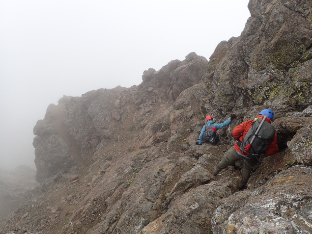
I started off and immediately hit the section that looked the hardest from a distance. At first I thought about giving up. I didn’t want to do a tricky section solo in case something happened. I then thought about going down and trying to get around. As I started to descend I had this moment where my brain asked “What are you doing?!” and so I went back up to the ridge and found what has to be the best way. It was a bit steep and somewhat exposed (but not terribly) Class 4 section. I managed to use a lot of little shrubs to veg belay myself up to the ridge and continued to use the little shrubs and trees to work along the ridge. I predominately stayed on the right (east) side of the ridge for this initial ‘technical’ section and in several sections scrambled just below the ridge. After this short section of ridge it opens up to be just a walk over talus. There are lots of faint trails from what I can only presume is mountain goat activity. Pang! Again, hoping no goats were eating our stuff but I knew there was no changing it at this point. I didn’t want to stop because I’d told Laurel my plan was to try and summit by 7pm and be back to her by about 8pm or so. I did make a couple quick stops to grab snow off the ridge and fill my Nalgene in the hopes that the sun would help melt the snow a little and provide a little extra water. Also, after I was certain I’d left the ‘technical’ section or at least the part where I felt a rope might be needed I dropped that and the rack and continued along up to the summit. I reached the summit a few minutes before 7pm, snapped a couple selfies and looked down the north ridge. If truth be told, the north ridge might be just as good of a route and then you wouldn’t have to go around the large point on the ridge. But! No time to contemplate that at the present. I was getting tired and still had some serious terrain to cover before a rest was possible. I scooted off quickly and tried to eat a few snacks as I walked. When I reached the point I’d dropped the rope and rack I decided to put my harness on and be ready to rappel if needed on that fourth class section. As it turns out I was able to make good time back tracking and I was off the Class 4 section before I realized! I think going down actually went better than going up!
I tried yelling and waving to Laurel as I got closer but as it turns out she didn’t see me until I was practically right back at that same spot. I quickly took the water she’d saved for me in the liter pot. It looked chunky. And I told her I just needed to sit down a minute. It was at this point that I was really feeling the hunger and dehydration. I generally felt strong but a combination of those too things were making me feel sick. I only sat for ten minutes and then we had to get going. It was 8pm and we only had a little over an hour before we lost the daylight and I was not planning on retracing our steps back. We were moving slowly on the way over and I didn’t think it’d be any better on the way back. And I really didn’t want to try to route find a brand new route in the dark. So we got to the point where we had gained the ridge and then dropped closer down to the lakes and wrapped around the base of Point ****. It was here I was kicking myself for not bringing our gear down with us and camping at the lake. We could have had fresh, pumpable water and we could have been done. I was really feeling my miscalculations and mistakes keenly at this point. But what made it worse was I felt bad for Laurel. We were moving but still not fast enough to make it around the corner base of Point *** and get eyes on the best route before dark. We were going to have to literally feel our way up this section in the dark. Crap. I was tired and felt bad. Laurel asked a couple questions about which way to go and I was a little too brutally honest, born from how tired I was feeling, and said something to the effect of “I really don’t know Laurel. We’re just going to have to try until we find a way.”. Just saying it aloud was heart breaking. Fortunately, we worked our way around the base until we found a way that looked like it’d go uphill. We scrambled up a short Class 3 section, being sure to stay very close to each other so as not to knock rocks down and to stay within sight. The first 200ft of vertical was fairly scrambly but after that the grade mellowed out a little bit and it seemed like we’d be able to follow this moderate grade all the way to the ridge. I could just see the faint outline of a ridge above us in the twilight. Every so often I’d turn my headlamp on to full power and try to scan as far uphill as I could to pick our route. We intersected the ridge and followed it back through the trees and shrubs to where we had left our packs. I had my fingers crossed we’d find packs when we got there. Praise the lord we did! But alas, we couldn’t camp where they were. We were extremely low on water and I was already feeling dehydrated. If we didn’t move now we’d have to do it in the morning. I had scoped out a few snow patches several hundred feet below before we’d left for Many Trails and we had agreed that we’d aim for those. By this time it was 11pm and we were dragging. If not from the mental exertion our feet and bodies in general were just calling for at least a short break. We found a snow patch but we were having trouble finding a flat enough spot to pitch a tent. We went down another hundred feet from where we found the first snow patch and called it. It was the flattest spot we could find (not really flats at all) but it had a snow patch. So Laurel wiped out the stove quickly and started melting snow and boiling water for food and I grabbed a rock and started to try and carve out a spot big enough for us to put the tent down without rolling off. I found myself wondering how I’d found myself digging into the side of the mountain after a long day trying to make a space to sleep. I was tired before, but digging around like a caveman certainly seemed to take the rest of my energy. It wasn’t glamorous but after about twenty or thirty minutes I had a space big enough to get most of the tent footprint down. I pitched it as well as I could, not that it’d matter at this point, and we threw our stuff in, grabbed our food and I think Laurel was out before she could eat much again.
I had a harder time going down as my brain was working through the numbers and the plans for the next day. Eventually I did start to fall asleep though.
Day 3 – Dot, Ptarmigan
Rise and Shine – 8.00am
Depart Camp – 9.30am
Dot Lake – 2.10pm
Dot – 4.00pm
Ptarmigan – 6.00pm
Camp – 8.00pm
I woke to that same morning glow, the sign that the day was starting despite my will. And if the daylight evidence wasn’t enough the loud crowing of the birds surely did the trick. There was one particularly noisy crow that seemed to be sporting with us. We got up at 8.00am and moved slower this morning. But I had told Laurel this would be an easier day today. Well, “easier”, it was still going to be a two peak kind of day. I was surprised that for the second night in a row I didn’t eat anything during the night. Quite frequently during these long day trips I find I get hungry in the night and can’t sleep but that didn’t happen at all during the night. And when I woke up in the morning and looked at my gluten free poptart, lacking any of that decadent frosting, I just wasn’t motivated to eat it. I knew I’d want the energy later but there was so much floating in my water at this point and the poptart was so dry that I only managed to get about half of it down to start.
As we started to pack up our gear I took the fly off the tent and hung it in a tree in the sun to help it get twenty minutes or so to dry. It helped a little and at least was a little drier than the night before but it was still somewhat damp when I rolled it all up and stuffed it into my pack. Of course as we descended we started looking at where we were and about two hundred feet below where we were we passed a beautiful flat, grassy spot. I knew it was bound to happen but still a bit tragic when you think of how dreamy it would have been to have camped there. But honestly, I don’t think we had it in us to get that much lower.
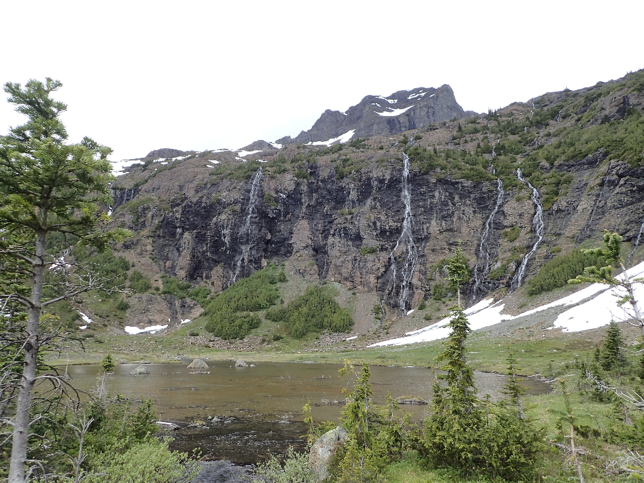
We wrapped around the hillside traversing down and over to *Shellrock Pass. We didn’t quite go to Shellrock Pass but we passed about twenty feet below it and made a descending traverse across the basin on the NE side of Lago Mountain. I originally had thought we’d stay higher to avoid the brush but Laurel wanted to try to drop down and go slightly through the treed section. It was really one half dozen or the other so we decided to drop. Laurel took point, spider guard, and led us off. Just about as soon as we hit tree line we also hit mosquito line. They weren’t terrible but they were annoying and biting. But we also found our first running stream in nearly two days!! It was glorious. We stopped and pumped water immediately. I was drinking as I pumped! I wanted to get as much water in me as possible and then I’d carry two full liters. I had brought enough NUUN tablets so that I could have two tabs a day. I quickly threw in my tablets and started trying to rehydrate myself. Its amazing how a little water can really perk up the day. And as we were bashing about in the shrubbery Laurel stumbled across a balloon that said “The Party is Here”. Surely it was a sign! But also weird, I tend to find lots of balloons in the backcountry and in this part of the state in particular. We found two more balloons on this trip.
We were aiming for a treed gully that broke up a ridge separating a basin on the north side of the one we were currently in. I just scoped it from a distance and it looked like it’d go so we went over to explore. And, it did in fact go. I told Laurel we’d stop at the top of that gully and so we did. But as soon as we stopped it seemed that the mosquitos found us and we suddenly didn’t feel like sitting much anymore. This slightly higher basin/cirque to the north of the one we had just scrambled out of looked a lot bigger. Laurel asked me what our general line was and I told her I was planning on staying fairly high on this one. I didn’t want to lose too much elevation by dropping down into the trees (looked like we could easily lose 1000-1500ft if we dropped straight down and over). I got the distinct impression she wasn’t impressed or greatly enthused by the plan but luckily she was willing to do it! And we actually ended up finding a really sweet spot that hugged the sree/open section above and the treed section below. I call it the ‘sweet spot’ because it’s not rocky so foot steps are easier to place for the most part, you can generally see the route and it’s not low enough that you’re truly bushwhacking. It was along this stretch that I kept finding threads of game trails and I realized it feels good to know that the line I was traveling was intuitive even for the animals. IT made me feel even more in tune, or part of the natural world around me. That my mind would think along the same lines as every other living creature in the backcountry. Laurel even commented that this section went faster than she thought it would. We hit Dot Lake at about *****pm and only briefly stopped for a bathroom break and to filter more water. I knew there was a tarn between Dot and Ptarmigan but you never know when something will dry up. Don’t take water for granted or as I said that day “Don’t look a gift horse in the mouth!”. It was such a beautiful spot that I almost wanted to stop and camp and swim in the water. If we had had more time in the day I might very well have considered it. But alas, we started uphill, aiming immediately north of the lowest Dot Lake and scrambled up a lightly treed dirt and rocky section to gain the Eastern arm of Dot Mountain. It was very easy to gain the ridge here (Class 2). Once again at the top of ridge we took a quick break, and once again the mosquitos found us rather quickly. But this time we took more time as I tried to figure out why the GPS was sometimes showing tracks and sometimes not showing tracks. My best guess at the time was that it was running out of memory but I wasn’t entirely sure what to do about it so just crossed my fingers that we’d be able to pull the data afterward.
We followed this ridge west all the way to the base of Dot Mountain all the while having a really good discussion on religion, spirituality and reincarnation. It was getting deep, deep in the backcountry. We dropped our packs with the exception of my little daypack which Laurel hauled up Dot. We summited ‘Old Lady Dot’ at 4.00pm and stopped to take in the views. I was grateful that Dot Mtn was the peak closest to Ptarmigan because for a moment I started to second guess myself on the way over and thought it might be the next peak south on the ridge. The GPS was telling us Dot was next to Ptarmigan which matched my fuzzy memory of the last time I was there but I hadn’t brought the map for this part of the trip. I was really just making it up as I went along. It would have taken more time to scramble over to that peak to the south though. I remembered there being a Class 3/ 4 section on the ridge. Once again we descended, grabbed our packs and walked over to the tarn between Dot and Ptarmigan. Once again, a lovely spot to camp but not the place for us. We pumped water again, as I had a suspicion we might not see any more for the rest of the day. In fact, I filled up my space liter Platypus bag I had brought so we could use it for dinner that evening. It was around here that my ankle started really feeling it. I had a suspicion it was the sudden and hard use of it and all of the side hilling without a lot of quality stretching in the evening. I had meant to stretch the night before but ended up just rolling around pretending to stretch while I was in my sleeping bag. I threw back three ibuprofen (which anyone who knows me knows that’s a lot as I tend to only take two). And away we went. Up Ptarmigan.
The wind started to pick up while we hiked up Ptarmigan. I was going fairly slowly; a combination of long days and trying to find flat and rhythmic steps for my feet. The wind picked up as we went higher. I thought I remembered there being a register on top of Ptarmigan which I told Laurel but when we got up there we couldn’t find it. So far we were batting nil on the registers. Some creative cairns but no registers. We didn’t stay long on this summit. Just enough time to write a summit sign, snap some photos and get scooting. Laurel handled all of our summit selfies and did a stellar job. She always seemed to get us in the photo. And by this point we were getting a little better about getting positioned quicker as opposed to the first peak trying to figure out whose side we should be on and the uphill vs downhill. I couldn’t believe I was back on Ptarmigan but it is a lovely peak. We generally followed the ridge north and downhill. It was overall fairly moderate. There were a couple spots where it looked steep from a distance but when you got there or around to a better vantage point you could see it was fairly moderate just scree and talus. At one point we startled a poor marmot and it took off running at a good clip and just kept running downhill. I was wondering at one point it’d be a safe distance from us! Half a mountain away? It stayed fairly breezy as we traversed and traversed north. I could tell we were slowing and the GPS was telling me the trail was still one hill away when all of the sudden we were standing on a trail! Hooray! I was skeptical though. It looked like a real trail but at the same time it might have just been a really worn game trail through the grassy alpine. We followed it to a spot where there was a post being supported by rocks. I didn’t see a sign on it but Laurel later told me see saw a trail number on it.
From here we gained the ‘pass’ and we dropped our packs to scope out a spot to camp. I was keen to get over the pass and find a place that was a little more sheltered from the wind if at all possible. So I hiked off around the corner to go and see if the trail dipped and there were flatter spots down a little lower. About five minutes down the trail I ascertained that it generally looked positive and went back to grab Laurel. After all, just about anything was going to be better than the night before! I staked and guyed the tent out, it was getting better and better! And Laurel started the water for dinner. We could see clouds building in the distance to the East as we got ready for bed and as a general rule I like to try and keep my stuff at least close to the tent so that if it does rain I can easily grab it and pull it in. So in this case I had all of my stuff under the fly and we put our food in Laurel’s black industrial trash bag and wedged it into a little tree about 3 feet off the ground because we’d seen evidence of rodents in the area. Laurel went down for the count right away and again I was having trouble getting right to sleep. But I did employ a new trick I discovered that I’m keen on and wrapped my now nasty and dirty buff around my blow up pillow so that my sunscreen and bug spray covered face wouldn’t stain the fabric on that and it made it like some retro throw pillow in the tent! Win! Sometime in the night I woke up to the pitter-patter of rain on the fly. I listened a little longer and confirmed that it was in fact rain and rolled over to tell Laurel to grab her pack from outside and pull it in under the fly. I got an ‘Unh. Yah. Oh okay’ before she was asleep again! So I unzipped the tent and the fly and pulled her pack in under the fly and went back to bed. It was a mess of stuff in the vestibule but the important part was it stay dry. At least neither of us ever got up in the night to go to the bathroom so we didn’t have to worry about crawling over all of it. Then I just hoped that the food would remain dry and the weather would clear up.
Day 4 – Sheep
Rise and Shine – 6.00am
Depart Camp – 7.30am
Hidden Lake – 9.40am
Turn off – 11.10am
Point 6912 – 4.20am
Depart Camp – 7.00am
Sheep – 8.00pm
Camp – 9.10pm
When the alarm went off this morning my first thought was ‘What’s the weather like?’. But at the same time I didn’t want to open the mesh and unzip the wet fly. But alas. I did. And it was still raining lightly and misty. I couldn’t see more than fifty yards or so. So we zipped the tent back up and stayed laying down for another fifteen or twenty minutes waiting to see what the weather was going to do. After that time I can’t say that it cleared up much but we didn’t really have much time to wait around. It’d either clear up while we were walking or it wouldn’t but either way we still had places to go.
Packing up at least it wasn’t raining but everything was wet. And packing the wet tent up was ‘delicious’ as I kept saying this trip. Slimy, wet and cold. As I rolled it I tried to wipe off some of the dirt so it wouldn’t be really muddy but it was making my hands freeze! And I packaged it up and put the wet tent in my backpack and given how the weather was behaving both Laurel and I tried to put everything in our pack inside plastic bags to try and make sure our stuff stayed dry. As we were finishing up the last of the packing and I wandered off to go to the bathroom a deer wandered close to our camp. It didn’t seem too scared, perhaps a little nervous, but it wandered around fairly close to us. After we took off, grateful to be on the trail, we stumbled across more deer! There was something mysterious and magical walking in the misty morning air and having deer wandering around. We saw a male and two females up higher. Early on, almost immediately after we got on the trail that morning, I noticed there were footprints. Which was a little odd and almost disconcerting because I thought I had heard noises in the night and early morning hours and I chocked it up to the deer but by the looks of the tracks at least one person came along that morning. It was a bit odd after not having seen anyone for two and a half days and to see footprints way out. We never did find the person associated with the footprints but they did seem quite fresh. Honestly, not sure where they were going out there. It almost seemed creepy though.
Since we were walking on the trail, which was recessed into the ground anywhere from half a foot to two feet, the brush on either side kept rubbing up against my pants and getting them wet. Ugh. Id brought Kyle’s new ultralight half gaiters but the brush was higher than that for most of the descent down into the valley. So I got wet. There were also quite a lot of down trees on this ‘maintained’ trail. In hindsight it should have been our first clue, our first warning. I was expecting that when we reached the valley and the Hidden Lakes trail (#) there would be a very wide well established trail. But, lo and behold, it was just the same looking if not worse than the one we had gotten off of. Clue number two. Now, we had talked about evaluating the weather and how we felt and making a decision on whether to turn around at this junction or to press on towards Sheep Mountain. I was quite keen on Sheep but I didn’t want to push too hard. I felt like we didn’t stop and have a discussion we just turned northward and continued on towards Sheep. That very well may have been my fault for forgetting to have a real discussion. We briefly talked about it but the weather wasn’t too bad so far and we were hopeful that the trails today would be much better so we’d move faster.
That idea was shut down fast. The trail was not in good condition at all. It was still visible enough to follow but there were lots of down trees and sections where the trail had broken out and as a result it really slowed us down. Again I found myself being hopeful that once we got to the next trail itd be better. As we walked along the northern Hidden Lake I heard a sound. It sounded like huffing. I started looking around and saw a mammal in the lake water. It was either a beaver or an otter. We later came to determine we think it was a beaver. At the headwater of the lake where the river entered it there seemed to be a buildup of logs and sticks. This section of the trail seemed to go on for ages. We stopped just before the trail crossed the river at a lovely campsite. There was some old, presumably, mine equipment here. But there was a log we could sit on and have some snacks so we took a moment. It was here we took a picture of my pants which were down around my hips. They kept sliding down the whole trip and by this day they were really sliding down and it was making it hard to walk. Laurel took a picture to commemorate my gangsta look. When the mosquitos came we decided to call the break and get going again. We had to cross this river which wasn’t too big but required us to do this awkward shimmy across a log and some gymnastic moves at the end of it. All of the moves up and over the trees was really taking a toll. We followed the dwindling trail to just past the river and another campsite to a fork in the trail. There was a stone arrow pointing down the trail (the way we had come). We turned right onto Trail #451 and promptly came across some orange tape that looked like it was once across the trail and an old Forest Service sign that was dated 2014 and said the trail was closed. We figured it was for a fire or something and that the danger was past. Well. We were partially correct. There wasn’t any ‘danger’ per se. But lots of widow-makers. We crossed uncountable downed trees. It was tedious, frustrating and very physical work. At first the trail was at least able to be followed but after only a half a mile or so it became very difficult going. Hundreds of downed trees. We would occasionally get a ten or twenty yard section of no downed trees and want to celebrate but quickly have that dashed as we came across more downed trees. We were tiring and going slower and slower through the downed section because we were having to crawl under and climb over. Laurels long legs were doing a little better than mine. I was having to through my leg over the higher ones and pull with my thigh muscles to get over them. In the midst of this messy trail we came across a water crossing we couldn’t quite do without getting our boots wet. Laurel’s boots were already leaking water from the toe so she considered just wading it but I wanted to stop and just walk across barefoot.
Not long after the water crossing we lost the trail entirely. Crap. The GPS was of little help because it was trying to tell me the trail was on the other side of the river. That would be a negative. And the map wasn’t detailed enough to help me find the non-existent trail in a sea of down trees. We came across an area with some old tin cans and it looked like it may have been a camp site at one point a long time ago. But we couldn’t find the trail. Poor Laurel was going first to break for spiders most of the day but wasn’t used to this type of bushwhacking so I felt like I did a lot of back seat navigating which, undoubtedly is no fun for anyone! After what felt like hours and making minimal progress and knowing we still had way more miles to do I started to rack my brain for a way out. This wasn’t going to work. The only thing I could come up with was to head straight north, up and over a small point on the map, down a couple hundred feet and then back up a couple hundred feet to gain another trail on the map. My brain was warring within itself. Almost no trail we’d experienced on this trip so far had been good. Was it worth risking a very steep up and over to gain another trail that might be just as bad? My gut said it was significantly higher and therefore should at least in theory have less brush but it was hard to know for sure. Finally, after talking it over with Laurel we agreed to just go up and over. Hoping for the best. At this point I feel we were both trying to put on a happy or at least neutral face but it was just downright frustrating. So we turned from traversing the valley eastward at about ***ft and turned northward and went straight uphill. It took us several hundred feet to get out of the down trees and into the loose soil and rocky section. It was steep going as well. And just to add a bit of insult to it the weather started to lightly mist on us. I told Laurel we’d take a break on this ridiculously steep hill once we hit this treed section in the hopes it’d provide some shelter and at least provide something for us to lean up against and rest. And when we got there I felt like she briefly stopped and was kinda like ‘yah okay Im going to just keep going!’. I don’t think actual words were exchanged but that’s the impression I got. Im over it and lets get ‘er done! So we pretty much went straight up this. The misty wet continued as we literally climbed into the cloud. And we found yet another balloon on this backcountry detour. This was a Happy Birthday balloon. It was mocking us. We made it up towards the top of Point 6921 and it was quite beautiful actually. Lovely open space with the occasional trees. We actually took a summit selfie and immediately pressed on. We used the GPS heavily here to navigate through the mist and get down the easy arm. I was so glad that we only had to lose about two hundred feet or so because we didn’t have to drop back into the brush or deadfall and then we had to go uphill another three hundred feet. It was a bit brutal here but we made it up and before I even knew what was happening we were standing on a trail. An actual trail! It wasn’t as wide as I thought it might be but it was a clear and present trail and it was above the majority of trees! Yahoo! I ran over and hugged Laurel! It seemed like the right thing to do to celebrate. We followed the trail towards Peeve Pass. At one point we almost made a wrong turn but I checked the GPS and Laurel, credit to her, said it didn’t seem right. We did have several sections of down trees but nowhere near as bad. And somewhere along this Laurel was ahead of me and said ‘There’s a person!’ to which I said ‘No way!!’ but sure enough a young guy in trail tennis shoes walked up and said he was doing the Boundary Creek Trail all the way to the Olympic Coast. He did also inform us that there was a trail crew back towards Peeve Pass. Interesting. So we might see others out and about in this mess. We didn’t stay to chat long as the weather was staying misty and wet. My gaiters were pretty much just holding water in at this point and the bungee cord on them (used to tighten them up) had ripped somewhere back in all the brush-bashing.
We stopped at a water source to pump water. It was so nice to have water and stay at least semi-hydrated. After that we pretty much continued straight on up to Peeve Pass. At the pass we looked for a place to pitch the tent. My guess is we reached the Pass just after six. We poked around a little bit and found a reasonable flat spot under a tree but it had lots of low hanging branches so Laurel and I went to work snapping off the dead little under branches so we could pitch the tent. The tree would hopefully serve to keep the tent and immediate environs dry and wind protected. I knew Laurel was tired. Heck I would have been happy to call it a night at this point. But I also knew that we’d talked about heading out the next day if the weather wasn’t improved and if that was the case and we were hoping to make it out by dinner time we’d want to leave right away in the morning both emotionally and physically from a time standpoint. I ran it by Laurel and I could tell she wasn’t keen on it but she did agree she’d rather do it tonight because she wasn’t going to be motivated in the morning. So at 7pm with our kit mostly in and around the tent we set off uphill, once again guided by the GPS in a cloud. We had about 1300ft to go and we crushed it out in an hour! Most of the way up was hiking through alpine meadow and it was lovely, despite the drizzly grey weather. My boots were officially soaking wet at this point. There was a short section of boulder hopping and scrambling that was Class 2/3 but it didn’t last long. Laurel was talking about how it wouldn’t be good when it was wet and I tended to agree as it kept on and off drizzling. It was definitely going to be wet on the way down and it was hopefully not going to be dark. We got up to the top at 8pm and found the summit cairn, took our summit selfie and I walked over to take a look to see if I could see over the side (I could not we were completely in a cloud that was slowly darkening). Very shortly after that we headed down. It was a nice two minute summit break. But it was for the best. Actually the descent went better than we’d thought over the boulder section and we managed to stay closer to our original tracks for half of it. Side note: the northeast side of Sheep Mountain is quite a bit drop. On the way up I was walking about ten feet from the edge and a gust of wind came up that moved me slightly to my right and closer to the edge. I saw it and promptly moved further away! I didn’t think I’d get blown over but just to be safe I still put a couple more feet between me and the misty unknown cliff. On the way down I was navigating mostly by remembering the route and GPS and when it came time to turn off of the ridge from Sheep and head downhill towards Peeve Pass once again I missed the mark a bit and we ended up intersecting the trail slightly farther to the northeast than the way we’d gone up. But in actuality we were going to hit the trail so I wasn’t too worried and it actually worked out very well because we didn’t have to go through a treed section at all. We made it back to camp at 9pm just as we were losing most of the light (the cloud we were still in seemed to be sucking the light out of the day quicker). And just as we got back to the tent the rain really started to come down, so we hobbled under our tree and started to get ready for bed. As we were changing and doing things about the tent a spider kept trying to crawl in and I kept making odd noises and pointing and Laurel kept moving it further back. Finally we got wise and after we’d boiled the water and made our meals zipped up the mesh to try and prevent it from happening again. I probably wouldn’t have been able to sleep knowing a spider was lurking in the tent; even if it wasn’t that big. I had earlier in the day (not long after we’d departed camp and well before Hidden Lake) stopped to rinse out my bra and underwear in the hopes that the cloudy weather that morning would dissipate and reveal a gorgeous day but that hadn’t happened so my underwear was still wet. So I was stuck between wearing the pair I’d been wearing all day or wearing a wet pair to bed to dry it out. I briefly thought about going commando but then I’d have to put on and wear the wet pair tomorrow. So I put on a wet pair. Ugh. We then proceeded to eat our dinner and I spent twenty minutes looking for everything I kept losing in particular my toilet paper and ibuprofen container. I felt like a hot mess!!
Laurel crashed but for some reason this trip I wasn’t able to sleep much. I just listened to the sound of the weather. The slight drops of precipitation that were getting through the tree to our tent. This night we did wake up in the middle of the night. Laurel was sleeping with her head towards where the feet would be. I started that way but in the night swapped spots. We were both thirsty at one point so Laurel grabbed her hydration pack when she got up to go to the bathroom or do something and we both were sipping off of that during the night. And it’s funny after we both got some water we were both able to sleep again that night. Guess we were just really thirsty.
Day 5 – Getting’ out of dodge
Rise and Shine – 6.00am
Depart Camp – 7.30am
Billy Goat TH – 4.00pm
Well. When I woke I immediately pulled the tent open and lo and behold the weather was still misty, grey cloud. I was glad we had gone up Sheep Mountain the day before because we were then just going to get up and hike out today. We were looking at somewhere between 18 and 19 miles of out depending in which sign post we read where. A solid hike out. I thought it was mostly a traverse and in reality in practically was but there were several sections where we had to go up several hundred feet at a time and I felt my body protesting. It wasn’t protesting like I couldn’t do it. Just moving slower.
I pulled off my ‘tent clothes’ and pulled on my wet, humid, sticky feeling pants and hiking clothes. Without the ability to wash and dry stuff in the sun day five clothes were feeling pretty nasty. The sleeves on my long sleeve top where dark with bushwhacking and dirt. So I decided to use my sleep bra and long sleeve wool top which worked out well because it was fairly cool and blustery for the better part of the day.
We did get lucky because it seems the trail grew had been through before us and cleared a significant portion of Trail #502. In the higher alpine sections it wasn’t bad at all because there was no downed trees but at one point about halfway along we passed a section where Laurel counted fifty plus trees in a bundle that all went down on the same section of trail and there were more ahead. So glad they were cut! Makes me appreciate trail crews even more now. We did pull out the GPS on several occasions because it was hard to tell the real trail from game trails or just ‘view point’ trails or ‘horse trails’. Poor Laurel had to question whether or not I could navigate by this point because twice in as many days Id gotten us a bit mixed up. But luckily we hadn’t gone too far before I suspected something. But the misty cloudy weather was taking away a bit of my ability to navigate based off the terrain.
I did at one point have trouble passing by Two Point Mountain. I kind of wanted to summit it as it’s on the T200 List. But I had to remind myself that I wasn’t trying to start another list. It had been a long four days prior and it was wet and there wouldn’t be any views. So we continued on by. And surprisingly I did better with it than I thought I might.
On this hike out we saw a marmot and its offspring and a ptarmigan with lots of baby ptarmigan birds that ran and nestled under its wings. It was adorable. And at one stop we saw three curious deer that were munching around us. I had to stop because my feet had been in the now wet plastic bags around my feet for nearly four hours or so and they were starting to get irritated to the point of being painful. So I stopped took off the plastic bags and dug around in my bag to find my ‘sleep socks’ and changed them out so I could have a dry pair for the rest of the day. Foot care is so important. That dry pair of mostly clean socks felt great. Gave me the pick me up I needed to go down and then back up the 1200ft or so we had to do to get to Billy Goat Pass. So far that day we’d been at Peeve Pass, two unnamed passes, Three Fools Pass and then Billy Goat Pass. As we neared Billy Goat Pass the weather started to clear a little bit. Typical. As Laurel kept saying this trip. Typical! It was okay though, the weather still looked cloudy north.
The closer we got to the cars the more my feet and knees were feeling it. On the descent from Billy Goat Pass I had to really go slow. My knee felt like the pounding was finally starting to pick up and I hadn’t taken any ibuprofen that morning. But finally we made it to the car and the chips and Gatorade therein! We made it to the trailhead at 4pm. Laurel hopped in the van to move it because a car had parked really close to us and there wasn’t anyone else around so she moved it to the middle so we could throw the doors wide open, change and arrange our gear. But as she went to move the car I smelt gasoline and saw something coming from the bottom of the car. I walked over to the stain on the ground and put my finger in it and then put it against my nose. It was definitely petrol. I asked her if that was normal and she said now. Crap. We looked under the car and thought that it might be leaking something. It wasn’t gushing forth at the moment but it seemed to when she moved the car. Now feeling more than a little worried, and getting bit by mosquitos, we changed and hopped in the van. Fingers crossed we’d make it to Winthrop. We had half a tank of gas. As we started going down the road it became clear that the gas gauge was dropping a lot faster than it should have. Crap. It seemed like when she started the car and hit the accelerate in the trailhead parking lot that it leaked more. So I asked her if she could coast more. Perhaps that’d use less gas or at least stop it from leaking as much. Laurel handled it like a boss and we were coasting quite fast down Billy Goat Creek Road. At one point a car came up behind us, and we knew that we were losing gas fast, and I told Laurel not to let them pass. She asked me what to do if it died. “Just let it die in the center of the road so they can’t pass us?” and I said “Try to pull slightly over and I’ll jump out and wave my airs and try to flag them down.” Seemed like the best plan we could do. It may have been a bit rude to not let them pass us but at one point I think we were careening so quickly down the road that they started to fall back whether or not because they thought it was an unsafe speed or we were just unsafe. But while we were still on Billy Goat Road the van hit E. Oh crap. We were only halfway and we’d gone through half a tank. We weren’t going to make it. So we continued on. At least it was a Saturday and we had made it back to where there were more campgrounds so our likelihood of getting help was better.
I turned my phone on to watch it and see when we got back into reception. And as I watched the phone Laurel kept her thumb to her mouth and looked extremely concentrated. I think we were just moving this car on sheer will. At one point we missed one of the forks in the road and took the right which I think was slightly longer we debated turning around but thought that might take too much gas to stop, turn around and gain momentum again. So we kept going. We got back into reception and I breathed a semi-sigh of relief. I did want dinner though so I was hoping we would get to town.
We made it back to the main road just outside of Winthrop and had to wait at the stop sign as there was a lot of traffic on the road. I started yelling. We did manage to get into town and to a gas station. We parked right above what turned out to be the refueling area as we were leaking fuel. We went inside and asked the woman if there was anyone who could help us and she told us no and that the sign above the gas station was just an antique fun thing and they didn’t actually offer car repairs. She then told us we had to move the van because it couldn’t stay there. We told her we weren’t sure if it’d even start and she told us we had to move it. So we said a prayer and got in the car. This woman in the gas station had told us to head straight down main street and try to find parking but it was so busy in town I told Laurel to go to the gravel lot on the west side of town. We made it and parked and then Laurel asked if she should straighten the van out more and I said if she could it might help and as she backed out the car died. There was nothing left. We tried to push it a little bit but in our flip flops and sandals and newly tired we couldn’t make it move. So that’s when I said people could get around, worst they’d do was leave a nasty note. We could work out our problems over dinner at the little Red Schoolhouse. I felt bad but at least we were out a day earlier than planned and had time to handle this. So we ordered dinner and called AAA. Thank the lord Laurel had AAA. We then had to try and find out how far we could get with 100 miles of tow. The woman from AAA wasn’t overly helpful but she did dispatch someone to help us and they were going to be there in about an hour or so. Perfect. We had time for dinner. So we had dinner, strolled around town, saw the US Marshals arresting people (someone had a knife and it looked like they were breaking up a fight), went and poked around a hat and souvenir shop and then went back to the van. Just as we got there the tow truck arrived. The gentleman who was helping us was named Liam (he was from Mazama) and he agreed to take us to Wenatchee.
We had a lovely car ride the hundred miles to Wenatchee with Liam. And some interesting conversations on politics, rescue in the area, mine remediation at Azurite Mine, and a whole host of other topics. I called Kyle and he agreed to drive out to Wenatchee that night to get me. So we met in Wenatchee and he took me home and Laurel slept in her van until she could try to find someone to do repairs the next day or the day after which was a Monday. I felt bad leaving her but it was really nice of Kyle to come and get me. We made it home at about 12.20am and we were both wrecked. I had a quick shower and then we both passed out. But it was sure nice to be home and snuggle up with him.
Passes/Permits –
Northwest forest pass (we used America the Beautiful Pass)
Trail Conditions –
Um what trails? New trail lingo. Code 451 means crappy trail or non-existent trail.
Trail #477 – Good for four miles heading West to Trail #459 turn off.
Trail #459 – Hard to find the turnoff. First mile is very brushy, down trees and generally hard to follow in some spots. The start is on the east side of the bridge, head directly south through the campground to what almost looks like a game trail.
Trail #485 – From Ptarmigan Pass down to Hidden Lake it is in generally good condition. Handful of down trees and in sections the trail is starting to give out and collapse. But overall passable. The closer you get to Hidden Lake the worse the downed trees gets.
Trail #477 – From junction just south of Big Hidden Lake it is significantly damaged. Lots of downed trees make for very slow and difficult going all the way to the junction with Trail #451.
Trail #451 – Just gone. You can follow it for about a mile or two before it gets completely lost in the deadfall but those first miles are tedious and absolutely blanketed in downed trees.
Trail #533 – Boundary Creek Trial. From directly West and below Quartz Mountain where we bushwhacked over to gain it the trail is fine. There are some downed trees but it is manageable. There are quite a few unmarked turnoffs which can be confusing but overall decent trail.
Trail #502 – From south of Sheep Mountain to Billy Goat Pass it was recently cleared and in good condition. This too had a couple sections where there were lots of break off trails, horse trails, etc that made navigating a bit challenging on more than one occasion.
Objective Hazards –
Perhaps rock fall (but fairly minimal), lack of water, trail debris!!
Gear –
Helmets is all we used. 30m 8mm cord, small rack and harness as a precaution.
Water –
Snow patches for the ridge up to Three Pinnacles all the way to Shellrock Pass. After Shellrock Pass as we traversed over to Dot Lake there was running streams. Then no water from the ridge up to Dot and until we were about halfway down the trail to Hidden Lake.
Animals –
Lots! Goat tracks, lots of deer, a marmot and marmot baby, beaver and one very colorful finch!
Bugs –
Mosquitos on and off.
Flora and Fauna –
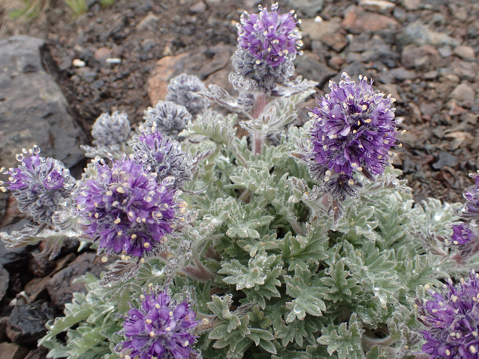
Beautiful wildflowers!! At one point we walked through a field of mostly red and then later, lower, we walked through a section of almost exclusively blue!
Lessons Learned
- Trails don’ exist I the Pasayten. They’re just myths used to lure people. In all honesty, I just think they’re too many to be maintained especially at this juncture in our socio-political time. So it seems lots of trail back here have started to go back. Be covered over by fire, windstorms or just general lack of use.


From a little above Lost River Gorge showing the way we took up from the river to gain the ridge.

Looking back towards Three Pinnacles South. Red shows where e came over the ridge and descended down a fourth class section. The orange indications the way we walked off and headed towards Three Pinnacles Middle.
Looking northward, the red shows our route along the ridge.

From just south of Passe Butte the red shows the way Laurel and I traversed over. The orange indicates were I left Laurel and finished the rest of the ridge scramble. On the way back we dropped lower to try and get around the slower scrambling up high and we ended up doing the uphill in the dark. Feeling our way up the hillside in the dark.

A closer view of the class 4 scrambling. The trees on the ridge provide nice veg belays.

Looking from a little East of Shellrock Pass, we traversed around the basin and up a treed ramp to gain the ridge.

The red shows our way up the ramp to the second higher basin and our way around that to Dot Lake and then gaining Dot's Eastern Ridge. The ridge was class 2/3 and very straight forward. The orange shows our ascent of Ptarmigan Mountain.

A little way down the north side of Ptarmigan, continuing to look and travel northward.
Crater Mountain (July 3, 2016)
Crater (8,125ft)
July 3, 2016
Linsey Warren
Dave G.
Mike R.

Brickyard P&R – 5.00am
Ashway P&R – 5.30am
Depart TH – 8.30am
Lake – 11.30am
Summit – 1.30pm
Lake – 4.15pm
Arrive TH – 6.10pm
Ashway – 9.20pm
My fate this year seems to be organizing last minute weekend trips. I feel like I need some go packets and ideas. So a week ago I picked up the Top 200 list and put them into Google Earth so I could have a good idea of where peaks were and they could provide some loose inspiration. I don’t think I want to get too attached to another list – as that has proven to drive me to distraction in the past. But having a list of ideas helps me find peaks for weekend trips. So as Lincoln yet eludes me due to weather and conditions I found myself searching for a last minute weekend trip. As a side note Kyle now refers to Lincoln peak as ‘The Unicorn’ as it’s been quite elusive this year. I think now that it may be a bit late to try it and the conditions would make it more difficult. And given the exposure and technical nature of the climb I’m not sure if I’m looking for anything to make it harder.
People were throwing out ideas. I kind of wanted to go for a two day trip before the fourth but am glad in the end Dave only had Sunday because that gave me Saturday to decompress and rest a little. Dave had suggested a couple things on the Eastside near Leavenworth but after having three ticks on me this year I opted for ‘not the Eastside’ and we headed up to Highway 20 to try Crater Mountain.
Years ago while pursuing the hundred highest I was right under Crater Mountain and sat with John while Anne and Eileen scrambled up it. I was kicking myself a little for not doing it then. But since it was supposed to be mostly a trail to the top it seemed like a good peak to try on an iffy weather weekend. Mike R. decided to join us last minute, after having done Forbidden not two days before. I sent out word that we should me at Dave-o-clock in the morning and we had a plan. I got up at 4am so that I could leave the house at 4.40am and be at the Brickyard at 5.00am. As Kyle was getting onto the freeway I got a message from Mike saying he’d overslept his alarm and was running late. Fine. I’d have time to stop at Starbucks for breakfast and some lunch goodies. Not five minutes after that Dave sent me a message saying he was running late as well. Lord. The one day I manage to get up and am running on time no one else is!

So Dave and I met at the Brickyard and I loaded my gear into his car. It seemed like it’d be more efficient if we drove up to the Ashway Park and Ride to meet Mike because then we’d be able to grab my Starbucks and Mike hopefully wouldn’t have to drive as far. But before we got going Kyle and I gave Dave his stickers that we had made for him. There’s a caution symbol and it says ‘One Speed Dave’ on the sticker. A nod to how fast Dave is and how many times I have asked him over the years if he knows what the world mosey means. The gift given we quickly hopped in the car and headed up to meet Mike. It all seemed to work out fine. We then switched our gear into Mike’s car and headed off towards Crater Mountain. As we passed through Everett it started to rain. There was a part of my tired brain that registered that I hadn’t brought rain pants, and another part of my brain that just didn’t care enough to worry. I could wear a trash bag if I needed to. Sometime after Darrington I fell asleep draped across Mike’s pack which was in the back seat. I came to as we were nearing Newhalem and Mike said he needed a break from driving and Dave needed a break for the bathroom. Once we got going again Mike took the back seat and Dave drove (Dave had to drive because both of these gents drive manual cars) and I sat in the front to help navigate and make sure he was fine to drive. Mike managed to catch a few Z’s in the back but it didn’t take us much more than thirty or forty minutes to reach the trailhead from there. At least the weather was looking a little more promising on the crest.
Fortunately we had day packs so they weren’t too heavy. We debated on bringing a 30m cord just in case but the little information I skimmed over said it was mostly a trail to the top so we opted not to bring it. But on the way out I started to second guess that choice. It always seems to be that when you don’t bring it you need it. So when I was pondering out loud if we should carry our crampons Dave said that it’s whenever he doesn’t bring them that he needs them. So we opted to carry the crampons and ice axes with us. So naturally we didn’t need them in the least. We got moving by 8.30am. As we started off from the trailhead I took a picture for my time reference later and noticed that someone had left a book underneath the trailhead sign titled ‘The Hard Way’. Foreshadowing? I laughed a little and included the book in the photo.
I remembered to turn on the GPS as we left the trailhead. I’m getting better about remembering that! And Mike helped give me some user tips before we started which was nice because I’m not very tech savvy. The trail is very clear and easy to follow as it works across a large bridge. After that we followed the trail to where there is a branch in the trail (to the right for Chancellor and to the left for Jackita). We prematurely took the left fork and as we gained a couple hundred feet I realized that we seemed to be on the wrong side of the river and we quickly checked the GPS and map and realized we had gotten off onto the wrong trail. So we backtracked back to the main trail. It is the Jackita trail (or just staying straight on the path) that leads up to Crater. You’ll know it’s the correct trail because shortly after the first bridge you’ll pass an old cabin and cross a second bridge. It is at the end of this second bridge that the trail T’s. We turned left which, looked unmaintained and not strictly obvious, and followed that to where there was a sign in box and a trail sign. Dave signed us in because he follows the rules! And I had a quick party separation. After that we didn’t take many stops unless it was to grab a quick sip or snack.
There was quite a bit of blow down on the lower section and some brushy areas but the higher we climbed the conditions seemed to improve for the most part. There were still a few blow downs but mostly the trail was clear and it good shape. We reached the fork in the trail at about 5,200ft and took the left fork to head towards the lake. Someone noted that this was a ‘camp spot’. I tend to think it wouldn’t be a good camp spot. You could probably get a tent there but I don’t think it’d be on even ground and you’d be right in the middle of the trail. It was here at this fork that we encountered our first couple of mosquitos. I hadn’t brought any bug spray but luckily Dave was thinking and brought a small bottle. I didn’t put any on here but I did at the next stop a little closer to the lake after I got a few noticeable bites. We stopped just below the lake at an obvious camp spot. Made more obvious by the fact that someone was camping there. We reached this at about 11.30am and we were talking loudly about who was camped there and whether or not they went up Crater Mountain. I said something to the effect of ‘Why else would you camp here?’ and then we heard rustling in the tent! Opps! A guy poked his head out while we stopped and had a quick bite. We couldn’t have stayed for more than fifteen minutes before heading off. We accidentally took a trail that lead straight to the river (coming from the lake above) which we learned was most likely for accessing water. So we backtracked the 50 feet to the trail and continued heading uphill towards the lake proper. You cross the ‘river’ at the outlet proper. There were some small logs and branches laid down to walk across.
We crossed over and followed the trail as it wound around the south side of the lake and then headed up towards the ridge. It was here at about 5,700ft or so that there were intermittent patches of snow. It stayed spotty up the ridge but the ridge is very moderate so it was easy to make a way up even when we strayed off the trail onto the snow. The wind picked up on the ridge and it started trying to mist on us. I was willing the weather to cooperate in my mind, but part way up we had to stop to put rain jackets to protect against the wind. And since we were stopped we put on our helmets. The clouds kept Crater mostly shrouded but it wasn’t too hard to follow the ‘trail’ around to the west side of the mountain. Just below the ridge I recognized a rocky spot where John and I had sat down one sunny day many years ago to wait for Anne and Eileen to summit Crater. I felt like I could see the ghosts of the past. I could see how sunny it was and where we were sitting and almost hear our conversation from all that time ago. Circumstances in stark contrast to the cloudy, very nearly sprinkling day we were experiencing.
There were spots where it would be difficult for people not used to picking up scramble trails to follow but for the most part it was a ‘follow the path of least resistance’ type of deal. There were numerous cairns on the trail as well. At around 7,600ft it became more of a scramble in my mind. There were some loose sections so parties should be careful about rock fall. It certainly wasn’t the worst I’ve ever seen but it was loose enough caution should be used. So as you approach the first rocky outcropping along the ridge the trail tends left (west towards Ross Lake) and traverses under the outcropping until it intersects a rib. Here we turned right, uphill, and scrambled up a dirty gulley. At the top of this gulley there was a solid rock section that was somewhat slabby but was broken up enough that it was easy to scramble along that. Dave and Mike scrambled to the left of me in a dirty loose section. I recommend the rock. If it was wet, however, the dirt would likely be preferable. We topped out on an ‘arm’ of sorts looking into a large upper ‘amphitheater’ of sorts. We turned left (north) and walked/scrambled down a ramp and around to get into it. It was here we came across our first spray painted yellow signs on the rocks. This ‘amphitheater’ or sorts looks imposing at first but careful looking around can limit the route to 3/4th class scrambling. It looks like from the center of this theater some groups went right to the eastern side and attempted to cut up and back to the center via a ramp. We opted to go left to the western most side (saw a cairn this way) and then cut back right on a ledge to towards the center. From here we used a series of ramps and gullies staying mostly in the center or to the left (west side) of mountain. There are, I’d estimate, about 300ft of 3rd to 4th class. There was a little exposure. It wasn’t extreme but a fall would likely result in injury or worse. But again it is only for a short 300ft vertical of ‘trail’. After that, at about 7,900ft the grade begins to lessen and we ‘topped’ out in a cloud on what I thought was the summit but turned out to be a false summit with some old lookout looking debris as well.

So in the cloud, which occasionally snowed lightly, we walked over to the summit. From the false summit the trail is once again obvious and we followed that over to the true summit which is clear due to the 7 foot pole sticking out of the ground. Hooray! We had started to get worried on the way up because of the light snow and moisture on the scramble portion. We didn’t stay too long on the summit. Dave briefly looked around for a summit register, which was never found, had a quick bite and snapped some photos before packing up to leave. But even in those fifteen minutes or so I started to get cold and had to pull out my primaloft jacket. It was actually good that I put it on because the wind was really blowing up high (and most of the way down the ridge) and it remained chilly. Scrambling down proved to be easier than I’d expected. Fortunately it wasn’t really wet. There were a couple sections with a little bit of shist which would have been unpleasant when wet, but nothing too serious. We also encountered two serious eye bolts that had been cemented into the route. I suspect at one point there may have been a hand line or cable for the lookout workers.
Once back on the ‘trail’ of the ridge we were able to cruise out pretty fast. Crater teased us occasionally by showing us blue sky and then being engulfed in clouds again. At one point Dave said somethingabout going back up to try and get the views to which Mike and I both said it was unlikely we were going to get up there and get better views. So Dave said he’d just come back some time to get the better views. Then he asked us if we wanted to scramble over to the second lookout which was another two thousand feet of gain from the lake. Mike and I again, were the naysayers and opted to get back home at a reasonable hour. We stopped at the lake and had a quick snack though and that’s when the controversial topics began. We started on gender in the mountains and worked our way to politics. Kept it interesting on the descent. But both Dave and Mike are too nice to allow it to get out of hand so I think we were safe from everyone but me!
As we passed the tent just below the lake I yelled ‘Housekeeping’ just for fun! We didn’t really stop for the rest of the descent. There were a lot of switchbacks going down and it seemed to take a while to lose all of that elevation we’d gained. I kept watching our progress in comparison to the ridge opposite us and then finally the trees near the river to see how close the tops were getting. We made it back to the cars around 6.10pm. Mike had chips in the car. Hooray! We didn’t really stop for food on the way back but in Oso I called for a mandatory car break. I felt like Mike was really getting tired. He said he wasn’t but no harm in a quick stop at the Oso gas station and general store. It was actually really nice! Mike got licorice ice cream which turned his lips black and Dave got an absolutely massive caramel ice cream cone! I nibbled on the salt and vinegar chips. So all in all a healthy stop. And then Dave switched to the driver’s seat and we rode home listening to some Louis CK skits. All in all a successful trip.
Passes/Permits –
Requires a Forest Parking Pass.
Trail Conditions –
Quite a few downed trees and little brushy on the lower section but overall in good condition.
Objective Hazards –
Little 3rd possibly 4th class scrambling for about 300ft.
Gear –
Helmets, crampons, ice axe. Only used our helmets. Aka ‘brain buckets’ per Dave code.
Water –
A river in one spot on the way up and a lake at about 5,800ft. Above that it is snow melt or run off at the moment.
Animals –
Nothing! Excepting creatures of the humanoid persuasion.
Bugs –
A few mosquitos.
Flora and Fauna –
A few ground flowers but not much is blooming right now.
Lessons Learned
- Time to bring bug repellent once more.

Mt. Baker (June 4-5, 2016)
Mt. Baker via Easton (10,781ft)
June 4-5, 2016
Linsey Warren
Kyle Finnegan
Andre G.
Laurel T.

-- Day 1 --
Meet Brickyard P&R – 6.15am
Arrive Trailhead – 9.00am
Depart Trailhead –9.30am
Railroad Grade – 12.00pm
Summit camp –8.15pm
-- Day 2 --
Rise and shine – 4.45am
Summit – 5.30am
Railroad Grade (top) – 10.00am
Arrive Trailhead – 1.00pm
Arrive Brickyard P&R – 4.00pm
**All times are estimates as camera time may have been incorrect.
One month after being on Baker with John and Duncan for Colfax and Sherman I found myself back on the mountain but this time with Kyle, Andre and Laurel. I went back and forth on which route to take. I’m quite familiar with the Coleman side now and I believe it is technically shorter but the difference between the routes didn’t seem too substantial and so I opted for the Easton glacier so that I could see another face of the mountain. Literally and figuratively.
The weather was shaping up to be perfect, albeit a little hot. I sent out a pre-climb email with basic gear distribution and links to two different weather forecasts and The Mountaineers basic route description. We met at the Brickyard, ‘aka Boneyard’ when Dave and I are meeting, at 6.40am. It was supposed to be 6.30am but we were running a little late because I couldn’t find the Northwest Forest Pass at the last minute. Fortunately for all Laurel had an America the Beautiful Pass which I just learned this weekend can be used in place of a Northwest Forest Pass. Although I asked everyone numerous times whether or not they thought it’d work. Andre told me he read it on two sites to which I asked “Reputable sites?” Everyone was ready to accept it worked, I was just nervous since the parking fine can be pretty hefty. But fortunately it did work, and now I’m seriously considering an American the Beautiful Pass!
Overall we made good time getting there, with one quick stop at the Starbucks in Sedro Wooley for a late breakfast. We followed Hwy 20 East until just after *Hamilton and then turned left onto Mt. Baker Road. We followed the road for a ways before turning left onto Forest Service Road 12. There was one sign that indicated Forest Service Road 12 and then after turning onto it there was minimal signage until the fork in the road for Road 12 and Road 13. We took the right fork and continued up FSR 13 to its terminus at the trailhead. The parking lot was full so we had to drive a little ways down the road (not too far) and park on the side of the road. There were lots of guiding vans among the numerous other cars. If there was any doubt that it was going to be busy that settled it for me.

As we were heading off out of the trailhead we ran into a group of individuals who looked like they were there to day hike and they asked if we were going up the mountain and if this was the start of the route to climb Mt. Baker. I always enjoy interacting with people who are curious about the mountains; who are exploring a new place and excited to hear more. It always seems so positive and encouraging. But perhaps that’s just my passion meeting their interest in a perfect combination. The trail is straight forward and looks like underneath the snow it would be very obvious but we started hitting patches of snow about 300/400ft above the car. They were patchy so it wasn’t too bad but they were melting fast and had lots of opportunities to punch through to a hollow space below. Once we arrived at the river crossing I remembered reading something about a ‘’dangerous river crossing’’. Oops. Spring melt off. A guided group had gone across not long before us so that was a good indicator of a place to cross because at first glance it looked like we may have to take our boots off and wade. I didn’t see any obvious rock hopping spots. We ended up going uphill from where the trail intersects the river about 60 lateral feet and hopping rocks to get to a middle rocky section in the center of the river. From there we walked across two tiny logs laid next to each other pinned against a tree. The logs looked like they were barely able to hold our weight and were partially underwater in a couple places. The lovely guide woman across the way gave us encouraging smiles and pointed the way which was very kind of her. I went across first and only got a little wet but nothing substantial that seemed to penetrate the boots. Success. Laurel followed using one of my poles and then the guys followed immediately after. We didn’t stop we just continued across the way and upwards. The trail wasn’t immediately obvious and given the way we came up I think I inadvertently followed a stream up a short ways before intersecting the trail. It was just making it through the washed out river section. After this we encountered several more sections of snow and trail before reaching all snow as the trees opened up. The railroad grade rib was melted out on top so you could follow the trail but it was snow to walk across to get to it. We stopped shortly before the railroad grade in the shade of a lovely group of trees on a melted out platform that looks like it was made for someone to pitch a tent. We all had a snack, water and took in the views. Another group of two stopped on the other side of the trees and we invited them over to join us on our really lovely flat platform. We briefly talked with them before setting out again. We followed the snow to the base of the railroad grade and then took the trail up to the top and followed the trail up. The sun was really hot at this point and just looking at the glacier filled me with a sense of foreboding. It was going to be cookin’ hot on the glacier.

As we made our way up the railroad grade we saw two marmots just below the trail having a marmot fight. It was kind of sad because they were making sad squeaking noises but at the same time a little funny because they were holding out their little paws and batting at each other. The marmots looked more ragged than other marmots I’d seen. It was kind of sad. Hope it’s just them coming out into spring and their coats and health improve. We briefly stopped for a little bit of water for Andre along the railroad section (last bit of running water I saw until below the headwall). Just as we made our way off the railroad section to the first set of tents and the lower campsite Kyle’s leg started hurting him. He thought it was a mix of a cramp and a charley-horse. I admit to being frustrated at this point. We hadn’t gained that much elevation in relation to how much we still had to go and it made me nervous. He was able to pull it together though after we had a short stop. Since we stopped we also roped up. In hindsight that was premature. We could have gone another several hundred feet without roping up and not been on the glacier.
From the lower camp there is a rib that heads upwards the glacier. On the left side is the Easton Glacier and on the right side it’s a snowfield (though I suspect later in the year it may melt out). We followed the rib closely but stayed predominately on the left hand side until just before the last rock outcropping visible and then transitioned onto the glacier. It looked like a more moderate grade with footprints. Though I did note that another team was heading straight down on the left hand side of the rib and that looked like an easier path than the winding one we had taken crossing to and fro on the rib. The glacier is in good condition over all. There were some sections where crevasses where visible but nothing that wasn’t easily stepped over. In a couple spots the snow was melting out and crevasses were starting to become exposed underneath the path but again nothing that isn’t avoidable at the moment.
We did not need crampons this late in the day, it was quite soft. We also just clipped in with butterfly knots and eights on a bight on the ends so that we could unclip and switch positions as necessary which was nice when it came to switching it up for step kicking. There were no clear ‘uphill’ steps because it was getting on in the afternoon and lots of people had already descended obscuring and obliterating most uphill steps by all appearances. So for the most part it was almost easier to step to the side of the very large path and kick our own steps. After a while I got tired and passed off the mantle to Andre to kick steps and after Andre got tired Laurel kicked steps for a bit.

We passed another team on the descent and then saw a paraglider coming off the top of Baker! The team said that he was hoping to get as close to Bellingham as possible. How cool! And I tried to wait out having to go to the bathroom. I really didn’t want to stop until I was sure I could fully go. When that moment did come I took a party separation and thankfully it was a warm day because it took some time. We had a nice break complete with food and water. We also took in the rest of the route. Another party that had been descending mentioned something about an avalanche above us but I’d filed that away as unlikely to be a real concern. But when we got higher I could see what he was talking about. There was a slab avalanche not far from the boot path (the boot path was nearly 50 wide as everyone plunged stepped down and made their own tracks). The crown looked like it ranged from half a foot to a foot in height (estimate) and was fairly large. It didn’t look like it would have been deadly but it did end near a crevasse and that could be deadly! And as I looked around I noticed that it wasn’t an isolated incident. There were lots of slab avalanches all at the same elevation and there was one right below the headwall that was very large. The avalanches all took place at about the same elevation. I estimated that to be a bout 8,800ft.
After this break I had to remind myself that even though it didn’t feel like we were going fast we were in fact making fairly good time and we still had the rest of daylight hours to reach the summit which seemed reasonable. I took off leading and in an effort to avoid the other steps veered slightly left following an old set of footprints straight uphill. As I got higher I noticed there was a fairly big hole on the path. I suspected a crevasse where someone had punched through, walking a little closer, that suspicion was confirmed and I could see the indent in the snow moving laterally across the mountain and slightly downward. I moved downward along it and was nervous about crossing over it since someone else had punched through. I went quite a distance to the left and tried to sink my pole in several times before crossing. But it’s hard to tell exactly how wide that crossing is. At any rate it stayed intact and everyone made it across without incident. We then continued uphill to the crumbling gates near the crater rim before the headwall. I had told everyone we’d take another break at the rim. As we neared the rock outcroppings I could hear the sound of running water. I thought perhaps it was the crumbling pieces of the outcroppings but as we got closer realized it was in fact water running over the outcroppings and it was causing rocks to crumble off with it. There was a bit of a debris field around the base, most of it was baseball size or smaller. There rim ice was melting fast.
We stopped just below the headwall to the north side of one of the outcroppings near the moat around it to try and enjoy a little bit of shade. I had a hat on and over that I had my buff pulled up so it used the brim to pull out the buff fabric in an attempt to shield the sides of my face but I still felt like I was getting sun. It wasn’t much but it was a little cooler. The boot path up was a lot more consolidated here as people stayed mostly within the path to go up and down the headwall and the path cut nearly right up the center. As we moved along towards the center in a slowly rising traverse my gut was a little nervous. This slope was of a similar angle to the ones that had avalanched and it was still hot out. And according to other parties on the mountain they had avalanched this day. I didn’t like the idea of going up the exposed center, especially as the run out was directly towards crevasses so I posed the question to Andre, Kyle and Laurel. “Do you want to follow the steps up the potentially riskier but certainly easier center or would you like to take what I believe is a safer route up the side which will involve us kicking our own steps?” The consensus was to take the side up. I think in my heart and mind I knew it was wiser but I wasn’t sure I wanted to kick steps all the way up. I believe that these slab avalanches were a direct result of the snow that had fallen a week before (nearly a foot was expected when I’d totaled up the days leading up to and on the weekend previously) combined with the extreme heat of this next weekend.

It was soft at this point and going up my feet were sinking quite far and it was a significant amount of effort in the steep hill to pull my feet out far enough to be able to kick another step at a reasonable height. I had to stop to breathe a few times on the way up. I tried to stay as close to the right side ‘ridge’ as possible where the snow was intermixed with rocky sections. I was hoping to get to the snowy rocky section and walk along that but as I got close to it I discovered there were a series of large and fairly deep moats around the rocks. So I marked the area with a big X and yelled back to Kyle to be careful as he was next up on the line. He did get a little close though and had a hard time moving through that section and got tired out punching through some of my steps. So we briefly stopped and Andre traded places with Kyle so the rope went me, Andre, Kyle and then Laurel. So Kyle could have the chance of someone else reinforcing the steps. I started tiring out a little bit towards the top. Not that I couldn’t keep walking uphill but kicking the steps and having them break out was getting exhausting. But once we started to crest out on the top the snow firmed up a little bit and the grade relented so it was much easier travelling. That and we could walk in other people’s footprints once again. I think that everyone thought it was going to be a very obvious ‘summit’ after the headwall but there is a low grade uphill walk to get to the flat spot right before the true summit and at that point I think everyone was spent. I briefly unclipped from the rope and had Andre coil it to himself so that the other three could keep walking slowly and I could go scout out where we could put our tents. I didn’t want to drag them around looking for the flattest spot. We got up as the sun was low on the horizon and it was absolutely gorgeous. Even at the base of the headwall you could see the sound reflecting golden and the islands standing stark against that golden color as dark dots. It was quite beautiful.

I dropped my pack and briefly waited but didn’t see anyone and then thought I better walk back to make sure everyone and everything was okay. As I got about twenty or so yards from where I dropped my pack I saw them cresting over the top and yelled that camp was literally right there and pointed. I walked back with them and immediately dropped my pack and started using my feet to pound out a platform for us to sleep. As I pounded out a platform for Kyle and me, I also encouraged everyone to have a donut. I had carried them up as a breakfast surprise but I thought that everyone looked a little bedraggled and could use a pick me up. I tried just using a shovel to flatten it but the snow underneath was too soft and shoveling it off and then stepping there made me sink in almost further. So I stomped out a platform and then used the shovel to level it. I encouraged everyone to change into dry clothes as we got the tents up and asked Andre if he could get their stove going so we could start melting water. Melting water for four thirsty people and their dinners was going to be time consuming. It was partway through setting our tent up and our gear thrown in the lovely massive vestibule (our first time using the Hilleberg Nallo GTS) when I heard Andre say something to the effect of the stove wouldn’t stay lit. Bugger! I was glad that Kyle and I got the MSR XGK the night before and briefly gave it a try before bringing it. Kyle was able to get it going and we were able to make dinners for everyone but not fast enough! Laurel had eaten her food before we could even heat the water and went to bed shortly after. I only briefly heated our Tasty Bites Indian packet and didn’t bother heating or opening the rice. Andre was the only one who needed the hot water to cook his Kathmandu Curry Backpackers Pantry meal. And once we got the water in it he used it to heat his toes and then went back to his tent. The next morning he said he fell asleep before he could really eat anything that night. So needless to say the night of star gazing and chatting I envisioned did not happen. I manned the stove for a bit and tried to melt a couple liters of water that night so we wouldn’t have a ton to melt the next morning. Kyle’s feet were freezing so I tried to warm a little water in a bottle to give to him for his feet and we crawled into our sleeping bags. I watched the sun set low and blood red over the horizon as I finished up in the vestibule. The huge ‘garage’ vestibule was awesome to just throw gear under. It may not have been strictly necessary on the calm, relatively warm night we spent on the summit but it was still nice. I was fairly cold for part of the night so Kyle gave me his primaloft jacket to lay under my waist. It was the waist area where the cold seemed to be seeping in the most. Otherwise wearing my primaloft jacket and placing my down jacket around my toes kept me very comfortable.

Overall it was a calm night outside and the tent didn’t make much noise but it didn’t seem overly calm on the inside! Kyle got up to go to the bathroom, then I got up to rummage around the vestibule for a snack and a drink, then I got up to go to the bathroom and then at sunrise the sounds of people’s feet crunching along near our tent woke us up. I poked my head out and realized that there were quite a few people on the summit already. I yelled over to Andre and Laurel to see if they were up and if they were if they wanted to get moving. We had set our alarms for 6.00/6.30am or so but decided since everyone was up anyways and there were people summiting we might as well get up as well. Plus, in the back of my mind I wanted to get down as soon as possible because it was going to be even hotter today and I really didn’t want to be baking on the glacier in the noon day sun. I started melting the water and pushing donuts again. I would have happily eaten the whole container of mini Mighty-O donuts but had allocated 2 for each person that morning and a hot chocolate if anyone wanted it.

It was difficult to get everything packed up because the tent was so big it took up nearly one third to half of my pack and I couldn’t put anything else in it until I packed up the tent so I had to leave my stuff in a pile while we unpacked the tent. That did seem to be the one downside – besides the weight, it’s packability is more challenging. Once we got everything mostly packed up I grabbed the camera off my bag and we started walking over. Kyle was trailing a little behind so from the summit I yelled at him to go back and get the GPS! I’d forgotten it when we made for the summit. Oops. It was crowded on the summit, and the true summit isn’t that big overall, and today it was snow covered so no register to sign. We didn’t stay long really. Just snapped a few shots of the group and individuals and then turned to head down. We grabbed our packs and roped up from where we had camped. I wasn’t strictly planning on roping up so soon but Andre had flaked the rope and it wasn’t going to add too much on to walk roped up. There’s something cool about walking along the top where the sides start to drop off. It’s a slow curve so you can’t tell immediately if it’s a real steep drop off or a mellow slope. The snow was fairly crunching so we were wearing our crampons down (we didn’t wear them over to the summit – except for Andre) as they weren’t necessary. Since we were just a four man rope team we were generally able to move past a couple of the larger teams. I would move fast and then stop to take a picture. I was trying to get different angles of Sherman and the nearby routes for future reference. Move fast, picture! Move fast, picture! I’d brought a couple ice screws and we had three pickets just in case the headwall was icy at any point and we needed to set an anchor to belay or rappel someone, but it was in primo conditions that morning. It was firm but with all the steps it was a veritable staircase down and with the bite of the crampons it felt pretty solid. We certainly all moved at different speeds and rope management was a little bit of an issue because the person in front was almost always directly below of the person above and if we kept moving the rope would coil near the lower person’s feet. I did see the rope get stepped on a few times and it broke my heart when I found a snag in the outer sheath. Overall I felt really solid on it, but Andre and Laurel didn’t seem as sure footed. We briefly stopped near the bottom of the headwall where the path traversed back over to the rim between the two rock outcroppings to take off a layer. We were still in the shade and there was no need for a jacket. It was a very quick stop as people were coming down the headwall above us and I didn’t want to let them pass us. We then took off and didn’t really stop until we were on the moderate glacier slopes lower (aside form one chapstick and sunscreen pit stop for me but I tried to do that as we walked). Funny enough, as I stopped to grab the chapstick from Kyle I found a chapstick in the snow! Ask and ye shall receive. I took off at a good clip on the way down but we were definitely working at different speeds on the rope. Eventually after seeing a couple trips and noting how the snow was really softening I called for a quick break, a snack and crampon removal. And after that I switched places with Kyle so he was at the front of the line in the hope that he’d set a more reasonable team pace than I was setting. But apparently without the crampons everyone was ready to run. We went a lot faster for the last bit. In fact I was forced to run several times to keep up. Kyle led us all the way back to the rib above the camp (aka the sea of tents) where we unroped so we could get a few glissades in. While we did that, Andre ran into a few of his Everett Mountaineer friends, which was good since he was hoping he’d get to say hi to a few. When we’d talked earlier he’d made it sound like he might want to stay and visit, but once we were there and the heat of the day was picking up it seemed like everyone just wanted to go down!

We’d talked about stopping under our shady tree spot again but ended up stopping partway down the railroad grade trail where there was a little stream exposed (where Andre had gotten water on the way up) and he obligingly filled a liter for everyone. Sweet cold nectar of the gods. I threw in a Blueberry Burst electrolyte packet in for fun. I’d been testing different electrolyte packets yesterday and today and overall I think this one was the best.
The sun was fully up at this point and I was desperate to get to the trees. It was getting hot. We took several breaks in the trees to sit down and cool off. No real rush as we were going to get out at a reasonable time. However, the river was running higher because it was later in the afternoon (second hot day in a row). So I initially thought that the thin logs we’d walked across previously had washed away, but after some looking I noticed that they were mostly underwater. Unh. We were almost back to the trailhead, so if our boots got a little wet so be it. Fortunately mine didn’t get too wet. Two other gents followed us across. And after that it was smooth sailing and quick work to get back to the cars. When we got there the car was in the sun so Kyle moved it to a shady spot so we could let it air out and cool off in the shade while we packed up our gear and changed our clothes. We made it back to the car at 12.30pm (ish) which was between the noon and one o’ clock time frame I thought we’d make it! Glad to know my mountain math is still fairly good. We opted not to stop for food on the way home, aside from one pit stop at the ‘Mercantile’ off of Hwy 20 to get some drinks, chips, and a scary sandwich for Andre. We made it home in good time. Hallelujah!
Passes/Permits –
Requires a Forest Parking Pass. Alternatively we used an America the Beautiful Pass.
Trail Conditions –
Still snow on the trail going up to the ‘railroad’ grade section of the trail but it was melting fast in this extreme heat.
Objective Hazards –
Some crevasses (mostly snow covered) and one river crossing.
Gear –
Helmets, crampons, ice axe, 60m 8.5mm rope, 3 pickets and 2 ice screws (never used), basic glacier gear.
Water –
We came across a section of water along the ‘railroad’ grade section and also at the base of the Roman Headwall the snow on the rock pinnacle was melting and cascading water down. It’d be difficult to get but is a possibility.
Animals –
Several marmots, a handful of chipmunks, and one graceful crow.
Bugs –
Standard handful of spiders on the snow!
Flora and Fauna –
Not much blooming yet with the snow.
Lessons Learned –
- More sunscreen!
- Random note – I found an old silver ‘toilet kit’ on the glacier. Gross. It was essentially a silver Ziploc bag with lord knows what in it. It didn’t feel too heavy so I opted to carry it out but still. Nasty. Andre wanted me to look inside before throwing it away. Negative. I did not.
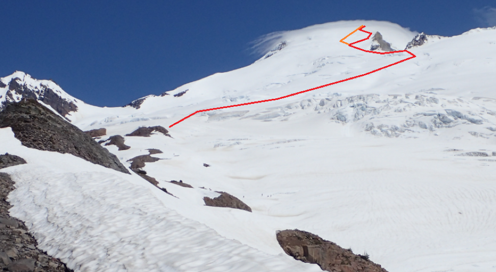
The red indicates our route up the Easton glacier and the orange indicates our way down. We took the red to stay close to the ridge to try and mitigate avalanche danger.

The red indicates the way up and the orange indicates the way down. A closer view of the headwall.

A look at the route up Sherman from the headwall. This is a more complete view of the route. Climbed a month prior.

Bonanza and Martin (July 19-22, 2014)
Bonanza (9,511ft) Martin (8,511ft)
July 19-22 204
Linsey Warren (Leader)
Mike R.
John P.
Pat C.
Kenny D.

-- Day 1 --
Eastgate – 4.00am
Field’s Point – 7.45am
Holden – 1.00pm
Depart Holden – 2.00pm
Holden Lake –
Holden Pass –
-- Day 2 --
Depart Camp – 7.00am
Base of rock – 9.45am
Bonanza summit – 12.10pm
Depart summit – 1.45pm
Base of rock – 3.50pm
Camp – 6.30pm
-- Day 4 --
Lucerne – 11.45pm
Stehekin – 12.30 – 2pm
Field’s Point – 4.45pm
Eastgate – 8.00pm
-- Day 3 --
Depart Camp – 5.45am
Martin summit – 8.50am
Depart summit – 10.10am
Camp – 2.00pm
Holden Lake – 3.20pm
Holden village – 5.15pm
Depart village – 7.20pm
Refrigerator Camp – 8.20pm est.

When I got the first email from Kenny suggesting a 4.00am meet time at Eastgate I was of mixed emotions. I understood the practicality of it as the roads had been a little iffy with all the fires and there was going to be a triathalon going on in Chelan that could hold us up. And if we missed the boat we were just SOL. But at the same time, I really did not want to get up around the 3.00am hour on a Saturday. The evening before I tried to get off as early as possible to finish packing and get home and get to bed so I could get a few hours of sleep. And just as I crawled into bed I got a text message from Mike saying he wasn’t sure he wanted to go because there were forest fires all over the state and in that general area and it might be hazy. I told him when I talked to the ranger she said it was okay but it was ultimately his decision. I was just too tired to fight it. I then sent a message to John indicating if Mike didn’t want to go we’d do a quick gear shuffle at the car but I was planning to still go. Shortly after Mike sent a message saying he was coming but I was too tired to argue it.
We met at 4.00am, packed up all the gear and bikes and headed over the pass. We made a quick stop in Cle Elum so the gents could grab some breakfast at McDonalds and we continued on. We ended up making great time and made it to Field’s Point on Lake Chelan around 7.45am. That was nearly two hours before the boat was scheduled to depart. We toyed with the idea of catching the faster boat back as I had misunderstood and thought we couldn’t take the faster boatback before of the bikes. But, we decided to stick with the original plan. We took the Lady of the Lake II up the lake to Lucerne, hoped off and loaded the gear onto the ol’ schoolbus Julianne (I think that’s the name painted inside the front of the bus). We had to wait until we got clearance to go up the road. It is quite a difference experience being there with the construction going on. We caught the bus up to the village and grabbed some lunch in the cafeteria. We were lucky they let us eat there, they indicated that they are trying not to encourage it but since we had planned on eating there they would let us. Right as we were finishing up lunch it started to sprinkle. It wasn’t so bad so we put our packs on and hit the road. We walked out of the village around 2.00pm in the afternoon. There wasn’t too big of a rush as we just had 7 miles to do to get up to Holden Pass. It kept sprinkling on the way up to the lake, gradually increasing in frequency and drop size until it was raining. And because the trail is brushy in spots we were pretty wet by the time we hit the lake. That is where we stopped and discussed if we wanted to continue on to the pass. I voted yes as well as John. But Kenny and Mike were inclined to sleep down by the lake. We called Pat the decided factor but somehow, likely due to my insistence that it would be better for us to be higher to tag both peaks, we continued on to the pass. It was not nice. We were going through the brush and slide alder in sections and just getting soaked. At one point, with all the clothes sticking to my body, I felt like I had just been dunked in a swimming pool and pulled out. I was just soaked. We stayed right of the lake and went up slightly to avoid some of the slide alder. After we punched through a short section it opened up into big scree and a little higher an open slope with a small beaten path. There were a few cairns to mark the way. We followed the path up to the pass and found a spot to set up camp.

I was getting cold at that point and someone had mentioned something about making a fire last time it rained on them. I asked if we could that this time. Although on the bus they had said no fires, given the fact it was raining and we were soaked it seemed almost like a survival scenario with minimal risk given the dampness. So we picked underbrush that was still fairly dry and I got my trip reports (the ones we had duplicates of since everyone seemed to bring Bongiovonni’s) and we shredded those and used those as tinder. It wasn’t long before we had a fire going! It was incredibly nice to stand in front of the fire. I couldn’t remember ever really building one to use in this type of situation but it proved incredibly invaluable. We all stood around it and tried to try our pants and coats. It was misting a little but it had for the most part let up on us which made it easier to dry our gear. It was an amazing feeling to start to feel warm and dry again. I was worried it’d be a miserable night being wet and that I might have to wear my long underwear bottoms the next day to climb in if my pants were still wet. But I managed to dry out my clothes and the pack cover on my pack, as well as the plastic bags almost everything was in, meant that my gear stayed fairly dry also. I crawled into my sleeping bag and John and Pat watched the fire as it went out. I slept fairly well that night and was pretty warm all things considered.
We had previously agreed to get up around 4.00am so that we could be moving by 5.00am. But at around our wake up hour Kenny came over to our tent and said that he was having some stomach troubles and asked if we wouldn’t mind pushing it back a little. Fine by me. I was warm in my sleeping bag and a couple hours wasn’t going to be a deal breaker. I’d really like to know who in their warm sleeping bag and right mind would have fought the later start? When we did get up and started pulling our gear out of the tent Mike pulled his backpack up and there were ants everywhere!!! We must have set the tent up on an ants nest and they came in through a small hole in the floor. It was gross. So we pulled everything out of the tent, tipped it upside down and shook it, then put it elsewhere and piled the gear back in. So we actually ended up getting up around 6.00am and getting started around 7.00am. We made our way up to the pass proper (we camped around 50ft below it) and from the pass we traveled west up a trail. The trail works its way up to the base of a rocky cliff face under which is scree and a small boulder field. We traversed under the rock wall (continuing in a westward direction) towards the waterfalls coming out of the Mary Greene Glacier. We hugged this rock wall a little closer and followed a series of little ledges, initially moss covered and green til it faded out in the waterfall and we had to work our way towards the center of the waterfalls and then upwards. It was slick but we didn’t need a rope to get up. Pat headed out first and cruised right up. We talked about roping up right there as the snow starts just above these waterfalls but opted to go without until a little higher up. We had no sooner decided that and got our crampons on then Kenny was off and heading up the glacier. We went about halfway up, weaving through some larger crevasses, without a rope. But it was when we needed to cross a potential snow bridge that Kenny decided it’d be a good time to rope up. The glacier was in surprisingly good condition. Very straight-forward conditions. Once we crossed the snow bridge (very solid) we traversed over to the ‘thumb’ on Bonanza. We initially headed left and then cut back right under the permanent hanging glacier and towards the base of the rock. The transition from snow to rock was fine. Hard to imagine that later in the year this moat can become impassable.

The base of the rock was quite nice. We stopped for a little food and to take our crampons off. In fact we ended up leaving our crampons, pickets and ice axes right there. We started the scramble upward and it was class 3 to start. We headed straight up alongside the hanging glacier. After 100ft or so it became a little more mixed class 3 possibly class 4. We ended up going up a steep section and getting into a little cave of sorts. Once there Pat dropped a line down and we prusiked up one section of smooth light colored rock that was friction with an undercling layback. It seemed we might have been off route but while we were sitting in that small cave (would be an excellent bivy from the elements if you aren’t scared of spiders or bugs) we noticed there was a piton. Additionally, there were other pieces of webbing in the area so we figured this must be one of the more common routes. I huffed and puffed a little up this section, and let out a couple choice words. Once above this short 25/30ft section of layback moves it became easy class 3 scrambling once more. We continued scrambling up and moving left (generally west/northwest).
The scrambling was fairly easy until we reached a smoother section of light grey rock that was more exposed. The moves were not hard and the exposure was not too bad but I asked for a line or a belay to be set up. A wrong move and tumble might be hard to stop. After traversing into this smoother light gray face we headed straight up into the gulley above. We continued up, Pat beat us up and dropped a line down in the gulley that we used to pull on in one of the steeper sections. This gulley had some class 4 moves. We followed this gulley all the way to the ridge just to the east of the summit. From this notch we scrambled directly west up to the summit. There is a section of darker rock that is a big chimney. The chimney is class 4 but easy and blocky moves that are not too exposed. At the top of the chimney is a little ledge we followed to another small notch 20ft away that put us directly on the summit ridge. We did not rope up for this section as it was fairly straight forward. We made good time as it took us about five hours from camp to make it all the way up. It was a gorgeous day with the clouds intermittently rolling in and out. It was a fairly decent summit as well. Enough space for us to lounge around and eat. I pulled out a bag of Newman’s alphabet cookies and we had some fun eating and spelling with those. John helped spell out ‘Shart’ on Kenny’s sleeve. Poor Kenny was not going to live down the morning’s bathroom escapades if John had his way! And Kenny was a trooper the whole way up. He tried not to eat so that he wouldn’t have any intestinal interruptions. As we dried our socks out on the summit and ate, John danced around with his camera and we gave him grief for his tripod and self portrait shots. But it was his words that inspired the summit sign “If I wanted lip from you I would have rattled my zipper”. And while he was running around taking photos and we were airing out our feet (Kenny, Pat and I) he set it up for the group shot and then ran over and accidentally stepped on a toe. I was yelling and making faces when the group shots when off!

We had a lot of laughs up there. I could have stayed for the better part of the day! It was stunning. The summit register is an old ammunition tin. It’s fairly rusty and the register was pretty wet but we all signed it. We down climbed back to the 4th class chimney and rappelled that. Then we used a series of 2 more rappels to get back down the steeper gulley. Although Kenny had to down climb one section so that we could clear the gear. Pat was a good guy and helped him navigate it. Then we down climbed the rest with the exception of the layback, cave area which we rappelled also. Then the rest of it we down climbed. Once we got back to the snow we had a snack and put our gear back on. We followed our tracks back down the glacier and to the waterfall. At the waterfall we set up a rappel on a boulder at the top. It looked fairly good but it is just a boulder sitting there. The water was running a little stronger in the afternoon and more of the rock that we had scrambled up was wet. The rappel was a little difficult as we rappelled at an angle and it was hard to get purchase to move diagonally on the slick wet rock. Mike took a tumble but held his hand on the rappel. We then continued along the slippery ledges back to the scree field and back to camp.
We made it back to camp by 6.30pm. It was a great day! We made dinner, got some water and hung around camp. More eating to be had. Pat pulled out a bag of Swedish Fish and his giant green hand crank radio. So we took turns cranking the radio and listening to music and random clips of whatever we could get up there. I was actually impressed we got anything at all. At some point during the day John told us about the Bon Qui Qui skit from SNL and kept saying “I will cuuuuuh’t you”. It was hilarious. It was a great day full of laughs and a good night. I crawled into bed and listened to the radio for a while as Pat cranked it. That night I didn’t sleep as warm and in the middle of the night I woke up and asked Mike if he had any food. I had put mine all in the bear bag after the ant escapades of the night before but Mike decided to sleep with his in his sleeping bag. But as soon as I woke him up I realized I had a bar in my pocket. Opps. And later in the night I woke him up again and asked if he was using his jacket as I was cold. Poor Mike. The good guy that he is he handed over his jacket and I used it to try and warm up. After having slept warm the night before it was hard to believe I was so chilly the second night. But perhaps it was because it was a mostly clear night.

We got up the next morning around 4.45am and got moving around 5.50am. Pat had thought about going with us but decided he was going to sleep in and hang with Kenny. They would sleep in and see how they felt about getting back to town. We headed towards Martin. We went up to an elevated section to the east of the low point on the pass. There are lots of great camp sites up in this area as well and a boot path of sorts that heads up towards Martin. In this area you have to drop a couple hundred feet on the other side to another low point at the base of Martin. We decided to follow the ridge. Immediately after the lowest point below Martin we traversed over to the toe of the ridge. It is a steep rocky section, after which it becomes a more gradual slope. We headed up a steep 4th class looking gulley that was quite loose and topped out in some shrubby trees. We scrambled up through the trees and gained the toe of the ridge. We followed it up it where the ridge steepens and then traversed over some scree fields. We made a rising right and upward traverse over to the first gulley. We dropped into this gulley and continued to make a rising traverse over to a second. We followed the second upward. There were some cairns on the route. Follow the path of least resistance upward. The gulley’s were loose but compared to lots of Bulgers and the Cascades in general it wasn’t too bad. We followed the gulley’s path of least resistance upward staying just on the right (or south) side of the west ridge. We came to a section of smooth downward sloping and crumbling light colored sandstone type rock. We scrambled up with without a rope but definitely noted it as a potential rappel point. From here we continued scrambling upward and had to make a series of traverses over ribs in short succession. But the scrambling stayed at about class 3 until just below the summit there is a little class 4 section that last for about 15/20 feet. We did not rope up to scramble up. We stayed right and went leftward up a dark colored chimney. It was blocky and easy moves. John went right up the center which went similarly.
We were on the summit by 8.50am. It took us three hours to get up and it was a gorgeous day. And it was nice to get to the summit and be in the sun because we were in the shade for the scramble up. We spent another hour and change on the summit because it was so glorious. So Mike and I sat down on the summit while John took his summit shots. We had to move our bags once or twice for John’s summit shots. It was really nice. We found the summit register which was an old metal tube from 1935 that said it was from the Wy’east Portland group. Again lots of laughs. John said something about lady lumps and so I got a lovely lady lumps pose pictures. After that we decided we better head down as we still had to make it down to Holden and it’d be great to make it by dinner. We rappelled off the summit to get past the fourth class section just below it. Then we scrambled the rest of the way down to the other short flaky section of sandstone and rappelled that. We then tried another short rappel after that but the rope got stuck so John scrambled up got in and down climbed the section. We then retraced our steps back and did one more rappel down the class four gulley through the trees and to the low point on the ridge. We retraced our steps back to camp and the temperature was really starting to warm up. We got to camp around 2.00pm and decided to pack up. Kenny and Pat weren’t there so we knew we’d have to meet up with them in town. Mike and I were ready really quick and there were bees and mosquitos around so I was ready to go. And also because my knee had been acting up and a little sore I wanted to start off first downhill since the guys would catch me in two second anyways. But we all ended up starting down together for the most part. But John was a little behind because he was taking amazing photos. We headed downhill and didn’t stop until we got to Holden.

It was nice that the brush was dry on the way down. When we got to town we strung up our food so that the chipmunks wouldn’t eat through our bags to get to it. And we met up with Pat and Kenny and went to the mess hall! We went in for dinner and it was glorious. I had some tacos and salad, some spiced cake and then some cereal with two and a half glasses of lemonade. It was marvelous. After dinner we left some money for our dinner and grabbed our bike and prepared to head down to Lucerne. It was just after 7pm and the road was officially open. And some event was getting out because people were milling about on the streets, it was like we had our own send off crowd. Our bags felt heavy and I just wasn’t that motivated to ride my bike down. As we kicked off and started down someone told me it was a great ride down. In my head I thought, maybe when you don’t have a heavy pack on after a long day and are an experienced rider but those were not quite my circumstances and I was a little nervous about going down. Mike said he’d go slow with me and he did. I held my brakes most of the way down. But made it eventually! It was nice that there were mile signs on the road too, that helped mark the progress. I was the last to scoot down the road and the others were waiting for me where the road branched. I thought we would sleep right next to the dock but Kenny thought it’d be good to go over to Refrigerator Camp so we rode the extra mile to that camp. When we got there it was still light out and we set up our camp and visited for a little while before going to sleep. We had gone up a mountain, down a mountain, had dinner and rode all the way to the lake in a day. And we had been blessed with great weather but it was cooling down a little bit and the forecast said there would be a chance of precipitation.
It was glorious to sleep in. I think we got up around 8.00am and hung around camp for a while. I woke up in the night and had to go to the bathroom and when I looked up I saw a tick. I thought it was on the outside of the tent so I didn’t really care. But the next morning Mike said something about pulling a tick of himself and the tick that was above my head turned out to be inside the tent!! Yuck! Mike got it out! We had some breakfast and snacks and mostly talked and joked around. I laid in the tent and kept my eyes closed for a while because it was so nice. But I had to laugh when John crept up to the mesh on the tent and said “I will cuuuuh’t you”. Pat went and took a dip in the water this morning and a little after 10.00am in the morning we got moving on the bikes to head over to the ferry dock. By this time it was definitely sprinkling. We got incredibly lucky with the weather window. We waited under a tree by the dock for the ferry to come. Then loaded our gear on and headed over to Stehekin. When we got off the weather was just pleasant. No rain and we headed over to the bakery. We had a lovely time eating and talking and laughing. We then headed back to the ferry. At some point John stopped to take pictures and when we got to the boat he wasn’t there. I thought for a moment he wasn’t going to make it, he sure was cutting it close! The whistle had already blown for the 10 minute warning before he had come whipping around the corner on his bike. And then we took the boat back to Field’s Point, jumped in the cars and headed home. We got back to the park and ride around 8.00pm. All in all a fantastic and fun alpine trip.

Trail Conditions –
Trail conditions were quite good. After the lake it is a little brushy but there is a faint trail through the trees and brush that leads to a better marked path marked with cairns on the way to Holden Pass.
Objective Hazards –
Slick scrambling up a waterfall, rockfall, glacier travel.
Gear –
Ice axe, crampons, helmet, harness, 4x 30m 8mm ropes, 4x cams, 1x set of nuts, 8 runners with biners, webbing, cordelette etc.
Water –
Running water available on the trail to the lake occasionally, water at the lake and some water running down from the pass. We were fortunate to find a snow patch at the pass that had enough water coming out of it to pump.
Animals –
A couple deer and chipmunks.
Bugs –
Mosquitos are out now. Ladybugs also. And I think I got bite by a fly!
Flora and Fauna –
Lots of flowers! Beautiful fields of flowers on the way to Martin at the pass. Yellows, red, white and some purple.
Lessons Learned
- A fire can be a useful way to dry out your clothes when you are soaking and it is safe to build one.
- Even a small hole in the bottom of the tent can let bugs in.


Tupshin, Devore, & Flora (July 4-7, 2013)
Tupshin (8,320ft) and Devore (8,360ft) and Flora (8,320ft)
July 4-7, 2013
Linsey Warren
John B.
-- Day 1 --
Arrive Stehekin – 12.00pm
Arrive Weaver Point – 12.45pm
Bird Creek Camp – 3.40pm

Basin Camp – 6.00pm
-- Day 2 --
Depart for Tupshin – 5.30am
Base of Tupshin rock – 8.00am
Tupshin summit – 11.45am
Basin camp – 3.00pm
Depart basin camp – 3.30pm
Upper lakes – 5.00pm
Devore summit – 7.15pm
Basin camp – 10.00pm
-- Day 4 --
Rise and Shine depart – 5.00am
Tenmile Pass – 7.00am
Holden Village – 9.15am
-- Day 3 --
Depart basin camp – 6.00am
5,400ft camp – 12.00pm
Depart 12.30pm
Fourth Col – 2.00pm
Flora summit – 5.30pm
Fourth Col – 9.15pm
5,400ft camp – 12.00am
This trip just had so much to it I’m not even sure where to begin. Originally, John and I planned on climbing Dark and Bonanza but due to mine remediation and potential thunderstorms during the crux of the trip so we quickly redirected (literally on the car ride up) and went for the Tupshin, Devore and Flora traverse. We had four days and that seemed like a push, especially considering this ‘mine remediation’ meant that we absolutely had to catch the bus at 10.45am from Holden Village to get the ferry out of Lucerne to get home because the road was closed and it didn’t run on the weekdays.
So on the drive up we decided to head for the traverse, we bought our tickets and then ran quickly into Chelan because I needed some bagels and pop tarts. We dashed back to the ferry, parked the car and boarded! And per our usual luck I ran into someone I knew. Gretchen Lentz and her friends were headed out to try Flora! And funny enough as we got talking we got onto the subject of how to get to trailhead from Stehekin. The standard way is to catch the bus up the road and then hike back three miles towards the Weaver Creek Trailhead. But it was hot and we had heard rumor that sometimes you can convince someone to ferry you over on their boat to the campground. When we got into Stehekin we asked around but no one seemed interested or able and being the fourth of July weekend people were more interested in other things. John and I kind of gave up quick since the bus was going to leave in fifteen minutes and the next one wasn’t going to leave for two hours. So it was catch the bus or take the chance of trying to get a boat ride and potentially save time. So when it looked like we weren’t going to find someone we hopped on the bus. Three miles is just three miles after all. But when it looked like Gretchen and company might have found a ride we stalled the bus driver to find out and the poor guy was waiting while we tried to figure out our situation. As it turns out Phil had found a guy that would ferry us over to Weaver Camp and drop us off. So we grabbed our packs and ran off the bus while John yelled ‘Keep the money’ at the bus driver. It was like a scene from a movie. And as that happened I cut my finger on something and it started to bleed. Right out of the gate! First blood!
This nice gentleman (Adam?) filled up the lower part of the boat with all of our packs and we all squeezed onto the back benches. Combined we donated $60 to be ferried across and saved hours. We didn’t fully appreciate how much it had saved us until we started going up the dusty switchbacks from the lake in the hot midday sun. And then we were blessing Phil and Gretchen’s group. When we got off the dock I had to put a bandaid on because the little cut just kept bleeding! Then I changed into shorts because I was looking to get a little sun on my casper shade legs. We packed our bags and said our adieus and headed off. From the dock at Weaver Point follow the signs northwest towards the Devore Creek Trail. It heads up a little into the hills and then follows old power/telephone lines for a ways until it crosses a river on a log with a handrail and shortly after that (heading north) there is a sign on the left hand side indicating the Devore Creek Trail. From here we followed up the steep switchbacks towards the mountains. This trail gains elevation surprisingly quickly. Shortly after the trail heads back towards the river it becomes very brushy and the trail is a bit uneven so what underfoot. It’s fairly straightforward but if it became more overgrown it might be hard to follow. I had to stop and put my pants back on because my legs were getting scratched and itchy. We followed the trail for about four miles until we hit the Bird Creek camp sites at about 4,250ft. It’s a nice little campsite. We stopped and enjoyed the momentary clear space and pumped water from the creek before heading uphill. We originally headed uphill into the brush on the north side of the creek (climber’s right) and it was fairly straight forward for the first several hundred feet but we ran into brushy sections and the tendency was to keep moving farther north (climber’s right) which worked okay we just ended up having to traverse some steeper cliffy sections. It had clearly been done before as we came across a cairn. As we traversed back to the south (climber’s left) to get back to the basin between Tupshin and Devore I whacked my knee (same knee that got whacked on Buckner not a week before) and it hurt intensely. At this point we were hot, tired, bleeding and frustrated and the mosquitos were starting to come out. And since it was getting later in the evening we decided to continue on and head to the basin. We traversed around the edge of the cliff band into the basin between the two and made camp at about 5,800ft. There aren’t a lot of flat places in the meadow so we just threw our bivies out. I wasn’t too excited to get bit by mosquitos and was not having a good afternoon so John let me crawl into his hooped bivy and he pumped water and got dinner going. It was a nice birthday gift! As it was my birthday! So I iced my knee with a bit of snow John found in a patch not too far from where we were camping.

We called it a night early but I really wasn’t too keen on sleeping in a medium height grass slant with no mesh on my bivy – who knows what would want a cuddle in the night!! So John and I decided to see if we could fit two people in his bivy. We actually did get the thermarests in and us with our sleeping bags but it was a bit of a tight squeeze and I woke up a few hours later with my arm numb because the fabric had been pulling so tightly on it. Time to get up and get into my own bivy – experiment over and I just wanted to sleep!! We set the alarm for 5am or so and got moving at around 6am. From the basin we headed almost immediately north up the meadowed slopes. It is fairly straight forward picking a line up and the brush thins after a short period of time. After the massive bushwhack of the day before this wasn’t bad at all. We followed it until we intersected the southeast tending arm off of Tupshin at about 7,200ft. We crossed over the ridge and ran into our first solid patches of snow in the traverse over to the southeast basin of Tupshin. We tried to kick steps without crampons but that early in the morning it was still a little crusty so at about halfway across the traverse into the southeast bowl we put on crampons and booted up to about 7,600ft where the snow ends at the base of a steep rocky face. There are several ramps that head climber’s right. We took the middle ramp which inclined up towards a tree at the base of a chimney with a small chockstone. We scrambled up this chimney and then decided to leave my pack behind. From here we roped up and headed up short steep rocky sections and then veered right when we hit a ramp. Although the ramps often headed towards a corner the scramble route often did not go around the corner. So in this fashion we continued upwards until we hit a quite steep looking section that was near the upper right (east trending arm) and that is where you can go straight up or traverse around the somewhat exposed corner. Both end in a similar spot it’s just that the corner puts you out a little higher, which is what we did, and we had to scramble down a little gulley section to get back to the scramble section. In this case the ramps traversed back (climber’s) left and up to the base of another chimney. This is where the low fifth class section is. It’s not too bad I didn’t it in my mountaineering boots. After this chimney the grade lessens a little and we continued climbing straight up. One full pitch brought us to the upper ridge section. From here the easiest way may be to scramble the eastern ridge up to the summit. We, however, followed another chimney as it didn’t feel exposed and it was about a half a pitch to a three quarters of a pitch up loose rock to the summit. This cleft/chimney we followed brought us out right between the notch in the summit. Lovely. The top was really loose. As John was coming up I had to yell ‘Rock Rock Roooock’ at least once or twice as they were knocked loose by the rope.

Since we were planning on doing Devore this same day we only had a quick bite and then got ready to descend. I must say I wasn’t overly excited about descending since it was a bit loose. But on the way up we had passed several rappel areas which helped us know which way to descend. So we made several rappels back down. There were a couple goofy rappels where we started in shrubs and all our gear got caught on stuff. John got half caught in some shrubs on his way down and I had to laugh but it wasn’t as funny when I went and the whole rack got caught all over the trees! We rappelled to the base of the route and scrambled the last section back to the snow. The snow was fairly hard still, surprisingly, so we put our crampons on and started walking down. It was quite steep for a bit but the run out is fine so we headed down. I had my ice axe in my hand and a piece of poptart I was eating in the other and I slipped as I was scooting half down face forward and had a chunk of poptart in my mouth. I started sliding so I went into arrest and stopped after about 10/15 feet. I got up and looked at John and was like ‘Did you see that arrest?!’ and he was like ‘She didn’t even drop her cracker!!’ referring to the fact that I just slid and kept the poptart in my mouth. I was proud of that! I slipped and went into arrest but I didn’t lose any part of my poptart! Shazaaam! That’s how it’s done! It happened once more that I slipped and went into arrest so I took off my crampons which were balling up and plunge stepped down the rest of the way back to the ridge and back down into the basin. We arrived back in camp at around 3pm. We knew we wouldn’t have time to dolly around a lot so we refueled on water and snacks and about thirty minutes later we headed out. Although it was funny when we arrived in camp John noticed that the spare two liter bag he had filled was half empty. And we have no idea why it was half empty unless a critter came along and had a sip and put the lid back on. Other than that it showed no signs of having been chewed on.
From our camp in the basin at 5,800ft we headed immediately south up a snowy ramp (will be rocky and scree when melted out) until a basin immediately to the north east of the lakes. This is the correct way – not via the waterfall on the northwest side of the lakes which we thought about for a moment. From this scramble we worked our way up and to the highest scramble point and then worked left through a small lightly treed section at the base of another higher basin. From this basin we scrambled up the scree and snow to the upper rim (there are trees up the center) and this put us out at the northeast side of the lakes at the base of Devore’s north side. From the lakes we worked our way up the snow to the ridge. We did not head to the lowest point on the ridge because it looked steep and like it might have a small cornice still on the top and to the right there was a rocky notch so we headed for that. The snow was fairly good consistency and John kicked steps up. I was starting to feel the day at this point and we were still carrying the rack and rope as we had heard that people rappelled off the top of Devore as well. From the ridge we travelled west along it. The top was fairly easy to traverse but we did have to drop about 20/30 feet below the ridge on the south side and scramble along scree for part of it. It is fairly straightforward just follow the ridge until it hits a large darker shaded hump on the ridge. From a ways off it looked unclear how we would get around but as we got closer we realized all we had to do was hop on the snow to the climber’s right (north) and scramble around the dark knob. It was easy and straight forward and not exposed. We hopped off on the ridge on the other side and traversed over to a gulley and up the gulley. It’s a bit loose and rocky here but not too bad. Once we topped out on the gulley we could see that the ridge turned northwest and what looked like the summit. It’s a fairly straight forward class 3 scramble over to the ‘false summit’. Just below the false summit there is a class 4 possibly with a couple class 5 moves to get up to the next scramble section (its only about 20-30 feet). From here I belayed John up and I scrambled up to what I thought was the summit but as soon as I got near the top I could see the true summit was northwest behind this one. It looked hard to get to at first so I back tracked down and John came over and looked and saw a ramp around the corner. So we rounded the southwest corner and followed a ramp over to the base of the actual summit. From here we roped up again and I led up the class 4 potentially class 5 (with boots on) little section. But there looked to be a gulley around to the southwest of the summit that could be scrambled without a rope.
That being said once we topped out and it was getting later in the evening we decided to snap a couple pictures on John’s phone as my camera had been left behind at the original step/rope up to the false summit. After the photos we set up a rappel to rappel the 80/100 feet back down to the notch between the two summits and from there we followed the ramp back around to the step before the false summit and rappelled back down to the scramble section. We packed up our gear and wasted no time hauling off as the sun was going to be setting very soon. We followed our tracks back down and my knee started to act up. Not the one that had been bashed in the day before but the other one. Okay. Weird. But no time to fiddle around. We followed our route back the way we had come up and made it to just below the lakes when the sun set and darkness moved in. I was scooting on my butt on the snow where I could to avoid using the knee but the last bit we had to do scramble down and in the dark we got a little bit off and bushwhacked around through bushes we hadn’t been through on the way over just to cross the stream/river to get back to the camp. And we made it! And this time John’s rock shoes were laid out on the ground where he hadn’t left them. Mystery remains. Our camp got moved around a little. Im still not quite sure how. There were deer milling about all day that weren’t scared of us so maybe they rooted around a little? Either way I’m not sure. But we were pretty darn tired once we got back into camp at around 10pm. We pumped water and made some mountain house dinner before we crawled into our sleeping bags and tried to sleep. But for the second night in a row we didn’t get great sleep. Odd but at least the stars were gorgeous.

The next morning it was hard to get up and get moving but we had a long day ahead of us and I was concerned my knee would hurt enough that we’d have to turn around and head back to Stehekin to guarantee we’d make a boat out. And neither John nor I had any or a lot of drugs. I had a couple packets of Tylenol but that wasn’t going to be enough if it got real bad. So we bushwhacked back towards Devore Creek trail. This time we made sure to head straight down following closer to the Bird Creek River. It was a bit steeper and brushier but overall it went fine. John might say otherwise since he had to go first to clear the spiders and climb through the slide alder. Once we regained the trail it was like throwing a small party. We came out right at the campground which was awesome because that’s just about as clear as the trail got. We had a quick break and then continued to follow the Devore Creek trail uphill and south. We had to ford a small creek/river at one point by taking off our boots and wading across. It was actually a good wake up call for my feet. After that we followed the trail for a few miles until we intersected the topo at 5,100ft where we had read there was camp to stage out of in order to get to Fourth of July Basin. We never came across a camp and we had a hard time distinguishing basins because all of the maps intersected or were broken up right in this area and the information we were reading just wasn’t great. The whole trip the beta was kind of bad. John and I talked about providing better beta but at some point John said that we shouldn’t that everyone else should have to suffer like we had! And that is probably why it has remained like it has for so long.

At about 5,500ft we crossed the Devore Creek River. We had to cross a little higher up the river as the water was a bit high and there was no easy way to cross. We still got a little wet but it worked fine. We made our way back to the main trail and found that right on the other side of the river crossing was a great campsite. We decided this was it. Drop our gear and make this our staging ground for Flora. It was just about noon when we arrived so we stopped and pumped a little and dumped our gear. It was bushwhack from here up to the Fourth of July Basin (which was northeast traverse around the base of an arm into the basin. At one point John was crawling over a log and snapped off a branch that was dead and yelled ‘This is how I feel about this trip!!!’ as he threw the branch down on the ground roughly. We bushwhacked (same slow annoying going) up until we hit a rocky boulder talus basin and then continued up that until we topped out at the col at about 7,200ft. In this Fourth of July Basin we must have hit some sort of limit because everything was cracking me up! I couldn’t stop giggling and laughing. Just looking at John’s broken up pack with broken straps and wholes all over it (mostly from this trip) to stilly random thoughts floating around my head. We sat down and I just giggled. John told me it was better than crying. Haha I guess that’s what it was.

From this col we thought we could see Flora but you actually can’t you can see Point 7,734Ft. The summit is northeast from the col so up the climber’s left. There is a small looking boot path that could carry up and over to the ridge but we weren’t sure and there wasn’t a lot of information so we dropped down and traversed around at about 6,900ft. Once we rounded the corner we decided we would head back up to gain the ridge because we weren’t sure where we were or where we were going! We gained the ridge and then seeing as it was already since it was already 2.15pm we were questioning whether or not we should continue. The ridge was long and it was going to be a long traverse. We decided to have a 4pm turn around and go as far as we could and if we were within striking distance we would go for it. So we literally flew like the wind around the ridge until we were about a third of the way between Point 7716 and Point 7734 and that is when we realized that the ridge was going to take too long if we were going to follow it. The quickest and easiest way for us at that point looked to drop down into the valley and then up Flora via the southwest slopes. So that is what we did. We plunge stepped into the Castle Creek Basin and then up the steep mostly open but treed slope to get to the plateau below Flora. It was a bit of a steep scramble in one or two spots but presumably if one were to work around further to the north it’d open up into a wider gulley. Either way straight up to the plateau from the basin at 6,600ft worked fine. Once at the plateau the snow tapered off a bit and it was mostly a melted out scree fest to the top. It wasn’t the works but it was still scree. So John dropped his pack and we combined into one. From the base of the plateau it’s only about 1,000ft to the top.
So we scrambled up as quickly as we could. At this point after the long days we’d put in I was really feeling this and I periodically had to stop and take a breather. John joked that it was like going up Everest and we were doing the rest step. So I jokingly made loud breathing sounds like an oxygen mask and that’s about what I had the energy for. We scrambled to the top. It’s an easy scramble of class 2 or 3 to the top. Once we got there we took some photos and I added some cold water to our Mountain House Chicken Salad. I was starving and kept feeling sick because I needed water and food. But as I started to munch on the mix a giant spider crawled across a rock near me. Not funny. I scooted off and told John if it came back it’d be a problem. Of course it came back so I scooted right up next to John. We didn’t dally about long and John carried the pack on the way down. We hadn’t finished the chicken salad, really we only had a few bites but we were wiped and it was getting late. So I stashed the remaining chicken salad in the pack and left. We had made the summit around 5.30pm and we left around 5.50pm. We followed our same tracks back and it felt so surreal. We were tired and there was still sigifnicant ground to cover to get back to where we had dropped our gear. So we went down into Castle Creek Basin and back up to the ridge and instead of following the ridge which was time consuming we dropped down into the upper Riddle Creek Basin and around to the col catching up with our original steps at around 6,900ft where we traversed.
The sun was setting and we were trying to get as far down as we could before it become totally dark. But we knew we were going to be doing the bushwhack in the dark and that wasn’t sounding pleasant. We made it to the Fourth of July Basin upper col as the sun set and we glissaded down the upper portion to where it was sections of talus and snow and walked back to the original boulder field where we had entered. At this point it was totally dark and finding our way was by headlamp. We headed into the brush and started making our way back. It felt abominably long. The great thing about John and I as a team is that when one of us is tired or dragging usually the other has enough energy or momentum to keep the team going and this is where John picked it up and went first on the bushwhack in the dark but his headlamp started dying. Of course. So we stopped in the cluster of bushes and tried to change out the batteries but we couldn’t get the headlamp open and we were at high frustration levels already. And with thunder and lightning just north of us we were ready to keep moving. So I gave John my headlamp and I used his slowly dimming one on the way out following in his steps. We got cliffed out several times and had to make our way. And as we went the GPS showed signs that the battery life was running low. Oh great. What else?! Well as it turns out the what else showed up not too long later when I looked down at John and said ‘Where’s your gaiter?’ and he looked down at his leg and noticed it was gone and he looked back hopeful for a moment and then said ‘It’s gone’. The straps had gotten banged up and broken earlier and I guess the brush just ripped it off. Our backup plan was to make it to the river and then traverse back to where we thought camp would be about. It wasn’t ideal and we did make it back to camp before the batteries died. Praise the Lord. But it was midnight when we made it back. I told John I wasn’t going to cook anything or pump any water I was crawling into my sleeping bag and going to bed. It was a twenty hour day and we needed to be up in four hours to hike out to try and catch the Holden bus. I tried to have a snack of the chicken salad and whatever else I could scrounge up cold but the chicken salad had exploded in my pack… awesome. I’d be lucky if animals didn’t come savaging around in the night. I crawled right into my sleeping bag and passed out. I didn’t sleep that great and I kept waking myself and John up with my incessant babbling. Apparently I was talking about 10.45. Go figure.

We woke up as the skies were grey and there was little light but we were exhausted so we slept in another thirty minutes. But after that we got up and packed up and headed out. We followed the trail for a little while until we crossed a creek and right after we stepped over this tiny creek we lost the trail in the snow and brush. Crap. John and I just did not have time for this. We searched around but we couldn’t find the trail so we headed off in the direction we suspected it might generally go and hoped that we’d intersect it at somepoint other than that I guess our plan was to bushwhack to more open terrain? I don’t really know. It was an exhausted hope and a prayer at this point. Thankfully we intersected the trail and it carried us up and over to Tenmile Pass. We descended off the pass and realized we just weren’t losing elevation that fast and we wanted to be extra certain that we didn’t miss the last bus out of Holden (aka the last plan out of Saigon). And because we weren’t seeming to gain ground that fast we started doing a slight jog downhill. John yelled ‘double time’ and said he felt like he was in the military running with a full pack. So I gave him a good couple hooouu hooouuu’s! We worked our way down to about 5,000ft which is where the trail gets rougher but right now it is currently well marked with blue flagging. So it’s easy to follow. We were expecting the hard part of the trail to be between 4,700 and 4,300ft where the trail does not appear on the map but actually that was okay. The only real issue here was that we had to cross a river and we didn’t want to take off our boots and it was quite wide and fairly deep in some spots (perhaps a foot and a half two feet) so I put on my gaiters and ran across. Later in the year I suspect this is not so much of an issue.
From 4,700ft we easily followed the trail down. We ran into our first people about a mile and a half from the town of Holden right after John got a tremendous cramp in his leg. He was limping and struggling to keep walking. We were officially approaching ‘mess’ status. As we descended our back up plan was to cut straight to the road if we had to and run in front of the bus! But since we could hear the giant construction machines in the valley from halfway up to the pass we did think twice about running onto the mine remediation road. We hustled to Holden but my feet felt like they’d been beaten with a stick and I could barely walk but we had to get there before we took a long stop because otherwise it’d be hard to get going again. And at long last, we walked into Holden Village. It was a ghost town because of the mine rehabilitation so we made our way to the registrar and paid for our exit out of the town. We had missed breakfast by 15 minutes. Bugger. So we stumbled to the front of the building and dropped our packs. I pulled out some of my gear to dry and pulled off my boots to let my trenchy feet dry out a bit. As we sat there these aggressive little chipmunks ran up and started chewing on my pack! Little blighters! They actually found an already partial hole in my hip pocket that had a small whole in the gorp bag and really made it a treat. We couldn’t keep them away. We heard tales of how they’d come into town and steal the food of your plate. Awesome. So we arrived in town at 9.15am and waited for about an hour and a half talking to the people in town and learning about the mine rehabilitation while our stuff dried out. And we had to laugh at the state of John’s clothes on the trip – his whitish gray shirt was just an unrecognizable shade of dirty!! And his pants had smears all over them. He had changed into a new shirt for the way out. A courtesy shirt. I was in my courtesy shirt too but was in a similar state of just dirty.
I started to doze off in the middle of the walkway. John told me I should probably be mindful of the people but honestly it was the best spot and there weren’t that many people! We were two of the five people that road the bus down. We made friends with them and continued to chat while we waited the couple hours for the Lady Express to arrive. When we boarded there was a trail of gorp on the gangplank to get on… guess who’s pack it was from? We got on and I pretty much passed out. I was out for what I’d guess to be an hour. It was so hot. And on the ride back we learned that on the fourth of July a fire had started out near Chelan. Once we got back to the dock we quickly grabbed our packs and got off and headed for the car. As we crossed the main street and headed up to the car holding area I tripped over my own shoelaces that had got caught on the metal clasps on the shoes and since I didn’t have any straps on the pack done up the pack went up over my head and I went down onto the pavement. What a way to end the trip. But in some ways it made sense. We quickly changed and headed into town for a snack and on our way in we ran into the same fellows who caught the bus with us from Holden so we picked them up and dropped them off at their car in downtown Chelan and we decided to join them for pizza. John and I got their first with just enough time for me to knock a glass of ice water all over the table before the other two gents arrived. We had a lovely lunch/dinner before we got in the car and headed home! The trip felt a lot like a dream. Several times John and I commented on how surreal and fast time moved. And to lend even more to the surreal factor John kept calling the peaks those peaks we climbed. Haha I don’t know if he remembered them the first couple days. But by the second or third day he had come up with a new name for Tupshin – Tupshit which turned into Tough Shit. And then John came up with Devore as ‘Devour Me’.
Trail Conditions –
I don’t even know where to begin with this one. The trail was clear in some spots and disappeared under brush and other debris in other places. Overall it was okay to follow but in several sections it was hard to follow.
Objective Hazards –
Rockfall, navigation, lightening and general exhaustion. There were a couple small river fordings. If it was during the heavy meltout time of the year the rivers may be hard to pass as there are no bridges.
Gear –
Rope, rack, 2 pickets, crampons, ice axes, harnesses. We did not use the pickets.

Water –
There was plenty of water for the majority of the trip as there is still enough snow melting that being said later in the year without any standing glaciers for melt off there might be a limited supply. The last 1,000ft of each peak had virtually no water supply.
Animals -
Lots of deer!! My goodness! Also the sound of whistling marmots and some aggressive little chipmunks in Holden.
Bugs -
Yes. Mosquitos, spiders, and a wide variety of other flying insects. One of which I swallowed so we’ll never know about that one.
Flora and Fauna –
Flowers were starting to appear lower down. Lots of glacier lilies.
Lessons Learned
- It’s hard to drink enough water.
- Two people can fit in John’s bivy in a real pinch!!
- John and I make a good tired/powered duo! When one is tired the other helps push on!
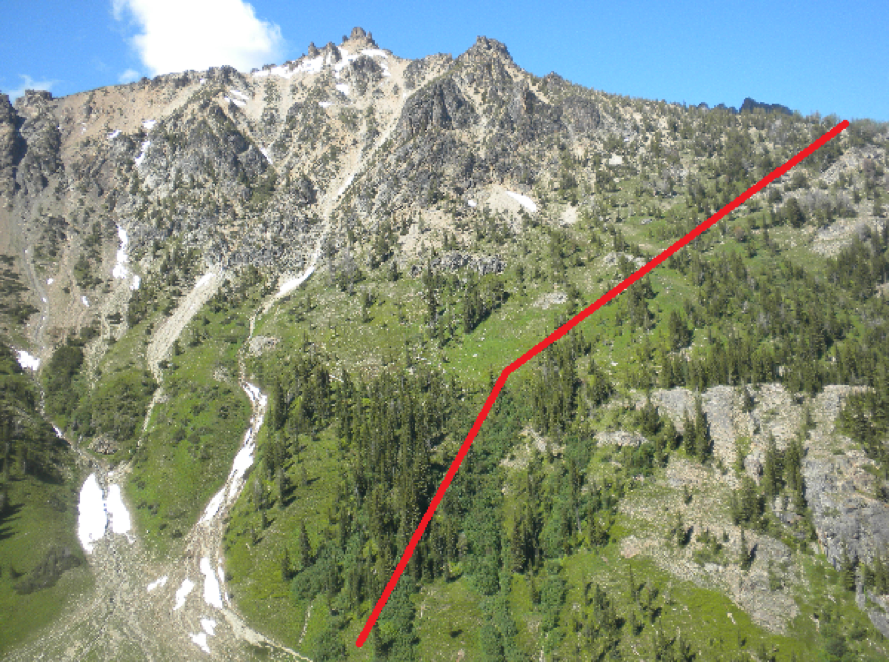
This is looking up the South side of the route to the 7,200ft arm on Tupshin.

Approximate route up - real approximate. It looks very different while on the route!

Looking up the scramble route to the lakes below Devore.
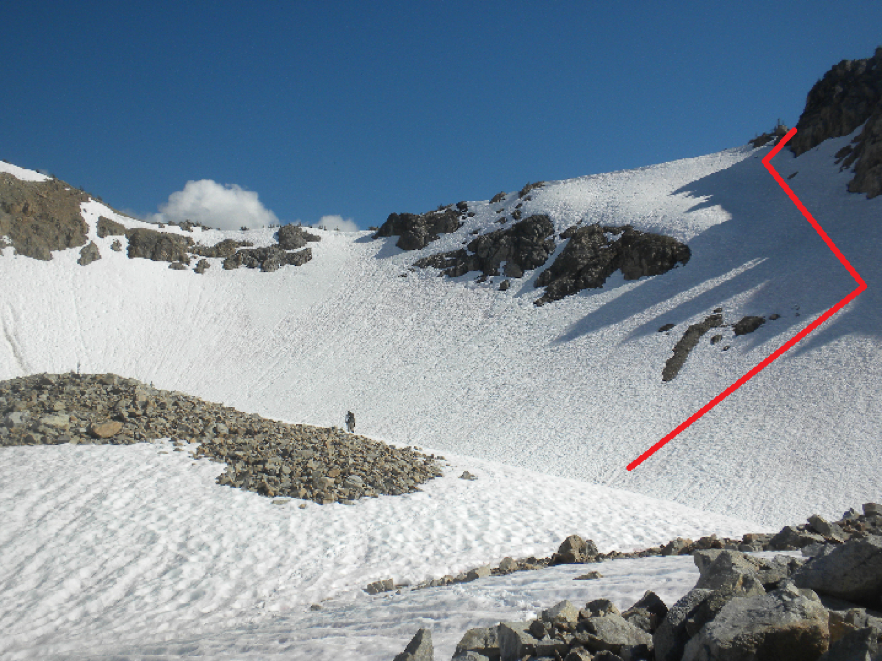
Looking up from just east of the lakes towards the ridge at about 7,400ft.

Looking northwest along the ridge towards the summit after topping out on the gully. This is the false summit that is so tempting. Go around the corner and the true summit is immediately after.

Looking up the Fourth of July Basin.
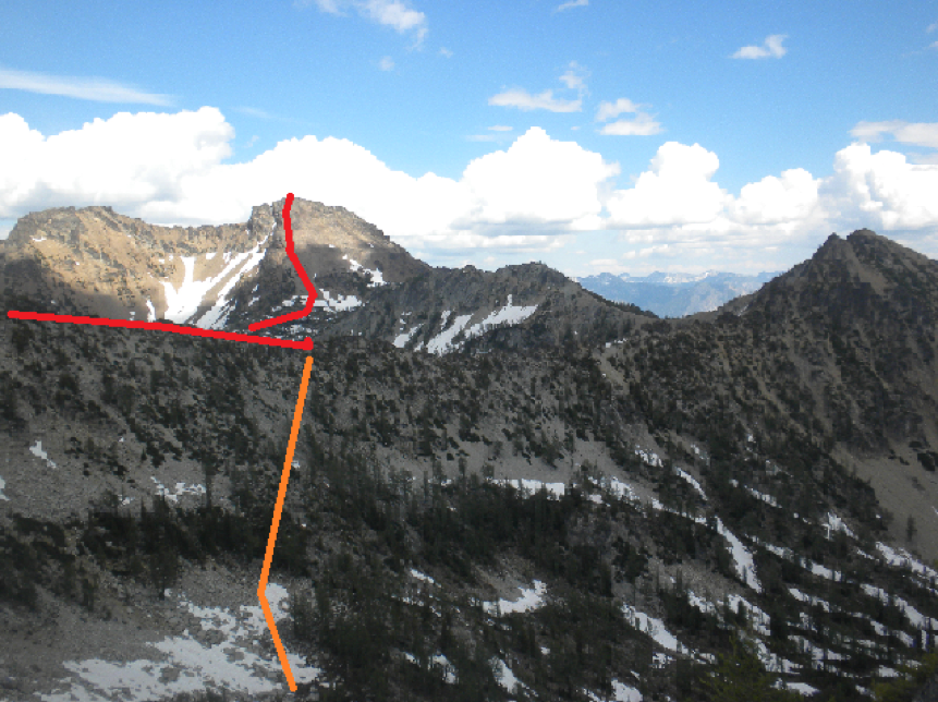
The red indicates where we followed the ridge and dropped down into Castle Creek. The orange indicates where we dropped back into Riddle Creek upper basin to save time. This was taken from around the col. It was about 20/30 minutes back at this point.

Robinson Mountain (June 11-12, 2011)
Robinson Mountain via SE Ridge (8,726ft)
June 11-12, 2011

Linsey Warren (leader)
Kyle Finnegan
-- Day 1 --
Car Camp
5.15 am – Rise and Shine
6.00 am – Hit the trail
10.30am – Camp (approximately 6,400ft)
11.00am – Begin heading up basin
3.00pm – Gain the ridge (8,000ft)
4.00pm – Summit
6.00pm – Camp
---Day 2---
7.30am – Rise and Shine
8.00am – Head down
11.30am – Arrive back at the trailhead!
Kyle and I ran a ton of errands the night before we headed out to the North Cascades – but we finally got on the road a little after 8.30pm from Bellevue. We made it to Mazama around midnight and pitched a tent at the Robinson Creek Trailhead (9 miles west of downtown Mazama). Trying to be a little more on the realistic side of things we set the alarm for 5.00am but when it went off it took an additional fifteen minutes to get moving! We hit the trail at approximately 6.00am and headed up the Robinson Creek trail. About a mile or so along the trail we came to a ‘log crossing’ that looks to be the beginning of a really solid bridge that hasn’t been finished. There are three logs placed parallel that run across the river – and as they are fairly close together they form a good solid and wide base. Immediately after this there is a good camp spot! Really flat, shady area! But alas, we kept going! We hiked for about another mile until we crossed over Beauty Creek on a lovely bridge. Just after the bridge on your right (approximately 60-75ft) there is a decently obvious climber’s trail that begins to switchback uphill.
The hill up from Beauty Creek was covered in glacier lilies and was quite beautiful! The going was pretty straight forward but there was no obvious trail. Occasionally, we would stumble across what looked like small game trails but generally we just headed straight up running parallel to the creek coming down from the tarn. Just above snow level, at about 6,400ft we decided to ditch the heavy gear and set up camp. I found a decently level spot between some trees and we pitched the tent. I didn’t level the ground because it seemed okay – and of course that would come back to bite us later!! We grabbed some water and some food and headed uphill. It was slow going and quite hot! There was no shade in the basin and we kicked steps the whole way up! Although the ground was relatively firm it didn’t stop up for doing the occasional posthole up to our hips! We eventually made the ridge and the going was a lot easier up on the ridge. There was not as much snow and the scree was relatively stable and made for quicker going.
The east side of the ridge had some bigger cornices so we stayed well away from that! But the ridge seemed to be easier going because it was rockier and when we got off onto the snow patches they were unpredictably deep in some spots. We made it to the base of the ‘false summit’ in good time and saw the class 4 scramble route. It is a little exposed as a fall could result in a decent size tumble on either side (approximately 400ft to the east). I went ahead and traversed the little snowy col/ridge over to the scramble. The rock was fairly straight forward but there were one or two sections of rock that were covered in snow that were slightly trickier. The snow covering a couple section was very powdery and hard to make good purchase in – but that was only in one or two spots. I also walked carefully along the top of the scramble since there was snow covering the rocks there and I wanted to be careful that I didn’t puncture through a cornice or thin snow. The last bit of scramble to the summit was straightforward! I tagged the summit and down climbed the false summit and headed back down the ridge with Kyle. We were both ready to be at camp. When we got to the top of the basin we traversed over to a clean line and plunged down, glissading closer to the bottom.
After that we followed our footsteps back into camp. We melted some water and heated it up for our sleeping bags as our boots and socks were soaking wet!! Luckily for us we had brought a new Mountain House meal along, the ‘Chicken Salad’ one that only requires 10oz of cold water mixed in. So we ate that and some of our leftover snacks and called it good. We probably should have heated up the other Mountain House but crawling into a sleeping bag was just too tempting! During the night we slide a little downwards as it wasn’t quite level and condensation built up in the single wall tent because I forgot to open up the air flow zips! Opps! But fortunately we were able to get up and going and the weather held Sunday morning. The way down was relatively straight forward and we just followed our original tracks. All the streams and creeks seemed to be running quite high – but they didn’t pose any real objective hurdles. When we got back to within a mile of camp we ran into a group of day hikers who told us they’d seen a rattlesnake a little ways down the trail and that they’d marked the spot with three X’s so we’d know to look out. Very kind – but we didn’t see anything! The cars were lovely – but even better was the tasty sandwich and fresh bread from the Mazama store! Estimated 6,400ft gain and 13 miles.
Conditions/ Objective Hazards –
Snow conditions seemed fairly solid although there was evidence of pas sluffs and slides. Some big cornices on the ridge should be avoided. The class 4 scramble up the false summit was a little trickier with very powdery snow concealing a few harder sections – but passable.
Trail Conditions –
Clear up to about 5,000ft and then there are sections of snow but they are passable and the trail is still fairly straight forward. Just after crossing the creek (which intersects Beauty Creek) we headed uphill towards the tarn. This clear terrain was fairly easy going and there were several game trails on it that made for good going too. At about 6,200ft we hit snow again and from then on up to 8,000ft (start of the ridge after the basin) and intermittently after that we were kicking steps.
Bugs –
A few – saw a couple mosquitoes but nothing biting.
Water –
Was available up until about 6,000ft when the river became mostly covered with snow. The tarn marked on the map is completely covered. There were a few sections of melt off flowing over rocks up high and sections where we could hear the water running under us – but not a lot of readily accessible water after 6,000ft.
Animals –
Lots of deer!! We saw some larger mammal tracks but couldn’t tell what they belonged to.
Gear –
Helmet, poles and snowshoes – although we did not use the snowshoes.

Looking up the basin at approximately 6,600ft

After reaching the top of the basin a look at the route along the SE ridge
Big & West Craggy (August 5-6, 2010)
Big Craggy (8,470ft) and West Craggy (8,366ft)
August 5-6, 2010
Linsey Warren
Kyle Finnegan
-- Day 1 --

1.15pm – Leave Copper Glance Lake TH
7pm – Summit of Big Craggy
8.15pm – Camp on the Craggy Col
-- Day 2 --
6.30am – Rise and shine!
7.00am – Leave Col Camp
7.54am – Summit West Craggy
10.40am - Base of Craggy Col
1.15pm – Arrive Copper Glance Lake TH
We left the trailhead around 1.15pm after we finally found it! It took us a while since we thought we were on the Eightmile Road and were following it for a ways when it turned out we’d missed the turn off and were on Thirty-Mile Road. A good way to know if you’re on the right road is to take the left hand turn marked only as road 1530. It almost immediately turns to a gravel road – and that’s the one you want! We accidently stayed on Thirty-Mile which is paved the whole way. We actually ran into a County work force. Kyle and I laughed and felt like we’d stumbled across a scene from ‘O Brother Where Art Thou?’ when we saw the stripped uniforms laboring on the side of the road.
We got going and the trail was solid. Easy going. The book says to veer right after the trail crosses Copper Creek and so we literally did and bushed whacked to the base of Big Craggy. The bush whack wouldn’t have been so bad had it not been for the mosquitoes. We passed a small pond (not marked on the map) before going up and to the scree. We hit scree around 4pm and realized we’d need more water soon and the only visible water was a small lake below us (immediately SE of Big Craggy – but not marked on the map). Although it appeared most mountains in the area still had snow on the N sides and so we hoped we’d find some run off and if not carry over to the ridge between Craggies and make camp and decide what to do. Luckily we came across a patch of snow – not so fortunately there was no stream to pump and Kyle was really needing water – so I pulled the stove out and we melted enough to drink and mixed it with 50% snow. I had forgot a bottle so I was trying to be extra cautious and conserve. When we reached the “summit ridge” on the E side there were more patches of snow but still no real run off that could be filtered. Quick summit shots and a pika later we went to descend the WSW tending ridge. But in spots it was difficult to follow and wasn’t really helpful on the descent – just on the traverses. So it was a good marker, but it didn’t make the descent a ton easier and the route was quite clear. There wasn’t any snow in the middle of the ridge (approximately 7550ft) – a few spots on the N side a little lower. But we decided to make camp since we’d felt a few sprinkles and there was thunder and occasional lightening to the S. Made camp in a really nice spot between a tree and a rock (so pretty sheltered) and pretty flat. Kyle has no idea how lucky we got!! Could hear things moving all night. Finally I woke Kyle up and he said he hadn’t heard anything – he looked outside the tent and said he didn’t see anything but later checked again and saw a goat wandering around. Lots of tracks in the area lead me to believe they’d been poking around. The lightning flashes lasted all night.

Looking down from the West Craggy’s high ridge –the ridge between Craggies.
We got up around 6.30am and had a snack before we left around 7am. I had our food and water to consolidate gear – and I had the smaller pack. We traversed the ridge on the S side below the ‘top’. At one point we climbed to the top of the ridge for a better vantage point and realized we’d made more work for ourselves because there is a ‘cleft’ in the ridge – which drops about 30/40 feet and must be descended to go around. After that it is relatively straight forward – traversing W and up aiming for a notch in the high ridge. After having gained that notch it is a really quick jaunt to the summit traversing the W side of West Craggy which is a relative gentle, albeit expansive, scree slope. We reached the summit around 7.54am. I was a little concerned about how hazy the air had been all day. It looked like smoke to the S and NW. The descent went well – although Kyle knocked a big rock down! We packed up camp quick and descended immediately off the ridge.
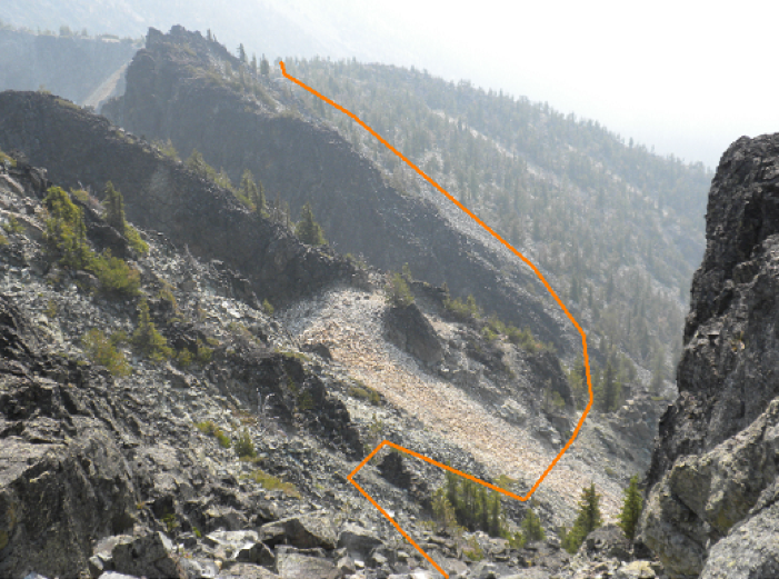
Lower down the SE route.
Saw goat tracks, but not human, so I’m guessing we took a little less of a standard route. We came down between the two small lakes (again not on the map but located at the top of Copper Creek and about 200/400 vertical feet down). We pumped water and tried to take a quick break (mercifully free of mosquitoes but the ants, ticks and bees were enough motivation to move. And in order to avoid all the bushwhacking we stayed closer to the base of a ridge. Eventually, I knew we’d have to do a little and we delved in. Kyle first because I scream when I get the big full body webs on me. And of course the mosquitoes came back full force once we entered the moister tree region. So Kyle got to hear my constant – move faster!! I don’t want to get bit! We came out right by the lower ‘pond’ marked on the Copper Lake Trail. Flushed with success and over the mosquitoes we made good time on the trail. Back to the cars around 1.30pm.
Conditions/ Objective hazards –
Rock fall and loose rocks. Overall minimal exposure though.
Trail Conditions –
When used, good and clear. Off trail, cross country was primarily scree.
Bugs -
Yes. Mosquitoes around the creek and bushwhack, but other than that not too bad.
Water –
Above the lakes it is only available in small patches of snow (didn’t see anything ‘pumpable’.)
Animals -
Not many! A goat, a pika and a few chipmunks.